The lowest elevation angles for the Ontario radars are
-0.1°
and 0.0°, respectively, during the winter and 0.3° during
the summer.
http://journals.ametsoc.org/doi/pdf/10.1175/WAF1019.1
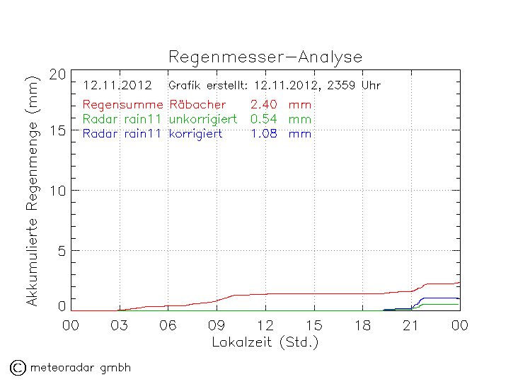
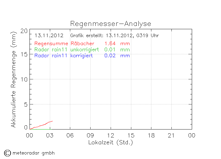
In der Schweiz also wohl kaum praktiziert, in den Staaten jedoch möglicherweise schon. Der Strahl wird ja dann möglicherweise wieder nach oben gebogen. Für mehr Details kenne ich mich zu wenig aus, folgt vielleicht in den nächsten Woche in der Vorlesung Fernerkundung. Jedenfalls ist im vorigen Paper mehrfach von knapp negativen Winkeln die Rede, bis etwa -0.4°
http://journals.ametsoc.org/doi/abs/10. ... 2.0.CO%3B2
About one-third of the Weather Surveillance Radar-1988 Doppler (WSR-88D) radars located in the western third of the United States are on the tops of mountains. These mountaintop radars employ scanning strategies that were designed for flatland radars, with the lowest elevation angle being +0.5°. Consequently, the radar signals are sent well above the populace and terrain surrounding the radar. The inability to adequately detect low-altitude weather events results in missed warnings of severe weather and in underestimates of the amount and areal extent of precipitation. Mountaintop radars could be utilized much more effectively if the scanning strategies included negative elevation angles. The state of Utah has the disadvantage that all three of the WSR-88Ds used by the National Weather Service to monitor weather events in the state are located on the tops of mountains. To determine the extent to which negative elevation angles would improve the detection capabilities of these radars over Utah and portions of the adjacent states, a WSR-88D simulation model is used to compare the existing scanning strategies with those that incorporate negative elevation angles. As might be expected, the use of negative elevation angles enhances low- to midaltitude detection of weather events over a much larger area than is possible using the existing scanning strategies. For example, the area where the centers of the beams from the three radars currently are within 1 km of the ground encompasses only 2% of the area within 230 km of the radars. Using negative elevation angles, the areal coverage within 1 km of the ground increases to over 30%.