Seite 2 von 12
Re: [FCST/NCST] Gewitter am 04.07.2014
Verfasst: Do 3. Jul 2014, 22:06
von 221057Gino
hallo zusammen
@Cedric ( hoi )
danke cedric
wollte es auch mal probieren ( synoptic )
sorry ! ... will ( möchte ) dazu lernen ...

ich dachte eben wegen den Tiefs ( gegenuhrzeigersinn )
===
hier noch ein loop
EWN WRFDA 12 km
europe

Re: [FCST/NCST] Gewitter am 04.07.2014
Verfasst: Fr 4. Jul 2014, 06:43
von Chicken3gg
@ Gino: Skala rechts passen nicht zu den Farben auf dem Bild. Oder missinterpretiere ich da etwas?
Ja aber das Tief ist bzw war doch übeder Biskaya oder Iberischen Halbinsel. Bzw Hoch östlich von uns. Also Südwestanströmung. OdereSüd, aber woher du die Ostkomponente nimmst, bleibt mi ein Rätsel?
Re: [FCST/NCST] Gewitter am 04.07.2014
Verfasst: Fr 4. Jul 2014, 08:44
von deleted_account
Estofex mit Level 1 und Level 2 in der Schweiz:
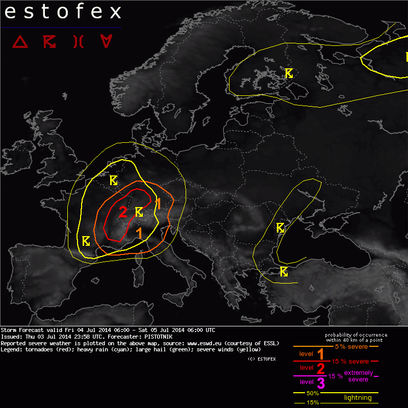
A level 1 and level 2 were issued for E France, Switzerland, W Austria and SW Germany mainly for large hail and severe wind gusts.
A level 1 and level 2 were issued for S France, the Ligurian Sea and N Italy mainly for large hail, excessive precipitation and severe wind gusts, and to a lesser extent for tornadoes.
SYNOPSIS
A meandering zonal flow is active over Europe. A negatively tilted short-wave troughs moves from Northern Spain into the Alpine region. An intense surge of warm air advection pushes northward between this trough and a transient ridge over East-Central Europe. It includes elevated mixed layers which spread from the Sahara over the Central Mediterranean and from the Alps over much of Germany. Cooler maritime air advances eastward over the British Isles, France and Iberia, though a distinct frontal boundary is missing.
Southeastern Europe is dominated by anticyclonic influence with mostly friendly conditions and seasonable temperatures,
while a decaying low over Finland brings cool and unsettled weather into Northeastern Europe.
DISCUSSION
... S and E France, Switzerland, SW Germany ...
Low-level moisture will continuously increase on Friday under the influence of strong insolation and suppressed mixing beneath the warm air advection. Moderate CAPE with peak values around 1000 J/kg or higher is predicted to build till the evening, initially capped by a rather strong inversion. Deep-layer shear will be between 15 and 20 m/s, in general increasing towards the Southeast.
Intense QG lift overspreads Southern and Eastern France during daytime and the Alpine region in the evening and overnight. It is provided both by the short-wave trough and by the left exit region of a pronounced mid-level jet (35 m/s at 500 hPa) that swerves in from the Western Mediterranean.
The day will likely start with rather cloudy conditions, scattered rain and partly embedded thunderstorms over Southern France. Chances for surface-based convection increase in the course of the day, as a Southerly low-level jet advects Mediterranean moisture northward through the Rhone valley. Multi- and supercells are expected, some of which may be backbuilding and remain almost stationary as long as they encounter sustained Southerly inflow. Large hail and flash flooding are the primary risks along with isolated severe wind gusts. One or two tornadoes are not ruled out, either, due to rather low cloud bases and enhanced low-level wind shear and veering.
Almost unimpeded insolation will prevail further North and East till the early afternoon, followed by increasing high cloudiness thereafter. The sharpening thermal contrast and northeastward moving outflow boundaries will likely trigger scattered storms from noon onwards over Eastern France and Switzerland with an increasing hail and wind risk.
Highest uncertainty exists with respect to the degree of low-level moisture recovery and the behaviour of the near-surface wind field on the Northern side of the Alps. Unseasonably strong Southerly flow across the Alpine chain may well push hot and dry Foehn winds some distance into the Northern foreland. The resulting dryline boundary with the moister air to the North will need particular monitoring ahead of the approaching French convection. If it aligns favourably with the track of one or several of these storms, they can grow into a long-lived bow echo, which will be capable of producing a larger swath of damaging winds while it moves northeastward into Germany in the late afternoon and evening. Highest chances for such a development exist along an axis from Lyon to Karlsruhe.
Quelle:
http://estofex.org/
Re: [FCST/NCST] Gewitter am 04.07.2014
Verfasst: Fr 4. Jul 2014, 09:15
von Thomas Jordi (ZH)
Hier die zwei Druckwellen, die Cosmo seit gestern recht penetrant modelliert:
Re: [FCST/NCST] Gewitter am 04.07.2014
Verfasst: Fr 4. Jul 2014, 09:25
von DomE
Ich fliege heute nach Basel und sollte Planmässig um 17 Uhr in Basel landen.
Wie gross ist die Gefahr dass genau um diese Zeit Gewitter sind, und könnte mein Flug sogar gecancelled werden?
Re: [FCST/NCST] Gewitter am 04.07.2014
Verfasst: Fr 4. Jul 2014, 09:51
von Chicken3gg
DomE hat geschrieben:Ich fliege heute nach Basel und sollte Planmässig um 17 Uhr in Basel landen.
Wie gross ist die Gefahr dass genau um diese Zeit Gewitter sind, und könnte mein Flug sogar gecancelled werden?
Ein paar Zusatzschlaufen oder eine Landung in Zürich schliesse ich mal nicht aus.
Re: [FCST/NCST] Gewitter am 04.07.2014
Verfasst: Fr 4. Jul 2014, 11:00
von Joachim
Hoi
In den Föhntälern schon bis 26 Grad:
St. Maurice/VS
Innertkirchen/BE
Urner Reusstal
Liechtenstein/St. Galler Rheintal
Kl. Matterhorn und Gornergrat bis 106 km/h, Brülisau 102 und Erstfeld 85 km/h
Und het au wieder Schtaub i dr Luft:
http://forecast.uoa.gr/LINKS/DUST/zoomdconc/024.gif
vG
Joachim
Re: [FCST/NCST] Gewitter am 04.07.2014
Verfasst: Fr 4. Jul 2014, 11:57
von Severestorms
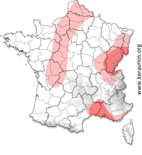
Nachdem sich der vergangene Samstag zu einem Flop in Sachen Superzellen entpuppte, habe ich für heute wieder Hoffnung. Ich wäre sogar erneut überrascht, sollte es heute Nachmittag am Jura nicht klappen.
Nicht nur die Superzellen-, sondern auch die Tornado-Parameter springen an. Keraunos sieht die Tornadowahrscheinlichkeit wie folgt:

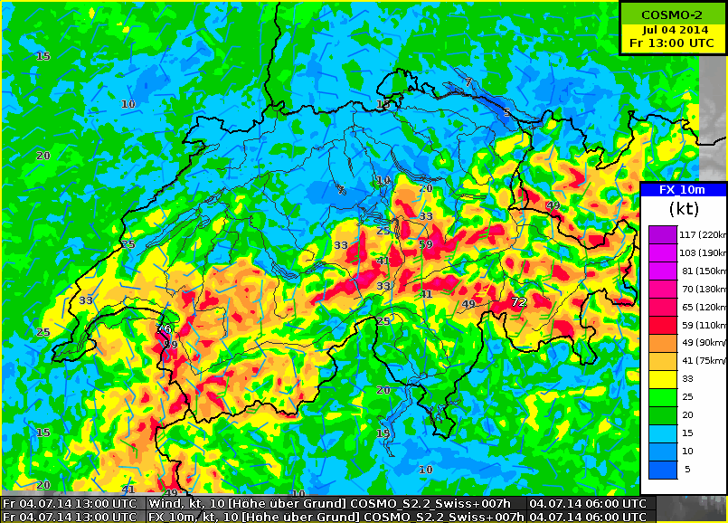
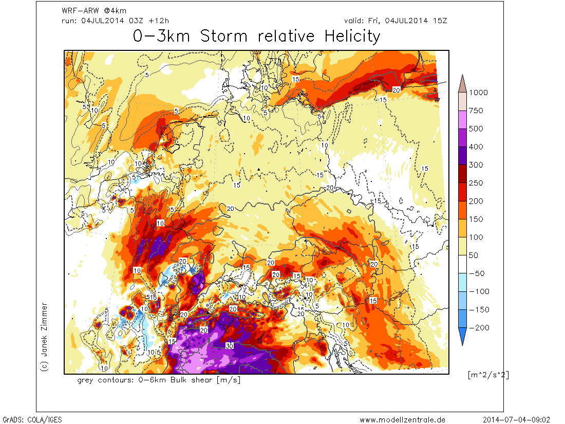
Das könnte unter anderem an den geproggten SRH-Werten liegen, siehe Raum Basel, heute am späteren Nachmittag:
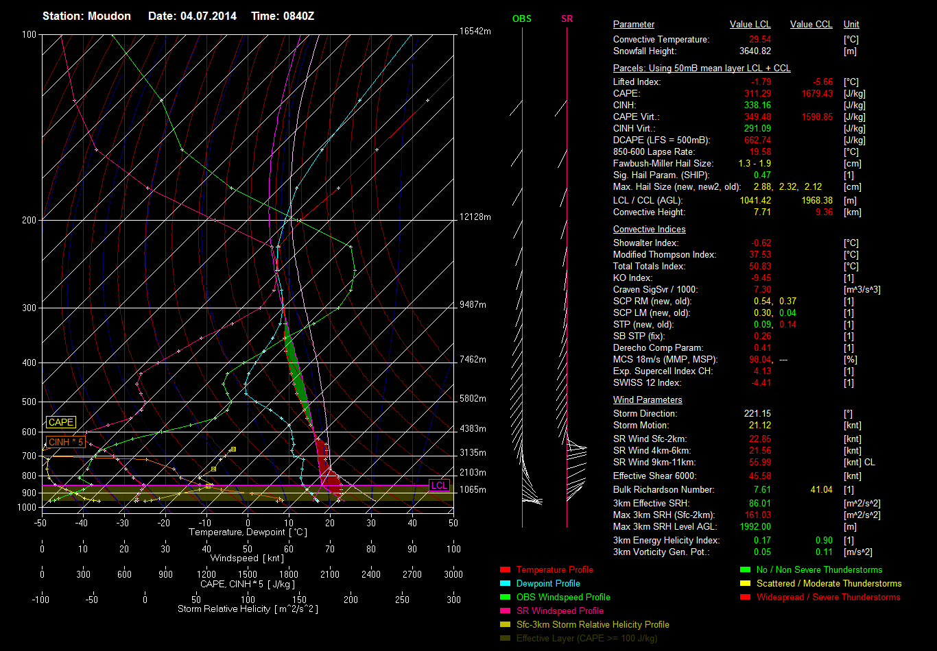
Anhand des aktuellen Pseudo-Soundings von Moudon (VD) ist das interessante Scherungsprofil sichtbar. Erkennbar sind drei Jets, einer auf 250hpa, einer auf 500hpa und einer auf 850hpa. Auch zu erkennen ist die noch starke Deckelung, welche zusammen mit den sich entwickelnden CAPE-Werten von über 1000 J/kg eine LGS hervorrufen wird.
Gruss,
Chris
Re: [FCST/NCST] Gewitter am 04.07.2014
Verfasst: Fr 4. Jul 2014, 13:27
von Chicken3gg
Die Temperaturen sind ja schon mal schön hoch:
Flachlandstationen Höchste Temperatur (in °C)
Buchs SG (448 m ü.M., SG) 30.1
Flüelen (434 m ü.M., UR) 29.6
Schattdorf (466 m ü.M., UR) 28.8
Evionnaz (480 m ü.M., VS) 28.8
Altdorf (449 m ü.M., UR) 28.3
Brienz (566 m ü.M., BE) 28.2
Walenstadt (425 m ü.M., SG) 28.1
Sitten (482 m ü.M., VS) 27.7
Chur (555 m ü.M., GR) 27.5
Altstätten (444 m ü.M., SG) 27.4
Pratteln (296 m ü.M., BL) 27.3
Meiringen (589 m ü.M., BE) 27.2
Schwyz (448 m ü.M., SZ) 27.2
Unterterzen (425 m ü.M., SG) 27.1
Bad Ragaz (496 m ü.M., SG) 27.1
Liestal (333 m ü.M., BL) 26.8
Glarus (515 m ü.M., GL) 26.7
Vaduz (460 m ü.M.) 26.7
Frenkendorf (337 m ü.M., BL) 26.5
Basel-Binningen (316 m ü.M., BL) 26.2
Frutigen (799 m ü.M., BE) 26.2
Riehen (278 m ü.M., BS) 26.1
Meiringen (589 m ü.M., BE) 26.0
Dazu der Föhn...
Gütsch (2287 m ü.M., UR) 124
Piz Martegnas (2670 m ü.M., GR) 122
Gornergrat (3135 m ü.M., VS) 105
Les Diablerets (2966 m ü.M., VD) 95
Altdorf (449 m ü.M., UR) 95
Titlis (3040 m ü.M., OW) 88
Säntis (2502 m ü.M., AR) 87
Meiringen (589 m ü.M., BE) 86
Wiliberg (651 m ü.M., AG) 85
Jungfraujoch (3580 m ü.M., BE) 83
Weissfluhjoch / Davos (2690 m ü.M., GR) 82
Naluns-Schlivera (2400 m ü.M., GR) 79
Glarus (515 m ü.M., GL) 76
Warten wir mal ab, was aus der Loaded Gun wird...
Re: [FCST/NCST] Gewitter am 04.07.2014
Verfasst: Fr 4. Jul 2014, 13:44
von Bulilu
Welchen Einfluss auf die Gewitter in der Nordwestschweiz hat das Niederschlagsgebiet welches von Norditalien langsam richtig Südschweiz zieht und nach Cosmos-2 (bin mir nicht mehr sicher, ob der Niederschlagsfilm von search.ch auf dem Cosmos-2 oder Cosmos-7 basiert?) bereits um 17 Uhr einen flächigen Schauer in der ganzen Ostschweiz bringen soll?
Edit: Es scheint am Juranordfuss bereits los zu gehen. Zu früh?
