auch noch was auf you tube....!
live on the scene..... http://www.youtube.com/watch?v=DNL7ASvl4k4
gewaltig - gewaltig......da stockt einem der Atem!
Grüess Edy
:O

Werbung
StormChasing USA 2007
-
HB-EDY

- Beiträge: 933
- Registriert: Sa 27. Jan 2007, 15:22
- Geschlecht: männlich
- Wohnort: 8607 Seegräben/570m
- Hat sich bedankt: 171 Mal
- Danksagung erhalten: 17 Mal
- Kontaktdaten:
StormChasing USA 2007
I like stormy nights...................!
Wetterstation Seegräben 570m
http://www.kaikowetter.ch/mc/meteoplug_seegrabenX.html
Wetterstation Seegräben 570m
http://www.kaikowetter.ch/mc/meteoplug_seegrabenX.html
-
crosley

- Moderator
- Beiträge: 1938
- Registriert: Fr 13. Aug 2004, 15:48
- Geschlecht: männlich
- Wohnort: 5000 Aarau
- Hat sich bedankt: 419 Mal
- Danksagung erhalten: 386 Mal
- Kontaktdaten:
StormChasing USA 2007
Das BavariaStormTeam ist ebenfalls ab dem 12.05.07 in den Plains unterwegs: BavariaStormTeam.
PS: Übrigens ein tolles Tool für die Gewitterbeobachtung in den USA, ist das Programm GRLevel3! Es arbeitet mit den Daten von NEXRAD.
- Es können diverse Ansichten gewählt werden.
- Warnungen erscheinen sofort in einem Zusatzfenster, mit eine Doppelklick darauf gelangt man automatisch zur entsprechenden Radarstation.
- Es kann nach diversen Kriterien gefiltert werden.
- Man erhält allerlei Informationen zu den jeweiligen Zellen (beim darüber fahren mit der Maus)
- die Radarbilder können archiviert werden
.... und noch vieles mehr!
Es gibt das Programm als Trial-Version (Gratis für 21 Tage) zum downloaden unter:
GRLevel3 ( http://www.grlevelx.com/grlevel3/ )
Hier noch ein Printscreen von GRLevel3 (damit man sich etwas vorstellen kann)
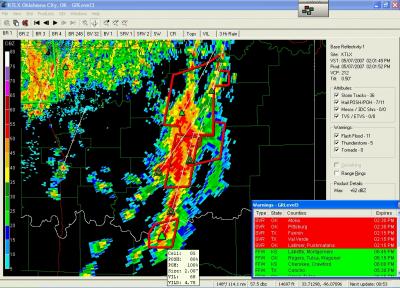
Gerade für die kommende Zeit, sicher ein spannendes Tool und wer es danach nicht kaufen will, löscht es einfach wieder.
Grüsse Crosley
-
Bernhard Oker
- Moderator
- Beiträge: 6519
- Registriert: Do 16. Aug 2001, 11:02
- Geschlecht: männlich
- Wohnort: 8902 Urdorf
- Hat sich bedankt: 1867 Mal
- Danksagung erhalten: 3116 Mal
StormChasing USA 2007
Markus, Marc und Susanne Danßmann sind nun auch in de Tornado Alley angekommen und der erste Bericht ist Online:
http://www.meteomedia.ch/usa07/
Die Chancen für Tornados sind heute nicht mehr so gut wie in den letzten Tagen, daher auch nur ein Slight-Risk vom SPC.
In Nord-Texas könnte es vereinzelt einen Tornado geben, aber der kräftige Upper-Level Jet fehlt für klassische langlebige Superzellen.
Gruss
Bernhard
Bernhard Oker - Urdorf (ZH/CH) - Meine Webseiten "Never Stop Chasing!"
-
Klipsi

- Beiträge: 1156
- Registriert: Do 16. Aug 2001, 13:08
- Geschlecht: männlich
- Wohnort: Sion
- Danksagung erhalten: 4 Mal
- Kontaktdaten:
StormChasing USA 2007
kleiner Druckfehler :
auf der website steht : .... wieder in den Great Planes unterwegs ...
korrekt heisst das Great Plains, nicht Great Planes. Planes sind Flugzeuge. Plains sind die flachen Länder.
auf der website steht : .... wieder in den Great Planes unterwegs ...
korrekt heisst das Great Plains, nicht Great Planes. Planes sind Flugzeuge. Plains sind die flachen Länder.
-
Gino
StormChasing USA 2007
Excite Weather ...
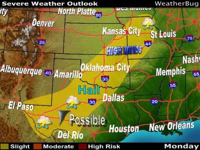
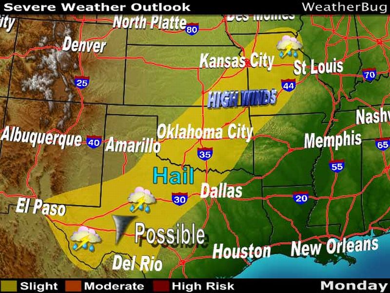
Severe Storms Rolling Across The Southern Plains
9 PM CDT, May 7, 2007
UPDATED By WeatherBug Meteorologist, Adam Bell
The active weather pattern that has generated three consecutive days of severe thunderstorms across the Central Plains has ignited another round of showers and storms this evening. These storms, staying confined to Texas, Oklahoma and Arkansas, will continue throughout the nighttime hours.
These storms have formed along and ahead of a slow-moving cold front associated with an area of low pressure drifting through the Great Lakes. While the severe threat with these storms will continue to diminish as the night progresses, the threat for heavy rainfall will be a constant threat.
These torrential downpours could trigger isolated cases of flash flooding. Increasing the vulnerability for flooding is the already saturated soil from all of the recent storm activity over the last week or two.
Click here for the latest video about the Central U.S. flood potential.
The catalyst for the widespread severe thunderstorm activity has been a large dip in the jet stream over the western third of the U.S. This has led to the development of a slow-moving north-south oriented cold front stationed over the Central Plains. Storms, fed by a strong jet stream above and Gulf of Mexico moistures streaming into the Plains ahead of front, have been forming every afternoon and evening along and ahead of this front.
On Sunday afternoon and evening, 10 tornadoes were reported across Kansas, Oklahoma and Texas. No injuries or deaths were reported from Sunday's storms but a tornado near Seminole, Okla., knocked a trailer from its foundation and destroyed a barn. Tornadoes that struck Langdon, Kansas and Little, Okla. damaged trees and knocked out power to local communities.
What do you think of this story?
Click here for comments or suggestions.
=
Bild dazu ...
=
Quelle: http://weatherbug.excite.com/StormCentr ... &lid=SCBCS
-
Gino
StormChasing USA 2007
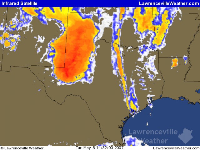
USA Regions Warning ... ( LawrenceVille Weather )
http://www.lawrencevilleweather.com/war ... uthcentral
Quelle: http://www.lawrencevilleweather.com
=
Central Plains Severe Weather Exercise ...
http://www.comet.ucar.edu/resources/tut ... setup.html
=
Fort Worth Tornado Tutorial ...
http://www.comet.ucar.edu/resources/tut ... p_fwd.html
- Editiert von Gino am 08.05.2007, 10:01 -
-
Gino
StormChasing USA 2007
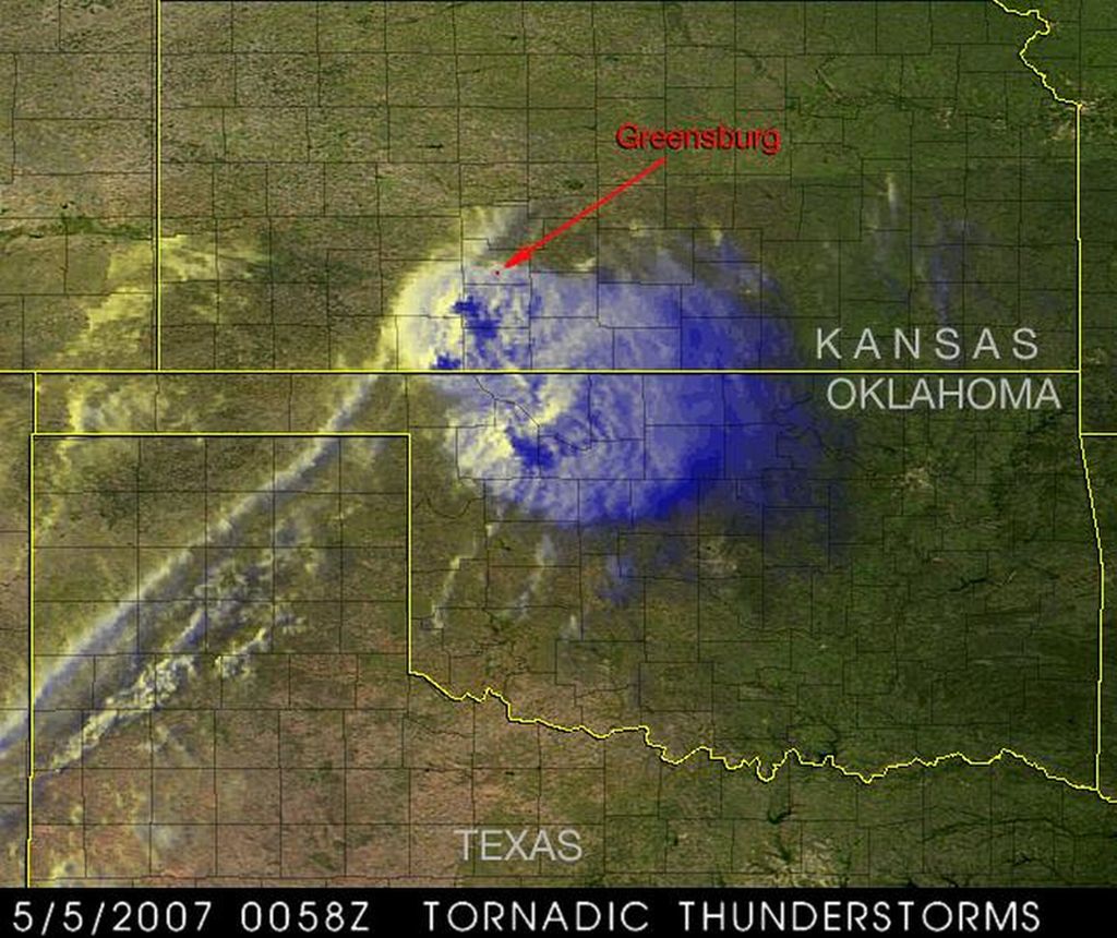
Einmalig ... Satellitenbild vom Tornado über Greensburg ... aufgenommen von TRMM Satellite am 05.05.2007

Quelle: http://trmm.gsfc.nasa.gov
Quelle: http://trmm.gsfc.nasa.gov
-
Chrigu Riggisberg

- Beiträge: 1470
- Registriert: Fr 23. Apr 2004, 23:20
- Wohnort: 3132 Riggisberg BE
- Kontaktdaten:
StormChasing USA 2007
@ all: Stellt die Wolkenlinie südwestlich des Gewitterkomplexes die dryline dar? Auf dem Bild von Gino habe ich diese rot markiert:
http://www.sturmforum.ch/forum_uploads/ ... 194016.jpg
Noch eine allgemeine Frage: Bilden sich Gewitter, welche an eine dryline gebunden sind, eher auf der feuchten oder trockenen Seite? Kann man da überhaupt etwas sagen?
Gruss Chrigu
http://www.sturmforum.ch/forum_uploads/ ... 194016.jpg
Noch eine allgemeine Frage: Bilden sich Gewitter, welche an eine dryline gebunden sind, eher auf der feuchten oder trockenen Seite? Kann man da überhaupt etwas sagen?
Gruss Chrigu
Riggisberg BE (800 m.ü.M.), zwischen Schwarzenburg und Thun am Fusse des Gurnigels gelegen
-
Gino
StormChasing USA 2007
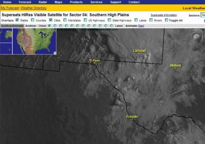
Kennt jemand Supersats today? ... Man kann Haarscharf die Gewittertürme wachsen sehen ( Manuell oder Loop ).
Gut für StormChaser ( Sturm Jäger ).
Aber nur wenn in den USA Tag ist ( VIS Bilder ).Hier ein Beispiel ( Aktuell ) ...
Anfang ( Loop )
Ende ( Loop )
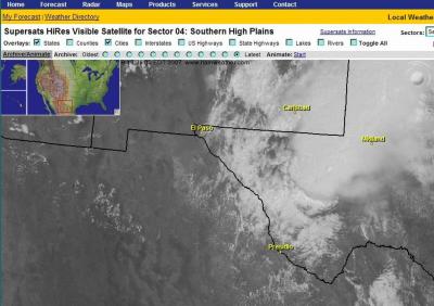
Quelle: http://www.hamweather.net
Gut für StormChaser ( Sturm Jäger ).
Aber nur wenn in den USA Tag ist ( VIS Bilder ).Hier ein Beispiel ( Aktuell ) ...
Anfang ( Loop )

Ende ( Loop )

Quelle: http://www.hamweather.net
-
Gino
StormChasing USA 2007
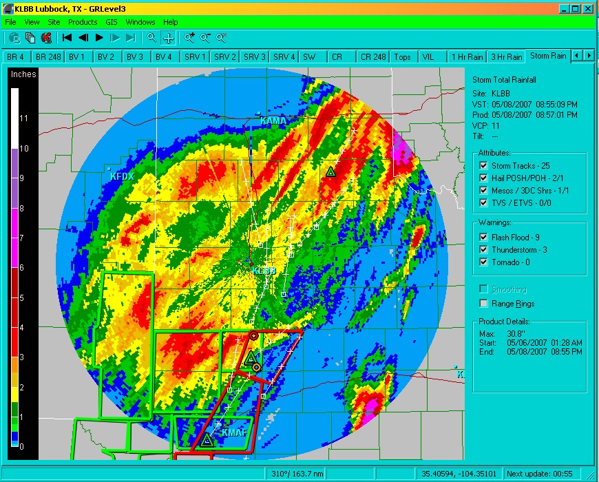
Von Lubbock TX bis Amarillo TX ( Midland County ) ...
Eine riesige Gewitterzelle hat sich in den Himmel geschossen wie ein Steinpilz.


Eine riesige Gewitterzelle hat sich in den Himmel geschossen wie ein Steinpilz.