Re: Sturmtief "Becky": 08.-10.11.2010
Verfasst: Di 9. Nov 2010, 15:01
Salü Gino
Ich weiss es jetzt .( bald )
http://elbanet.ethz.ch/wikifarm/wetter/ ... Main.Dis08
http://de.wikipedia.org/wiki/Polartief
http://de.wikipedia.org/wiki/Rossby-Welle
http://www.wetter3.de/antriebe.html
http://www.mi.uni-hamburg.de/Barokline-We.263.0.html
http://www.wetter3.de/temperaturadvektion.html
http://www.etymologie.info/~e/d_/de-wetter.html
http://www.diplomet.info/ROSSBY-Wellen.html
Major scale depression
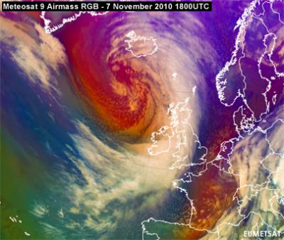
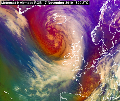
Affects the weather in Western-Europe and is seen in this Airmass RGB. This strong extratropical cyclone has a core pressure of 965 hPa, remarkably early for this time of the year. From a training perspective the image shows a wide range of conceptual models in the cold air behind the depression, such as cloud streets, open and close cell convection and a comma. The cold front itself gives the indication for a "split front" with the Airmass RGB showing that some dry air is moving over it. This in turn with a strong jet and a PVA maximum gives indication of line convection. A similar feature was also observed in Storm Emma and Kyrill. With the trough expanding south a red warning for high waves has been issued by AEMET for the Galician coast. The origin of this low is a baroclinic wave (RaCY) west of Greenland with an impressive 100 m/s upper jet streak. Be sure to also have a look at the images of 06 and 12UTC of 7 November!
Text Uebersetzt ( http://de.babelfish.yahoo.com/translate_txt )
Hauptskalatiefstand Beeinflußt das Wetter in Westlich-Europa und wird in dieses Airmass RGB gesehen. Dieser starke extratropical Wirbelsturm hat einen Kerndruck von hPa 965, bemerkenswert früh während dieser Zeit des Jahres. Von einer Trainingsperspektive, die das Bild eine große Auswahl der Begriffsmodelle in der Kaltluft hinter dem Tiefstand, wie Wolkenstraßen zeigt, und nahe Zellenkonvektion und ein Komma sich öffnend Sie. Die Kaltfront selbst gibt die Anzeige für ein " aufgeteiltes front" mit der Airmass RGB Vertretung, die etwas trockene Luft über es verschiebt. Dieses der Reihe nach mit einem starken Strahl und einem PVA Maximum gibt Anzeige über Linie Konvektion. Eine ähnliche Eigenschaft wurde auch im Sturm Emma und Kyrill beobachtet. Mit dem erweiternsüden der Abflussrinne ist eine rote Warnung für hohe Wellen durch AEMET für die galizische Küste herausgegeben worden. Der Ursprung dieses Tiefs ist eine baroclinic Welle (anzüglich) westlich von Grönland mit einem eindrucksvollen 100 m/s oberen Strahlenstreifen. Seien Sie sicher, einen Blick an den Bildern von 06 und von 12UTC von 7. November auch zu haben!
Gruss Urbi
.
Ich weiss es jetzt .( bald )
http://elbanet.ethz.ch/wikifarm/wetter/ ... Main.Dis08
http://de.wikipedia.org/wiki/Polartief
http://de.wikipedia.org/wiki/Rossby-Welle
http://www.wetter3.de/antriebe.html
http://www.mi.uni-hamburg.de/Barokline-We.263.0.html
http://www.wetter3.de/temperaturadvektion.html
http://www.etymologie.info/~e/d_/de-wetter.html
http://www.diplomet.info/ROSSBY-Wellen.html
Major scale depression
Affects the weather in Western-Europe and is seen in this Airmass RGB. This strong extratropical cyclone has a core pressure of 965 hPa, remarkably early for this time of the year. From a training perspective the image shows a wide range of conceptual models in the cold air behind the depression, such as cloud streets, open and close cell convection and a comma. The cold front itself gives the indication for a "split front" with the Airmass RGB showing that some dry air is moving over it. This in turn with a strong jet and a PVA maximum gives indication of line convection. A similar feature was also observed in Storm Emma and Kyrill. With the trough expanding south a red warning for high waves has been issued by AEMET for the Galician coast. The origin of this low is a baroclinic wave (RaCY) west of Greenland with an impressive 100 m/s upper jet streak. Be sure to also have a look at the images of 06 and 12UTC of 7 November!
Text Uebersetzt ( http://de.babelfish.yahoo.com/translate_txt )
Hauptskalatiefstand Beeinflußt das Wetter in Westlich-Europa und wird in dieses Airmass RGB gesehen. Dieser starke extratropical Wirbelsturm hat einen Kerndruck von hPa 965, bemerkenswert früh während dieser Zeit des Jahres. Von einer Trainingsperspektive, die das Bild eine große Auswahl der Begriffsmodelle in der Kaltluft hinter dem Tiefstand, wie Wolkenstraßen zeigt, und nahe Zellenkonvektion und ein Komma sich öffnend Sie. Die Kaltfront selbst gibt die Anzeige für ein " aufgeteiltes front" mit der Airmass RGB Vertretung, die etwas trockene Luft über es verschiebt. Dieses der Reihe nach mit einem starken Strahl und einem PVA Maximum gibt Anzeige über Linie Konvektion. Eine ähnliche Eigenschaft wurde auch im Sturm Emma und Kyrill beobachtet. Mit dem erweiternsüden der Abflussrinne ist eine rote Warnung für hohe Wellen durch AEMET für die galizische Küste herausgegeben worden. Der Ursprung dieses Tiefs ist eine baroclinic Welle (anzüglich) westlich von Grönland mit einem eindrucksvollen 100 m/s oberen Strahlenstreifen. Seien Sie sicher, einen Blick an den Bildern von 06 und von 12UTC von 7. November auch zu haben!
Gruss Urbi
.

