Seite 3 von 21
Re: FCST: Stürmische Woche 50 (Sturm JOACHIM 16.12.2011)
Verfasst: Fr 16. Dez 2011, 06:49
von Stefan Hörmann
Janine hat geschrieben:Dann hol ich meine Pflanzen wohl doch lieber mal vom Fenstersims runter...
Bin jedenfalls gespannt, obs wirklich so heftig wird wie prognostiziert. Ich kann mich nur an das halten, was ihr im Forum schreibt und Meteo Schweiz und Co sagt. Meine Gabe Wetterkarten zu lesen ist leider gleich null


Einfach auch auf das innere Gefühl hören, sich selbst entscheiden und nicht andere am eigenen Wohl oder Unwohl beteiligen. Das kann unsere Gesellschaft ja gut, eigene Verantwortung auf andere (Dienstleister) abzuwälzen. Eigentlich ist alles gesagt, wenn die Wetterdienste von schwerem Sturm und Orkan reden. Dann sollte man eigentlich Wissen, was zu tun und was zu lassen ist.
Re: NOW: Sturm JOACHIM 15./16.12.2011
Verfasst: Fr 16. Dez 2011, 07:09
von David(Goms)
Im Oberwallis grossflächig anhaltend mässiger- und nun auch starker Schneefall bis ganz runter (600müM.). Wird wohl noch ein Weilchen so sein...
Re: NOW: Sturm JOACHIM 15./16.12.2011
Verfasst: Fr 16. Dez 2011, 07:14
von Stefan Hörmann
David(Goms) hat geschrieben:Im Oberwallis grossflächig anhaltend mässiger- und nun auch starker Schneefall bis ganz runter (600müM.). Wird wohl noch ein Weilchen so sein...
Bettmeralp-Webcam schaut nach 20-30cm Neuschnee während der Nacht aus. Wenns ins Tal schneit, wie oft im Wallos bei Warmfronten, dann ist der Betrag der Verdunstungsabkühlung sowie Entzug von Schmelzwärme voll am Anschlag. Bin gespannt wie lange es gut geht. Die 2000m-Temperatur geht noch bis gegen 1-2 Grad hoch im Warmsektor, mit dem auch in den nächsten Stunden die Warmluft voll bis zum Boden durchgepulst wird. Übrigens: Dry Slot noch immer gut ausgeprägt. Könnte das für eine etwas stärkere Entwicklung sprechen?
Re: NOW: Sturm JOACHIM 15./16.12.2011
Verfasst: Fr 16. Dez 2011, 07:19
von Beni Grenchen
Am Jura (Grenchenberg) liegt die Schneefallgrenze noch bei rund 1150müM. Auf 1300müM -0.2 Grad und seit Stunden Starkschneefall. 20mm von 22:00 bis 5:00. Mal schauen wie hoch sie heute noch steigt.
Fahy: 112km/h Böe
Grenchen: 93km/h Böe
Re: NOW: Sturm JOACHIM 15./16.12.2011
Verfasst: Fr 16. Dez 2011, 07:31
von crosley
Quelle:
http://www.infoclimat.fr/cartes/radar_1h.gif
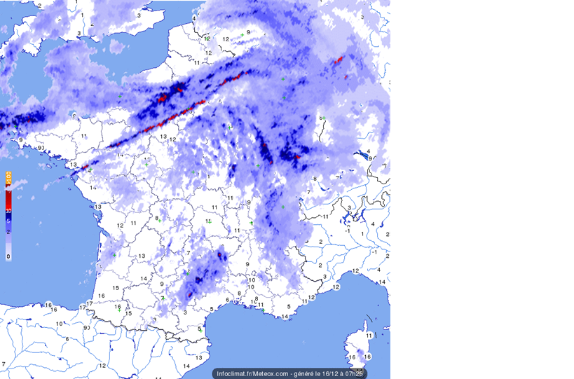
Zeigt das Regenband in Nordwestfrankreich bereits die Kaltfront?
Hier lässt sich Joachim schön beobachten:
http://www.meteociel.fr/observations-meteo/isos.php
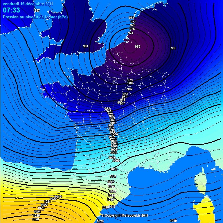
Grüsse Crosley
Re: NOW: Sturm JOACHIM 15./16.12.2011
Verfasst: Fr 16. Dez 2011, 07:54
von raffitio
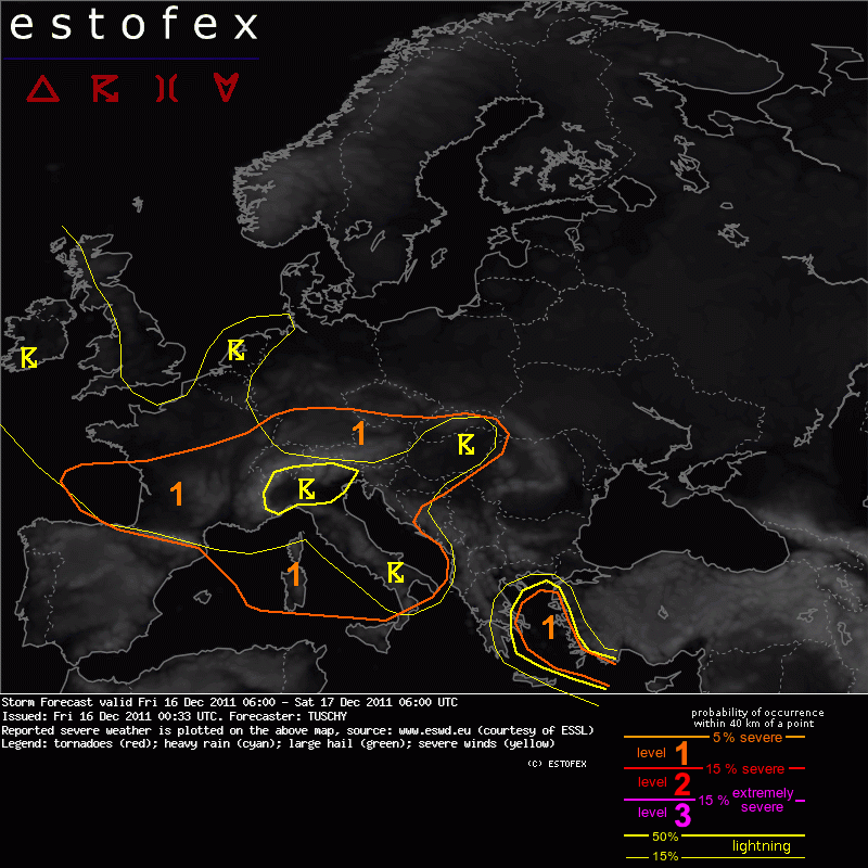
Estofex hat in seinem aktuellen Bericht die Lage betreffend der Kaltfront ausführlich erklärt:
DISCUSSION
... France, Switzerland, Germany, Austria, Hungary and Slovakia...
We expect no DMC within the broad warm sector of that low, supported by forecast sounding data given deep WAA regime. This may keep the most extreme wind gusts off the surface.
The focus then shifts to the cold front, which is aligned in a more SW-NE manner over France and more from N-S over S-Germany and NE-Austria. Strong dynamics and rapid cooling of the mid-levels may assist in a forced line (probably LEWP-like) of convection along the cold front, which races SE-wards (S-France) and E-wards (S-Germany). However at least over S-Germany the structure of that cold front does not look so impressive right now as does the pressure tendency field in the model field. Nevertheless, not much mixing will be needed to bring damaging wind gusts down to the surface as winds at 850 hPa remain in the range of roughly 30 m/s. Any line-up of convection (even short-line segments) will be able to produce similar wind gusts at the surface! Also, some moisture pooling along that front is still forecast, which may assist in enough LL CAPE for an isolated tornado event. We excluded S-Germany and parts of Austria from a thunderstorm area, as BL moisture seems to be very sparse in forecast model fields. Hence, confidence in electrified convection is limited. However, this does not limit the risk of damaging surface wind gusts as described above.
Of some concern is also an area, covering Hungary and Slovakia during the evening hours onwards. As the cold front approaches from the west, it taps into better moisture, which becomes advected from the N-Adriatic Sea/NE Italy. Some discrepancies exist regarding timing and placement of that front/moisture tongue overlap, but this configuration may result in better prefrontal CAPE build-up. Hence the low prob. thunderstorm area was expanded well to the NE. With diffuse forcing and a messy wind field, coverage of thunderstorms remains questionable. Strong to severe wind gusts will be the primary hazard.
Quelle: estofex.org
Re: NOW: Sturm JOACHIM 15./16.12.2011
Verfasst: Fr 16. Dez 2011, 07:55
von Silas
Hallo zäme
Hier war es bis 2 Uhr meist windstill, seither haben wir einen Mittelwind von knapp 15 km/h mit Böen bis 39 km/h.
Imposant der Druckfall: Zurzeit noch 997,2 hPa, um Mitternacht, also vor nicht einmal acht Stunden, waren es noch 1011,9 hPa und gestern um 20 Uhr noch über 1016 hPa!
Dazu eine Niederschlagssumme von bis anhin 0,6 mm...
Gruss Silas
Re: NOW: Sturm JOACHIM 15./16.12.2011
Verfasst: Fr 16. Dez 2011, 07:58
von Jacques_4625
Läck isch das es Sauwätter

Hatte eben das zweifelfafte Vergnügen, zu Fuss an den Bahnhof gehen zu dürfen. Fazit: Ja, Kollege Joachim ist da und ich bin klitschnass - von allen Seiten...
Zentrum z.Z. in etwa über Gent (Belgien) mit 967.7 hPa
http://www.weatherlink.com/map.php?station=taperkins
Re: NOW: Sturm JOACHIM 15./16.12.2011
Verfasst: Fr 16. Dez 2011, 08:00
von David(Goms)
@Stefan Hörmann
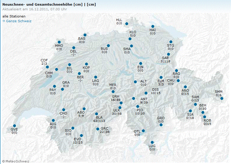
Im Oberwallis sind die Neuschneemengen deutlich höher als 20cm-30cm:
Fiesch: 41cm
Blatten im Lötschental: 63cm
Auf der Bettmeralp dürfte es ebenfalls bereits gegen 50cm Neuschnee sein.
Webcams (dort liegt nur Neuschnee):
http://albenried.ch/webcamimages/snapshot.jpg
http://www.mauracker.ch/webcam/live.jpg
Auf 2000m wird es im Bereich Aletschgebiet/Goms heute kaum auf +1°C bis +2°C kommen - im Unterwallis aber schon. Ich rechne nochmals mit 50cm Neuschnee ab 1300m.
Hier noch die MM-Vorhersage für die Riederalp (2000m):
http://wetterstationen.meteomedia.de/me ... 1324015807
Re: NOW: Sturm JOACHIM 15./16.12.2011
Verfasst: Fr 16. Dez 2011, 08:00
von Michi, Uster, 455 m
Blatten, Lötschental 1500 m 63 cm Neuschnee, da werden einige Touristiker eifersüchtig...
Quelle:
http://www.meteoschweiz.admin.ch/web/de ... Stations=1
Bettmeralp in Hochlaune:
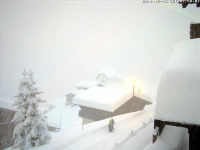
Quelle:
http://www.bettmeralpbahnen.ch/graphics ... m7huge.jpg
