Absterbender, präfrontaler Komplex aus Frankreich mit Neubildungen an dessen Vorderseite (analog der jetzigen Jurazelle). Ich schrieb vom Sat- und Radarbild her. Damals war allerdings alles eine Dimension kräftiger.Was ist den gleich, wie am Montag? Das was ich als Laiin gerde sehe und beobachte macht mir nicht den Eindruck als sei allzuviel gleich....

Werbung
Gewitter 23.08.2012
-
Andreas -Winterthur-

- Beiträge: 4383
- Registriert: Do 19. Jul 2012, 07:38
- Hat sich bedankt: 339 Mal
- Danksagung erhalten: 598 Mal
Re: Gewitter 23.08.2012
“Some people are weather wise, but most are otherwise” Benjamin Franklin
-
crosley

- Moderator
- Beiträge: 1938
- Registriert: Fr 13. Aug 2004, 15:48
- Geschlecht: männlich
- Wohnort: 5000 Aarau
- Hat sich bedankt: 419 Mal
- Danksagung erhalten: 386 Mal
- Kontaktdaten:
Re: Gewitter 23.08.2012
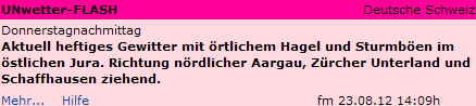
Alfred's 2 ist da!
Gehört hier noch rein, auch wenn es von mir zurzeit sonst keine Eigenleistung im Bezug auf das Wettertechnische gibt:
Quelle: http://www.estofex.org
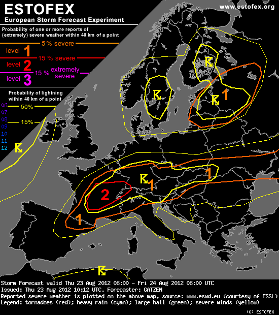
Storm Forecast
Grüsse Crosley
Gehört hier noch rein, auch wenn es von mir zurzeit sonst keine Eigenleistung im Bezug auf das Wettertechnische gibt:
Quelle: http://www.estofex.org
Storm Forecast
Valid: Thu 23 Aug 2012 06:00 to Fri 24 Aug 2012 06:00 UTC
Issued: Thu 23 Aug 2012 10:12
Forecaster: GATZEN
A level 2 was issued for south-eastern France and the western Alpine region mainly for very large hail.
A level 1 was issued for south-eastern France mainly for tornadoes.
A level 1 was issued for southern and eastern France, the Alpine region, northern Italy, the northern Balkans, southern Germany, the Czech Republic, southern Poland, and southern Ukraine mainly for large hail, severe wind gusts, and excessive precipitation.
A level 1 was issued for the Baltic States and north-western Russia mainly for tornadoes.
SYNOPSIS
Low geopotential across the north-eastern Atlantic and Scandinavia yields a westerly jet stream extending across central Europe. An intense short-wave trough currently over Poland will travel into western Russia today. Another short-wave trough will follow reaching the Bay of Biscay in the afternoon hours.
At lower levels, a well-developed frontal boundary stretches from the Bay of Biscay to southern Germany and northern Ukraine.
DISCUSSION
South-eastern France and Alpine region into southern Ukraine
Latest soundings indicate steep lapse rates across the region due to well-mixed mid levels. The boundary-layer is quite moist along the frontal boundary, while moisture is increasing to the west, where more than 14 g/kg mixing ratio is present in the lowest kilometer. As a consequence, a broad field of positive CAPE is observed. Daytime heating will likely result in moderate to relatively high MLCAPE values of 800 to 2000, locally more than 2500 Jkg.
Through-out the period, strong mid-level westerly winds will be present with about 15 to 20 m/s at 500 hPa in the south and 25 m/s in the north of the area, associated with 0-6 km deep layer vertical wind shear between 15 and 25 m/s. Additionally, strong westerly winds at 700 hPa will lead to 0-3 km vertical wind shear of 10 to 20 m/s. With weak south-easterly low-level winds, favorably veering profiles are expected especially to the north of the Alps, where 0-3 km SRH is expected to reach 150-250 m²/s² in the afternoon hours.
During the day, warm air advection is expected to spread eastward along the frontal boundary ahead of the approaching trough. First elevated thunderstorms have already formed across southern France in the morning hours. Main activity is expected in the afternoon and evening hours from the Massif Central to the western Alps. Given the QG forcing, storms may merge into an MCS moving north-eastwards into south-western Germany in the evening and night hours. Additional storms are expected to form over the Alps through-out the period as well as from Austria to the souhern Ukraine. In the afternoon, convective activity is forecast to spread also into the northern Alpine region as well as into northern Italy and surroundings. Also southern France may see some storms.
The main convective mode will be multicells with the chance of large hail in the southern parts of the risk area and supercells with a chance of large hail further north given the favorably veering profiles. Supercells will be capable of producing very large or even giant hail across central and eastern France. Very large hail may be also possible from southern Germany into Austria in the evening hours. Additionally, supercells are forecast to be capable of producing tornadoes from southern France into south-western Germany given an increasing low-level jet in the warm air advection regime. Latest GFS model indicates south-westerly winds exceeding 15 m/s at 850 hPa in the evening hours, when the threat is expeced to be most pronounced. However, it seems that convection will gradually merge into an MCS and the tornado threat is expected to decrease, whereas severe winds become more likely.
Thunderstorms are forecast to go on during the night hours spreading into southern and central Germany along the warm front. The severe threat will gradually decrease, but severe winds and locally excessive rain and large hail are not ruled out...
Grüsse Crosley
-
flowi
- Beiträge: 1263
- Registriert: Mo 2. Mai 2011, 14:32
- Hat sich bedankt: 1793 Mal
- Danksagung erhalten: 1194 Mal
Re: Gewitter 23.08.2012
Hoi Alfred,Alfred hat geschrieben:Flower, es gibt power!
grad kann ich es eigentlich brauchen.
Wollte grade anfangen Fundamente für neue Außentreppe zu betonieren ...
Aber vielleicht schwächelt sie ja noch rechtzeitig
Gruß
Flower
Zuletzt geändert von flowi am Do 23. Aug 2012, 14:48, insgesamt 1-mal geändert.
-
Bulilu
- Beiträge: 238
- Registriert: Do 16. Aug 2012, 10:32
- Geschlecht: weiblich
- Wohnort: Suhr
- Hat sich bedankt: 31 Mal
- Danksagung erhalten: 23 Mal
Re: Gewitter 23.08.2012
Äähh whatAlfred hat geschrieben:Flower, es gibt power!
-
pasischuan

- Beiträge: 728
- Registriert: Mi 1. Dez 2010, 07:03
- Geschlecht: männlich
- Wohnort: 3608 Thun
- Hat sich bedankt: 71 Mal
- Danksagung erhalten: 115 Mal
Re: Gewitter 23.08.2012
Off TopicWir kennens dieses Jahr ja nicht andersBulilu hat geschrieben:@ Pasi: Sieht ganz danach aus, als ob die Zelle vor Thun wieder verhungertSo ne Ungerechtigkeit für Euch
aber eben.. gibt bessere und schlechtere Jahre.. und dieses Jahr gehört Gewittertechnisch definitv zu den schlechteren.. nicht nur für Thun sondern ich glaube ich darf hier für das ganze Aaretal sprechen..
Thun, Allmendingen (BE), 580 m.ü.M.
-
Bulilu
- Beiträge: 238
- Registriert: Do 16. Aug 2012, 10:32
- Geschlecht: weiblich
- Wohnort: Suhr
- Hat sich bedankt: 31 Mal
- Danksagung erhalten: 23 Mal
Re: Gewitter 23.08.2012
Wo beginnt und endet für dich das Aaretal??pasischuan hat geschrieben:Off TopicWir kennens dieses Jahr ja nicht andersBulilu hat geschrieben:@ Pasi: Sieht ganz danach aus, als ob die Zelle vor Thun wieder verhungert
-
Thomas, Belp
- Beiträge: 1931
- Registriert: Mo 17. Mär 2008, 21:40
- Geschlecht: männlich
- Wohnort: 3123 Belp BE
- Hat sich bedankt: 60 Mal
- Danksagung erhalten: 37 Mal
Re: Gewitter 23.08.2012
Off Topic
@Bulilu: Im Kanton Bern würde ich meinen liegt das Aaretal zwischen Thun und Bern.
Oberhalb des Brienzersees (sicher aber oberhalb Meiringen) eher Haslital. Und dann beanspruchen ja auch die Aargauer noch ein Aaretal...
Thomas, Belp BE (517 M.ü.M) Gürbe-/Aaretal
-
pasischuan
- Beiträge: 728
- Registriert: Mi 1. Dez 2010, 07:03
- Geschlecht: männlich
- Wohnort: 3608 Thun
- Hat sich bedankt: 71 Mal
- Danksagung erhalten: 115 Mal
Re: Gewitter 23.08.2012
Off Topic
Wo beginnt und endet für dich das Aaretal??
Hm... Also gemäss Quelle: Wikipedia.com
"Zwei Regionen werden häufiger als Aaretal im engeren Sinne bezeichnet: Das Tal der Aare zwischen Bern und Thun sowie das Tal der Aare im Kanton Aargau."
Ich meine natürlich erstgenanntes

Gruss Pasi
Zuletzt geändert von pasischuan am Do 23. Aug 2012, 15:06, insgesamt 3-mal geändert.
Thun, Allmendingen (BE), 580 m.ü.M.
-
Federwolke

- Moderator
- Beiträge: 9499
- Registriert: Mo 20. Aug 2001, 23:47
- Geschlecht: weiblich
- Wohnort: 3074 Muri bei Bern
- Hat sich bedankt: 1906 Mal
- Danksagung erhalten: 9488 Mal
- Kontaktdaten:
Re: Gewitter 23.08.2012
Jaja, nichts ist mehr wie früher (in der Saison). Der Sommer wird altersmilde: Potenzielle Superzellen teilen sich nicht mehr, scheren nicht nach rechts aus und verhungern bereits nach einer Stunde. Aber wenn ein wichtiger Kunde genau unter der möglichen Zugbahn sitzt und ohne Vorwarnung getroffen wird, hat er keine Freude. Also besser einmal zu viel warnen als zu wenig.Bulilu hat geschrieben:Äähh whatAlfred hat geschrieben:Flower, es gibt power!
Das Ding macht mir eher einen harmlosen Eindruck
Aber das Ding kann sich jetzt am Südhang des Schwarzwalds wunderbar generieren. Werden sich andere drüber freuen
Zuletzt geändert von Federwolke am Do 23. Aug 2012, 15:07, insgesamt 1-mal geändert.
Grüsslis
Fabienne (Muri bei Bern, 560 m)
https://www.fotometeo.ch
https://www.orniwetter.info
https://fotometeo.smugmug.com
https://bsky.app/profile/fotometeo-ch.bsky.social
Fabienne (Muri bei Bern, 560 m)
https://www.fotometeo.ch
https://www.orniwetter.info
https://fotometeo.smugmug.com
https://bsky.app/profile/fotometeo-ch.bsky.social
Re: Gewitter 23.08.2012
schon wieder alles vorbei?.. hab ich etwa für so einen minigutsch Wasser alles eingeräumt?
@ Pasi : dankeschön. off topic <Bin eigentlich mehr stiller Beobachter und mag viel lieber schönes Wetter ( also das mit Sonne ) Den ganzem Winter über wolltest Du Schnee und ich war froh gabs keinen Aber jetzt wäre ich bald wirklich um richtig Regen - gibt doch nichts reinigenderes als ein schönes Sommergewitter..... 
Allerdings kann einem selbst dies an so einem Ort wie meinem verleiden: ständig muss ich beim kleinsten Regen alles anbinden damit es nicht "wegluftet" . Bald mach ich auf der Gemeinde einen Antrag auf Strassennamenänderung in " Windböeneck"... > off topic Ende
LG Patty
@ Pasi : dankeschön. off topic <Bin eigentlich mehr stiller Beobachter und mag viel lieber schönes Wetter ( also das mit Sonne ) Den ganzem Winter über wolltest Du Schnee und ich war froh gabs keinen
Allerdings kann einem selbst dies an so einem Ort wie meinem verleiden: ständig muss ich beim kleinsten Regen alles anbinden damit es nicht "wegluftet"
LG Patty