Re: Sturmfront/Gewitter 30.07.2026 + 31.07.2026
Verfasst: Fr 31. Jul 2026, 09:28
Estofex hat für Heute einen Level 1:
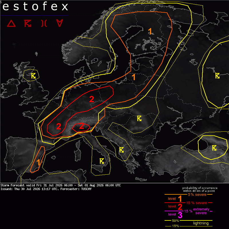
Allerdings ist das Ganze mit einer guten Portion Unsicherheit zu geniessen:A level 2 was issued for parts of CNTRL/E France mainly for very large hail, severe gusts and heavy rain.
A level 2 was issued for parts of N Italy mainly for hail, damaging gusts and heavy rain.
A level 2 was issued for parts of Germany into NW Poland mainly for damaging gusts.
A level 1 surrounds all level 2 areas for similar hazards with lowered probabilities (hail, gusts, heavy rain). An isolated tornado is possible over NW Germany and over Finland.
A level 1 was issued for E Spain mainly for isolated hail and gusts.
SYNOPSIS
A static pattern features a NE ward aligned ridge from S towards E Europe, which faces a trough over NW Europe. A strong frontal zone covers most of W to NE Europe and is accompanied by a wavy frontal boundary. Progressive short waves, which cross this boundary serve as foci for organized DMC activity from France to Finland.
Auch die Uneinigkeit in den Modellen spricht Heute für Nowcast.!! We issued broad level areas to account for uncertainties in self induced long-lived and cold pool driven convection. Some areas see less activity, whereas others could see higher severe probabilities than currently highlighted (e.g. Switzerland to S Germany and NW Germany). Nowcast will be important for today's event as only marginal shifts in activity could result in substantial shifts of severe maxima. !!


 ) mercivielmol..