Seite 5 von 8
Re: NOW: Unwetter, 14.07.2010
Verfasst: Mi 14. Jul 2010, 00:52
von Michi, Uster, 455 m
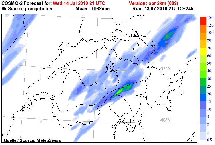
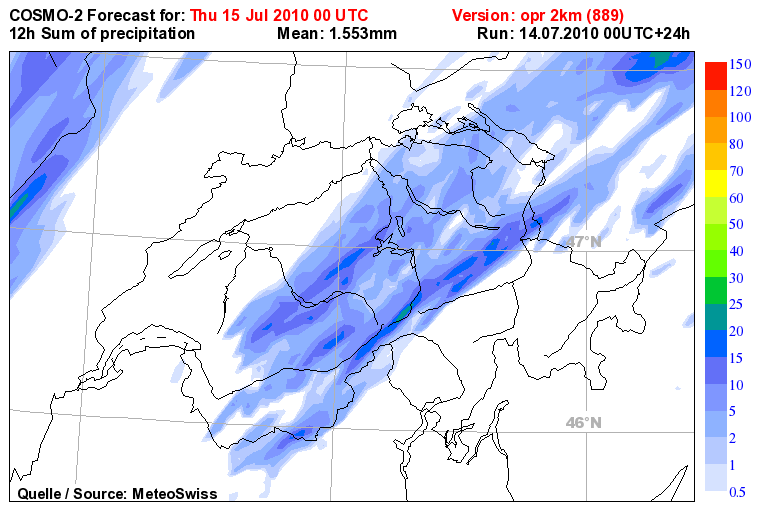
Hier noch der neuest Cosmo2-Lauf mit Auslöse in den Alpen, nix Föhn, Mittelland/Jura wird ausgelassen:
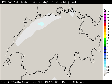
Und was noch interessanter ist, Ukmo Nae erfasst die Nachtschauer:
Re: NOW: Unwetter, 14.07.2010
Verfasst: Mi 14. Jul 2010, 00:57
von Maximilian.K (Bern)
was denkt ihr ? Wann gibt Meteocentrale die ersten Vorwarnungen raus ?
EDIT: Estofex hat nun Update gemacht
http://www.estofex.org/ liege wahrscheinlich ganz knapp im lvl 2
na mal sehen was morgen kommt
Re: NOW: Unwetter, 14.07.2010
Verfasst: Mi 14. Jul 2010, 01:20
von Badnerland
Sali,
Estofex gibt dieses mal direkt das Level 3 für Benelux / Nordwestdeutschland und die 2 für den Nordwestrand der Schweiz sowie die komplette Westhälfte Deutschlands:
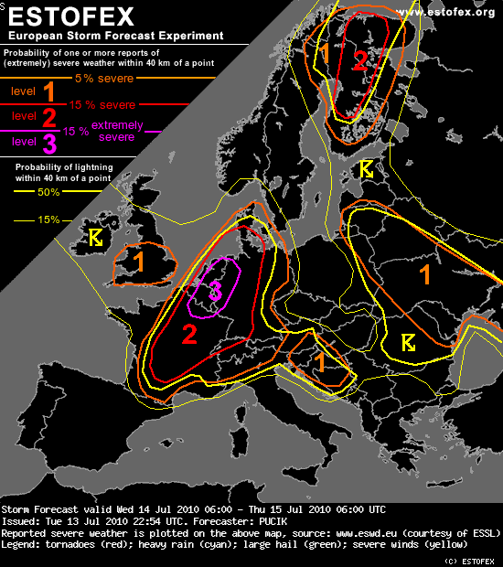
Storm Forecast
Valid: Wed 14 Jul 2010 06:00 to Thu 15 Jul 2010 06:00 UTC
Issued: Tue 13 Jul 2010 22:54
Forecaster: PUCIK
...
A level 2 was issued for Southern to Central France, extreme Northwestern Switzerland and Southern Germany mainly for large hail, severe wind gusts and to the lesser extent for excessive precipitation.
A level 1 was issued for the regions surrounding the Level 2 mainly for severe wind gusts, large hail and excessive precipitation.
...
SYNOPSIS
The main macro-synoptic feature at mid levels will be a trough with axis over the Eastern Atlantic, with an embedded cold-core low centered over Ireland by Wednesday 12 UTC, moving slowly to northeast. Strong flow surrounds the fringes of the trough with windspeeds up to 40 m/s at 500 hPa level. A short wave trough will translate with this flow in the evening and early night hours over Northern France, Benelux countries towards Scandinavia. To east, a large ridge will stretch from the Central Mediterranean, across much of Central Europe into Northwestern Russia.
At the surface a centre of the deep low will reside close to or over the British Isles. Its trough will extend with the frontal system to the southeast and will accelerate quickly eastwards during the day. Mesoscale low will probably form within the frontal wave over Benelux and might become a significant factor in scenario. Ahead of the frontal system, high Theta-E airmass is advected at lower levels to northeast.
...
DISCUSSION
... France, Benelux, Western half of Germany ...
***Potentially dangerous setup with severe weather outbreak is forecast over this region***
Ahead of the frontal zone, high Theta-E airmass is advected at lower levels and as cooler mid-level temperatures overspread this airmass a belt of moderate latent instability is forecast to form. Models are in fairly good agreement regarding the CAPE values, which should be mostly in the range of 1000-1500 J/kg.
With strong southerly to southwesterly flow aloft, high values of wind shear are forecast, with over 25 m/s of DLS and 20 m/s of MLS, values sufficient for very well organised convection, including supercells. With weak relative upper level flow, convection will probably tend to organise into quasi-linear system rathern than into long-lived supercells. Another factor speaking for such system is the orientation of the mid and upper level flow to the boundary, which is almost parallel and therefore, quick clustering is expected. Nevertheless, the possibility of isolated, steadier supercellular convection, especially in the earlier stages of scenario can not be discounted.
Forcing should be very favorable, in the form of the cold front and as the above mentioned short wave trough , which might induce or support cyclogenesis in the axis of the frontal trough. Such low would probably contribute to the backing of the surface winds (increasing SREH values) ahead of it and to the strenghtening wind field at lower levels. Models simulate 30 m/s 700 hPa flow during evening and night hours in the proximity and behind of the surface front.
With such strong wind field at lower levels, quickly travelling mid-level short wave trough and strong tendency for storm clustering, severe quasi-linear MCS might travel at high speeds to northeast along the front and produce a swath of severe wind gusts, including some gusts over 32 m/s. This will be the prime threat and Level 3 is issued especially for the area, where the passage of severe MCS is most probable. In the earlier stages, when isolated form of convection will prevail and over the southern parts of Level 2, large hail will be a threat, especially if supercells form. In that case, hailstones over 4 cm might be observed. Especially to the northwest of the mesoscale low, excessive precipitation might occur, at the northern end of large MCS with possibility of "train effect". With high effective PW values, at least short term excessive precipitation can not be ruled out elsewhere in Level 2. Last, but not least, tornadoes might occur and more so in the environemnt with higher SREH and LLS ahead of the mesoscale low and lower LCLs during the late evening and night hours - therefore BENELUX and Northwestern Germany will probably be the region with the highest probability of tornado occurence. The fact that the convection will tend to occur mostly in linear clusters limits the potential for tornadoes
...Eastern Germany, Northern Denmark, Alpine region...
As front progresses eastwards during the night hours, instability will diminish and become likely elevated but a slight chance for severe weather will still exist, especially as strong low level wind field will remain immediately behind the cold front.
To the south, isolated to scattered convection might form over Alpine region during the day and in moderate wind shear and instability, isolated large hail or isolated event of excessive precipitation is not ruled out.
Quelle:
http://estofex.org/cgi-bin/polygon/show ... recast.xml
Keraunos noch fix die grafische Übersicht (Text kommt wohl noch):
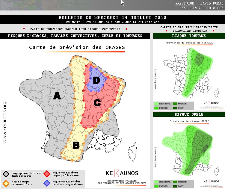
Quelle:
http://www.keraunos.org/prevision-orage ... utlook.htm
Gruss Benni
Re: NOW: Unwetter, 14.07.2010
Verfasst: Mi 14. Jul 2010, 01:30
von 221057Gino
Hallo zusammen
Nicht für mich aber für diejenigen
wo kein Wort englisch verstehen
hier im CHer SturmForum ...
Please übersetzen !
Thnx
Re: NOW: Unwetter, 14.07.2010
Verfasst: Mi 14. Jul 2010, 02:23
von nordspot
Hoi Gino, der Level 2 wird von den fexlern ausgegeben wegen Starkwind und Hagel, weniger wegen starkem Regen, ums kurz zu fassen...
Gutenacht Grüße
Ralph
Re: NOW: Unwetter, 14.07.2010
Verfasst: Mi 14. Jul 2010, 04:17
von Michi, Uster, 455 m
Herrlich erfrischende Duschen vorhin am Zürichberg! Bilanz 3 Schauer, total 2.8 mm. Jetzt ziehen diese nach Nordosten weg, im Westen praktisch wolkenlos und es geht wieder nach Plan weiter.
Die Cosmo 00z-Läufe sind eingetrudelt. Der Cosmo2-Lauf ist mein Favorit (ist auch nicht schwierig

)
Cosmo2 Mi12z-Do00z:
Cosmo7 Mi12z-Do00z:

Re: FCST: Unwetter, 14./15. Juli 2010
Verfasst: Mi 14. Jul 2010, 07:58
von Dani (Niederurnen)
Hier noch WRF, mit dem Alpenschwerpunkt am Nachmittag:
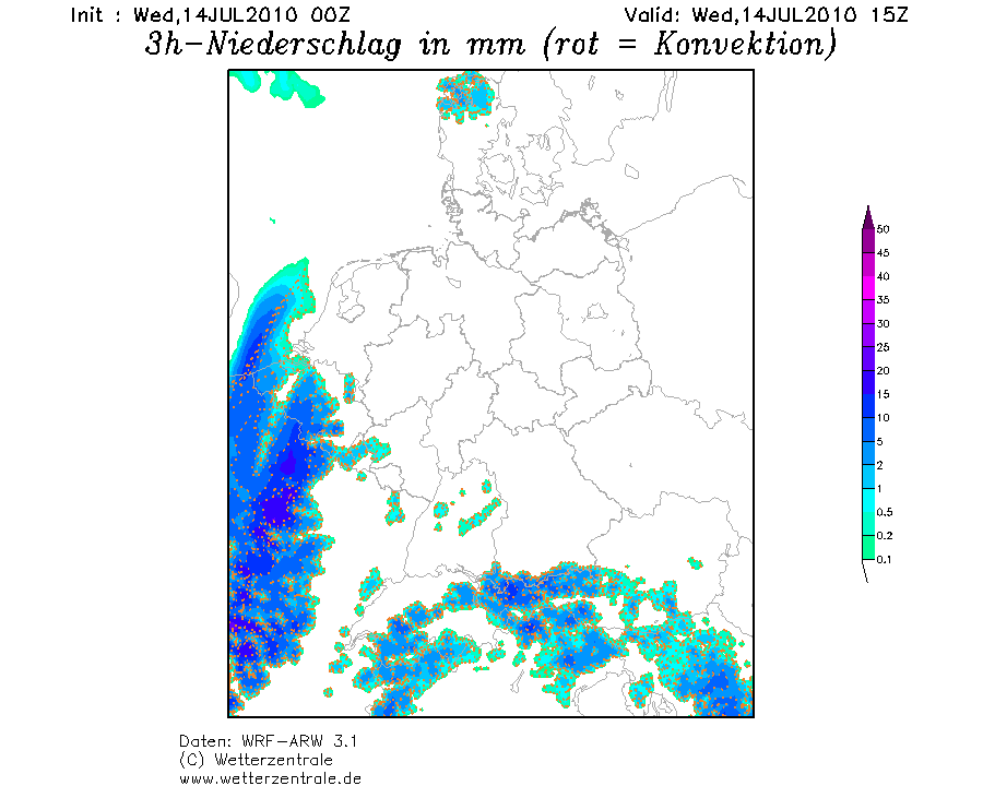
Und dem Westen am Abend:
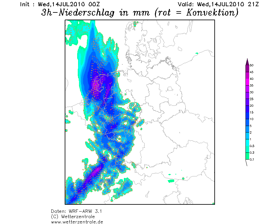
Hier würde die Ostschweiz die Nullnummer ziehen.
Etwas bedenklich stimmt mich das GFS weiterhin alles westlich der Schweiz hochzieht, wohl stark gerechnete SW Strömung.
Gruss Dani
Re: FCST: Unwetter, 14./15. Juli 2010
Verfasst: Mi 14. Jul 2010, 08:07
von Bernhard Oker
Sehr extreme Werte bei Taupunkt und LI/CAPE in der Ostschweiz gerechnet für heute 20 Uhr:

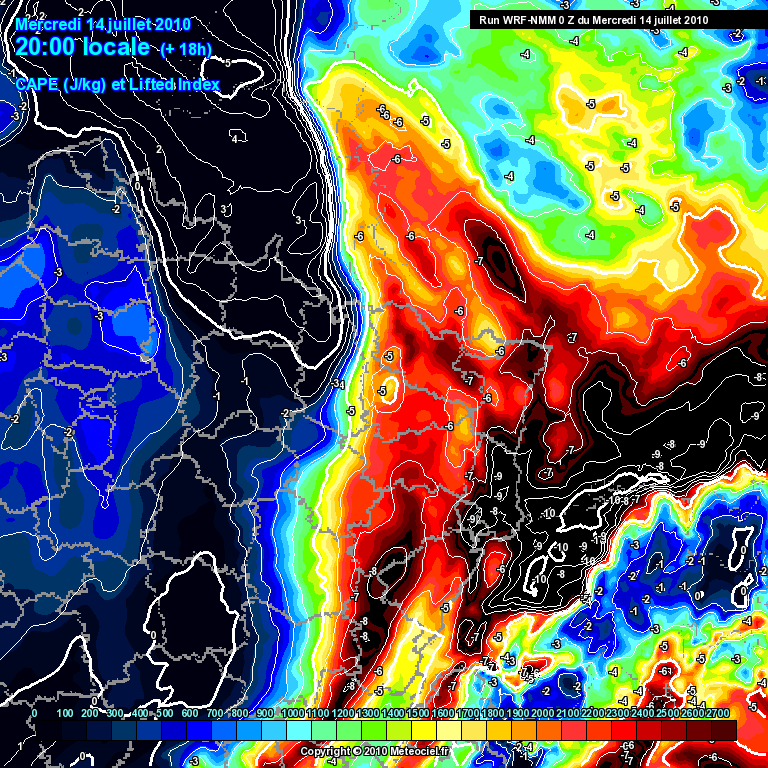
Quelle:
http://www.meteociel.fr/modeles/wrfnmm. ... de=7&map=2
Gruss
Bernhard
Re: NOW: Unwetter, 14.07.2010
Verfasst: Mi 14. Jul 2010, 08:35
von lukasm
Hallo
Hab hier wieder mal die einzelnen ENS verglichen ... und irgendwie scheint mir der Hauptlauf etwas aus dem Rahmen gelaufen zu sein ...

Es ist die kumulierte Regenmenge von heute Mittag bis morgen Mittag (das ganze ist natürlich mit der geringen Auflösung gerechnet!).
Und dann hab ich noch das ganze aus der anderen Ansicht geplottet, schon bei 20mm spielt hier nur noch der Hauptlauf mit. Klar, bei konvektiver Natur mag das weniger aussagekräftig sein, aber keine Bedeutung schenk ich dem auch nicht ...
Der weisse dicke Strich ist jeweils der Hauptlauf.

Gruess
Lukas
Re: FCST: Unwetter, 14./15. Juli 2010
Verfasst: Mi 14. Jul 2010, 09:10
von Tinu (Männedorf)
Guten Morgen
Auch noch ein paar Kärtchen meinerseits, weils so schön ist.
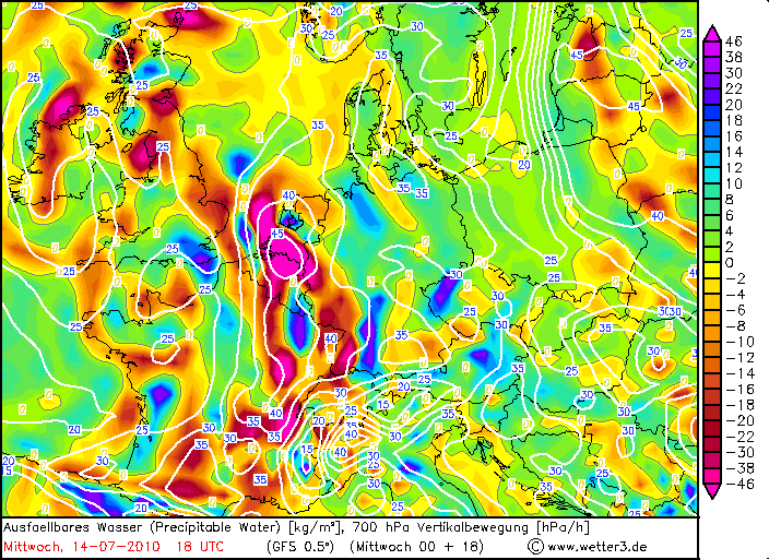
GFS zeigt zum Zeitpunkt 18 UTC im präfrontalen Bereich in einem langen Band verbreitet über 40 mm ausfällbares Wasser:
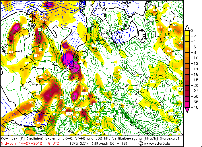
Dazu die höchsten Cape-Werte nördlich der Alpen über dem
Nordosten der Schweiz und BW, sowie weiträumig klar negative KO-Indices:

Die Front ist auf den ersten Blick (alp)traumhaft für diese Jahreszeit. Schade kommt das Ganze nicht einen Tick früher:
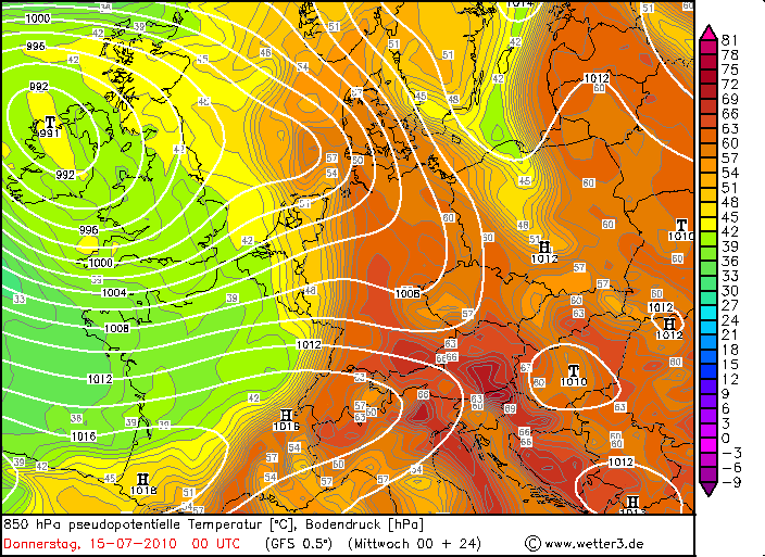
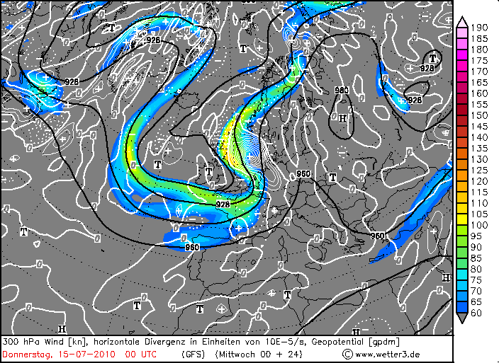
Auf den zweiten Blick relativiert sich das Ganze – aus Sicht eines Alpenländers – aber ein wenig. Wie @Christian bereits bemerkt hat, fehlt im Süden die Unterstützung durch den Jet (im Gegensatz zum Nordwesten). Im Süden verwellt die Front und wird m.E. sogar leicht rückläufig (kann mich in diesem Punkt aber auch täuschen). Dennoch von Norwegen bis Norditalien ein Plus bei der Horizontalen Divergenz:
Allerdings zeigt uns ja die Erfahrung, dass wir im Alpenraum im Hochsommer durchaus auch ohne eine direkte Frontpassage auskommen, in der Regel reicht es, wenn dadurch der Anschub erfolgt. Das Potenzial ist schon gewaltig, v.a. in der Ostschweiz. Schaun mer mal, obs auch abgerufen wird...