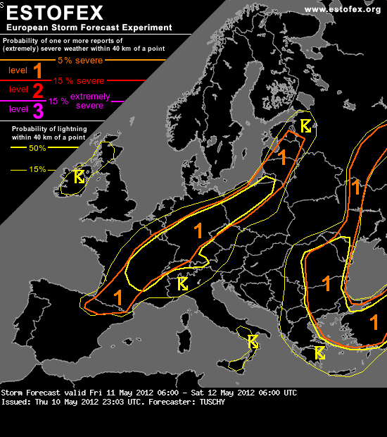
Werbung

Synop: Gewitter, 11./12.05.2012

Alles zu (Un)wetter relevant für die Schweiz
Necronom
Beiträge: 649
Registriert: Mo 24. Mär 2008, 14:54
Geschlecht: männlich
Wohnort: Bezirk Baden, Limmattal
Hat sich bedankt: 944 Mal
Danksagung erhalten: 403 Mal

Re: Synop: Gewitter, 11./12.05.2012

Beitrag von Necronom »

Hallo zusammen,

während Cosmo-2 keine Niederschläge schweizweit bis in die zweite Nachthälfte anzeigt (Quelle Landi.ch->Niederschlagsprogonose), hat WRF-NMM von Wetterinfo.ch schön früh eine Auslöse über dem Jura zu bieten mit Zugbahn Richtung Aargau:
Bild
Quelle: http://www.wetterinfo.ch
Wäre ein Volltreffer für meine Region.
Also noch sehr unterschiedliche Signale welche diese Modelle von sich geben. Leider habe ich keine weitere Zeit mich mit dem Thema zu vertiefen, die Arbeit ruft.
Freue mich auf viele spannende und aufklärende Beiträge unserer Experten auf dem Forum.
Wünsche einen angenehmen Tag.

Gruess us Bade.
Zuletzt geändert von Necronom am Fr 11. Mai 2012, 09:07, insgesamt 1-mal geändert.

Benutzeravatar
Microwave
Beiträge: 1232
Registriert: Mo 2. Aug 2010, 22:31
Geschlecht: männlich
Wohnort: 8004 Zürich
Hat sich bedankt: 2727 Mal
Danksagung erhalten: 230 Mal

Re: Synop: Gewitter, 11./12.05.2012

Beitrag von Microwave »

Lasst mich raten - WRF übertreibt's wohl mal wieder ganz doll!

Skeptische Grüsse - Microwave ;)
Successful corepunches during (GA) "chasing":
11, 6, 0
5, 0


Benutzeravatar
crosley
Moderator
Beiträge: 1934
Registriert: Fr 13. Aug 2004, 15:48
Geschlecht: männlich
Wohnort: 5000 Aarau
Hat sich bedankt: 410 Mal
Danksagung erhalten: 362 Mal
Kontaktdaten:

Re: Synop: Gewitter, 11./12.05.2012

Beitrag von crosley »

Hallo Zusammen!

Das Forecast von estofex.org , darf natürlich hier nicht fehlen:
Bild
Storm Forecast
Valid: Fri 11 May 2012 06:00 to Sat 12 May 2012 06:00 UTC
Issued: Thu 10 May 2012 23:03
Forecaster: TUSCHY
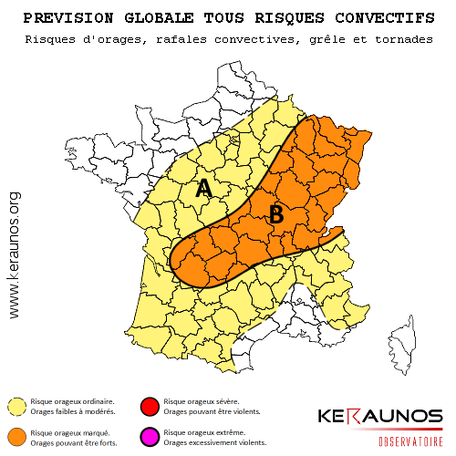
A level 1 was issued for France, Germany, parts of Belgium, Luxembourg, parts of Switzerland and parts of Poland mainly for large hail, severe wind gusts and heavy to excessive rainfall.

A level 1 was issued for W-Turkey, parts of Greece, Bulgaria, Romania, Moldova, C-Ukraine and northwards mainly for isolated large hail, strong to isolated severe wind gusts and heavy rainfall.

A level 1 was issued for NE Poland to Estonia mainly for a few tornado events and strong to isoalted severe wind gusts.

SYNOPSIS

A potent upper trough over Ireland and Scotland shifts to the east during the forecast, retaining its positive tilt. With no new upstream impulse and/or incoming jet max expected, only a slow shift to the south and marginal amplification to the SW of the upper trough are forecast with strongest jet core placed along its eastern fringe (e.g. S-North Sea, Denmark and S-Baltic Sea). Deep WAA downstream still sustains the strong ridge over SW/C-Europe with a weakening trend seen during the end of the forecast. An ill defined cut-off low over E/SE Europe sparks numerous showers/thunderstorms.

At the surface, a SW/NE aligned cold front is situated in the W/C-European level 1 with a slow progression towards the SE. A diurnal strengthening cycle of this front is forecast.

DISCUSSION

... France, S-Belgium, Luxembourg, Switzerland, Germany and NW-Poland ...

The crude time table is clear with the SE-ward progression of an ana cold front and attendant prefrontal wind shift, crossing C-France/Germany during peak heating and approaching S-France/Switzerland and S-Germany during the night hours.

The main concern will be timing and degree of thunderstorm initiation along that front. Until 15-18Z, no real disturbance at mid-/upper levels is embedded in this straight SW-erly flow regime as positive tilted main trough over UK slowly approaches from the NW. At that time, the surface front is also displaced well to the south of the upper jet core. During the night hours, the SE-ward advancing cold front gradually slows down, which assists in a slow catch-up of the mid/upper jet and the front itself. Also during the evening/night, some weak PVA maxima can be detected over C/N- France with a slight increase in strength during their NE-ward progression along that SW-NE aligned cold front.

All that said, initiation until 15 Z will be probably strongly linked to local orography support or the transgression of the convection temperature. Also, strong frontogenesis with the main cold front is underway between noon and afternoon with robust prefrontal heating (good insolation forecast) and the set-up of a prefrontal weak thermal low pressure channel, which results in stronger backing and better LL convergence. Also, due to ongoing frontogenesis, the direct thermal circulation strengthens, which may also assist in initiation. Then, BL moisture piling over Luxembourg and just to the south is forecast, which may be the result of a modest SW-erly LLJ and better LL moisture advection between the Jura and Vosges Mountains to the N/NE, probably increasing LL convergence. Finally, aforementioned prefrontal wind shift may also serve as focus for isolated initiation. This boundary seems to be best structured over C/E-Germany.

Mixing all that into one forecast, we think that initiation over NE France, Luxembourg and parts of Belgium during late forenoon or around noon is likely with a rapid E/NE-ward progression and increase in coverage and strength. Isolated/discrete activity (mainly linked to the topography and the aforementioned prefrontal wind shift) also evolves over C/E-Germany during the early afternoon hours onwards.
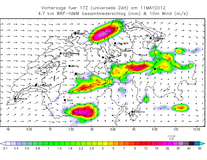
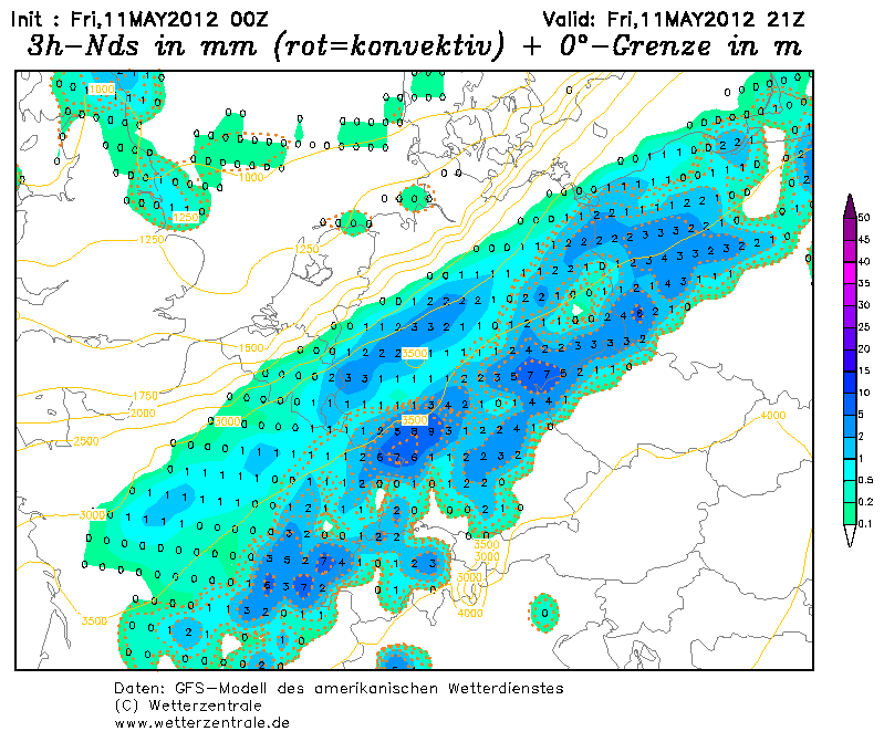
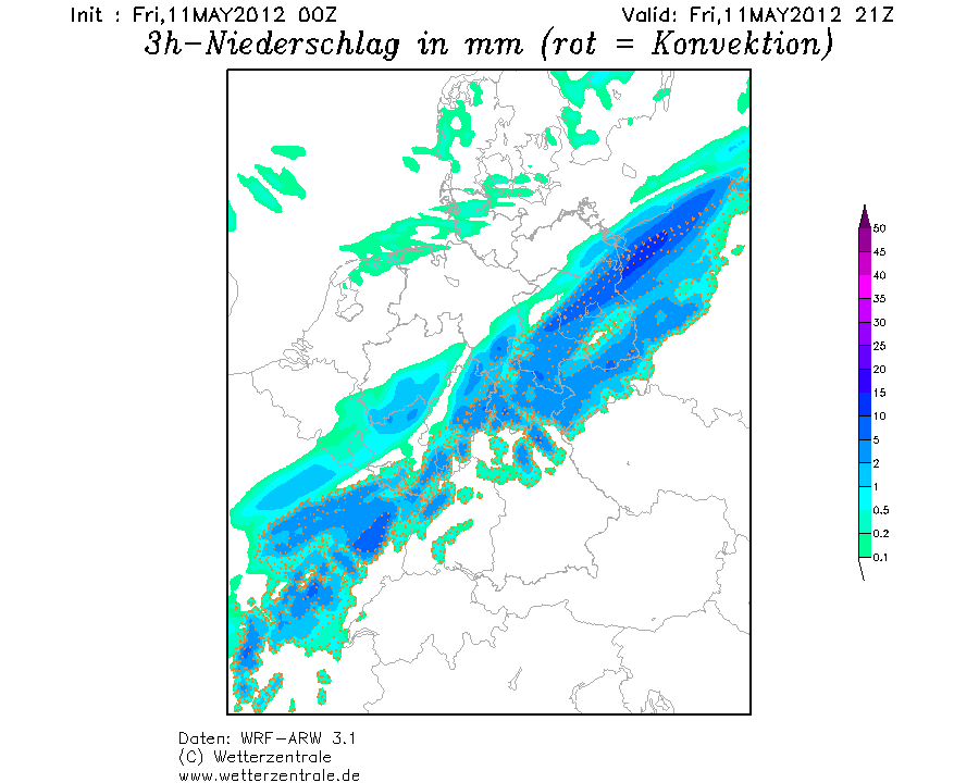
Despite roughly 25 m/s 0-6 km bulk shear and 15-20 m/s shear in the lowest 3 km, main uncertainty regarding organized DMC remains, if storms will be able to root into the warm and moist BL due to the analyzed character of the front itself. Well organized multicells/isolated supercells are likely with this overlap of shear and 500-800 J/kg MLCAPE (with locally peaks in excess of 1 kJ/kg possible). The main hazard will be isolated large hail for elevated storms along the northern part of the level 1 and large hail/strong to severe wind gusts for storms with deviant storm motion, which ride along the surface front to the E/SE. With a rapid increase of LCL height towards the prefrontal air mass (up to 1.5 - 2 km), dry/deeply mixed subcloud layers and modest (in strength) sideward MCS propagation vectors forecast, short line-up of storms with more concentrated swaths of severe winds are possible, mainly over C/E-Germany. The tornado risk is not zero (especially when backing LL wind component due to the prefrontal thermal trough is maximized over C/E-Germany during the afternoon/early evening hours), but ill defined LL lapse rates/CAPE and weak LL helicity keep overall tornado probabilities limited. Finally, with effective PW values well in excess of 30 mm along that front, an heavy to excessive rainfall risk is evident, but also limited due to the forward propagating storm motions. If storm clustering indeed occurs (like a few model outputs in the past showed), heavy/excessive rain will be likely.

Storms also enter NW/N-Poland during the afternoon hours onwards with a large hail/strong to severe wind gust threat due to a more favorable 20 m/s DLS and roughly 800 J/kg MLCAPE overlap. The tornado risk increases over NE Poland and also from Lithuania towards Estonia with SRH-1 in excess of 200 m^2/s^2 and LCLs below 800 m. Coverage of storms becomes questionable with decreasing CAPE, weak cap and modest forcing, supportive for numerous showers/isolated thunderstorms. However, the risk for a few tornado events is present and hence the level 1 was expanded well to the NE.

Between 15-18Z, thunderstorm coverage and intensity also increases over C-France, as thermal gradient along the cold front sharpens but also due to the passage of numerous weak PVA maxima during the afternoon hours onwards....with increasing strength during the night. MLCAPE over C/E-France is in the order of 500-800 J/kg but increases to well in excess of 1000 J/kg over SW-France/far N-Spain, where forcing however will be weaker. Due to the parallel alignement of the boundary to the mean flow, only a small/concentrated area along that front will see an overlap of best shear (25 m/s DLS)/CAPE. Isolated to scattered thunderstorms evolve along that boundary with a fast E/NE ward progression. Large hail and severe wind gusts are likely with any storm and again concentrated swaths of severe wind gusts are possible with any line-up of storms. Highest thunderstorms coverage likely occurs over C/E-France and NW/N Switzerland.

During the night hours, overall thunderstorm activity along the cold front decreases with gradually cooling PBL (weakening thermal gradient). However as the cold front finally approaches the Jura mountains until midnight, thunderstorm activity remains enhanced in that area and we can't exclude the development of a cluster of showers and thunderstorms, which moves from N-Switzerland towards the east, affecting S-Germany and W/NW Austria during the night. Adequate MUCAPE is present during that time frame for a few stronger cells with isolated large hail, but the main activity will be elevated with strong wind gusts and marginal hail, next to heavy rainfall.

No level 2 was added due to numerous restricting effects, mentioned above. However, an upgrade may be performed later on, if any region reveals more distinct signs.
Nach wie vor erstaunlich wie gross der Unterschied im Bezug auf das das Timing bei GFS und WRF ist (Quelle wetterzentrale.de ):
Siehe auch Beitrag von Necronom ( http://www.sturmforum.ch/viewtopic.php? ... 40#p147897) Hier mal für 21Z...

Bild

Bild


Gespannte Grüsse
Crosley
Zuletzt geändert von crosley am Fr 11. Mai 2012, 10:08, insgesamt 1-mal geändert.

Damaro, Bern

Re: Synop: Gewitter, 11./12.05.2012

Beitrag von Damaro, Bern »

Neben Estofex ist die Prognose von Keraunos ebenfalls ein Muss. ;)
Bild
Quelle des Bildes:
http://www.keraunos.org/prevision-orage ... utlook.htm
La zone visée sera exposée à un risque orageux plus marqué. En effet, la constitution attendue sur ces régions de zones de convergence en basses couches devrait parvenir à déclencher plus nettement la convection, au sein de profils rendus très fortement instables par le maintien jusqu'en fin de journée de hautes valeurs de thêta (Θ'w > 18°C à 850 hPa). Une MUCAPE parfois supérieure à 2000 J/kg, avec MULI inférieurs à -6K, est ainsi prévue localement entre le nord de l'Auvergne et la Bourgogne. Malgré cette forte instabilité latente, les déclenchements de convection qui seront observés entre le milieu d'après-midi et la fin de soirée devraient peiner à s'organiser de manière significative, compte tenu de forçages d'altitude insignifiants. Il n'empêche que les orages qui évolueront dans cette zone pourront être localement forts, avec risque de chutes de grêle, de rafales de vent supérieures à 70 km/h et d'intenses précipitations.

Compte tenu de cisaillements profonds parfois supérieurs à 20 m/s et d'une hélicité supérieure à 150 m²/s² sur l'épaisseur 0-3 km, des structures de type supercellulaire, à dominante classique, sont susceptibles de se développer, avec risque lié de formations tourbillonnaires. La faiblesse de l'hélicité en très basses couches (SRH 0-500 m < 50 m²/s²) limitera néanmoins la probabilité d'évolution jusqu'au stade de tornade ; ce risque est donc jugé faible.


Erwartungsvolle Grüsse

221057Gino
Beiträge: 2225
Registriert: Di 1. Jan 2008, 02:49
Geschlecht: männlich
Wohnort: CH 6044 Udligenswil LU
Hat sich bedankt: 2 Mal
Danksagung erhalten: 26 Mal
Kontaktdaten:

Re: Synop: Gewitter, 11./12.05.2012

Beitrag von 221057Gino »


Pät, Basel
Beiträge: 431
Registriert: Di 18. Jun 2002, 09:35
Geschlecht: männlich
Wohnort: 4105 Biel-Benken BL
Hat sich bedankt: 7 Mal
Danksagung erhalten: 69 Mal

Re: NOWCAST: Kaltfront 11./12.05.2012 [Meldungen bis 15 Uhr]

Beitrag von Pät, Basel »

Tinu (Männedorf) hat geschrieben:@Christian
Gute Idee! Bin gespannt wie ein Flitzebogen auf den heutigen Tag. Rein von den Modellen her müsste es eigentlich eher eine Nacht-Show geben (Front kommt eher spät und somit auch eine denkbare Konvergenz). Aber genau das macht mich stutzig. Zum Zeitpunkt 18 UTC (GFS) ist das Menü über dem Mittelland und an den Voralpen eigentlich angrichtet: Wir liegen schön trogvorderseitig, die Indices (Feuchte, Vertikalbewegung, Cape, etc.) stimmen durchwegs. Da braucht es erfahrungsgemäss relativ wenig, unter Umständen sogar "nur" orografische Hebungsprozesse, um in der bereits labilisierten Luftmasse etwas loszutreten.
wie du schön beschrieben hast sind die Zutaten eigentlich vorhanden für eine präfrontale Konvergenzlinie, schon überraschend, dass fast alle Modelle (bis auf NMM) nichts davon wissen wollen. Sickert da doch vorzeitig bodennah kühlere Luft ein? :-?

Die angesprochene Dynamik scheint ja zum Termin 18h (gemäss GFS 00-Lauf) auch bereits einigermassen vorhanden zu sein:
Bild

Ich tippe jetzt mal optimistisch auf eine Auslöse irgendwo am Pruntruter-Zipfel bereits deutlich vor 20h... ;)
Zuletzt geändert von Pät, Basel am Fr 11. Mai 2012, 11:24, insgesamt 1-mal geändert.

Benutzeravatar
pasischuan
Beiträge: 717
Registriert: Mi 1. Dez 2010, 07:03
Geschlecht: männlich
Wohnort: 3608 Thun
Hat sich bedankt: 63 Mal
Danksagung erhalten: 98 Mal

Re: Synop: Gewitter, 11./12.05.2012

Beitrag von pasischuan »

Hallo zämä

ich bin etwas erstaunt .. COSMO-2 hat bis morgen 8 Uhr kein Niederschlag für die Schweiz aufgezeigt... :-?

http://www.landi.ch/meteo/deu/niedersch ... 32451.aspx

Erst ab morgen früh drängt sich langsam NS über die Schweiz ..

GFS (und die Vorhersagen der Wetterdienste) sehen bereits ab 21 Uhr den Niederschlag vor ..
Bild

Ist COSMO-2 die Ausnahme oder ist es tatsächlich immer no so offen (12h vorher) wann genau, oder ob überhaupts heute, der NS kommt?

Gruss Pasi
Zuletzt geändert von pasischuan am Fr 11. Mai 2012, 11:27, insgesamt 2-mal geändert.
Thun, Allmendingen (BE), 580 m.ü.M.


Benutzeravatar
Rontaler
Beiträge: 3271
Registriert: Do 17. Jan 2008, 18:23
Geschlecht: männlich
Wohnort: 6280 Hochdorf LU
Hat sich bedankt: 658 Mal
Danksagung erhalten: 956 Mal

Re: Synop: Gewitter, 11./12.05.2012

Beitrag von Rontaler »

Hmm... Irgendetwas macht mich an dieser ganzen Geschichte stutzig. MeteoCentrale's UKNA Modell macht bis morgen Samstagfrüh 6 Uhr schweizweit so gut wie Null Niederschlag, so auch COSMO und ansatzweise WRF.... GFS 6z ist mittlerweile auch dahingehend umgeschwenkt, dass die (konvektiven) Niederschläge auch frühestens ab Mitternacht vom Juranordfuss und dem Rhein entlang bis nach Schaffhausen weiter in Richtung Süden/Südosten vorankommen.

http://www.meteocentrale.ch/de/wetter/p ... hweiz.html

Ich gehe nach wie vor davon aus, dass der Frontdurchgang recht unspektakulär sein wird, nicht im Sinne einer kompakt voranschreitenden Front, sondern vielmehr nur durch den Windsprung und Neubildung von stratiformen Niederschlägen gezeichnet sein wird. :roll: :-?
Zuletzt geändert von Rontaler am Fr 11. Mai 2012, 13:05, insgesamt 1-mal geändert.
Wetterfanatisch mit Leib und Seele. :)

Benutzeravatar
pasischuan
Beiträge: 717
Registriert: Mi 1. Dez 2010, 07:03
Geschlecht: männlich
Wohnort: 3608 Thun
Hat sich bedankt: 63 Mal
Danksagung erhalten: 98 Mal

Re: Synop: Gewitter, 11./12.05.2012

Beitrag von pasischuan »

Basel scheint ein Treffer zu erhalten heute abend ..

Bild
Quelle: wrf-model.ch

Dagegen wurde nun die Zelle über dem Thunersee ins (Heute morgen gesehen) in Wallis "gezügelt"
Bild
Schade ... :-D
Thun, Allmendingen (BE), 580 m.ü.M.

221057Gino
Beiträge: 2225
Registriert: Di 1. Jan 2008, 02:49
Geschlecht: männlich
Wohnort: CH 6044 Udligenswil LU
Hat sich bedankt: 2 Mal
Danksagung erhalten: 26 Mal
Kontaktdaten:

Re: Synop: Gewitter, 11./12.05.2012

Beitrag von 221057Gino »

hallo zusammen

schweiz ... rothorn ... sounding und cape ... loop
11.05.2012 09:00 UTC - 12.05.2012 15:00 UTC

Bild

Bild

Antworten