Monsun Indischer Subkontinent 2013
Verfasst: Di 25. Jun 2013, 22:48
Hallo
Was ist im Norden Indiens passiert? Habe mich ein bisschen umgesehen. Hier ein Bericht in Dr. Jeff Masters' WunderBlog

Quelle: TRMM seven day rainfall map for Asia
Video auf Sky News mit in den Fluss kollabierenden Häusern: http://news.sky.com/story/1104949/india ... into-river
Link Monsunseiten 2013 des Indischen Wetterdiensts
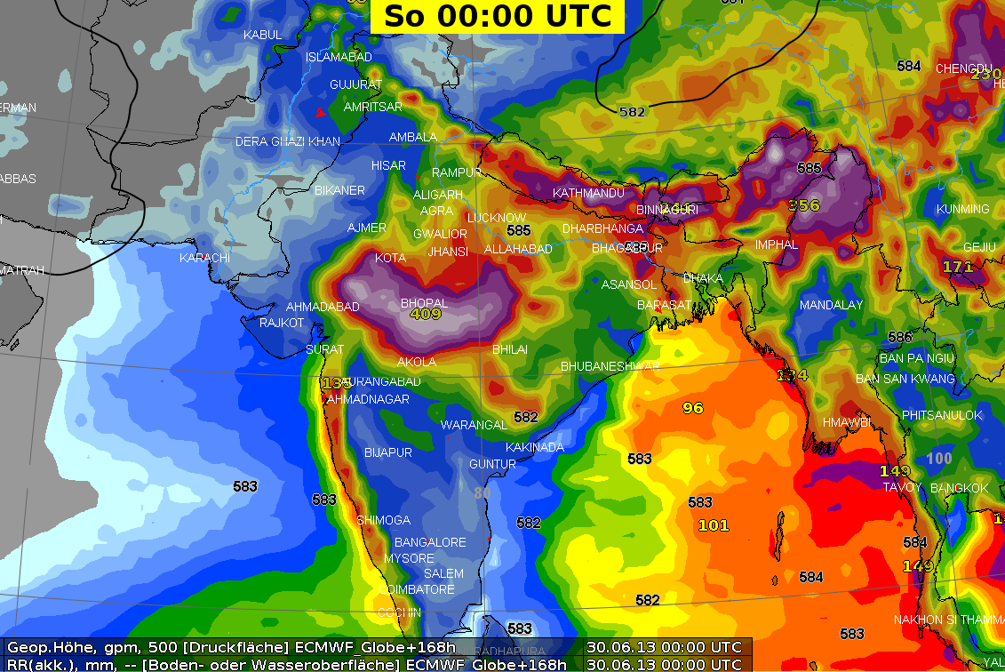
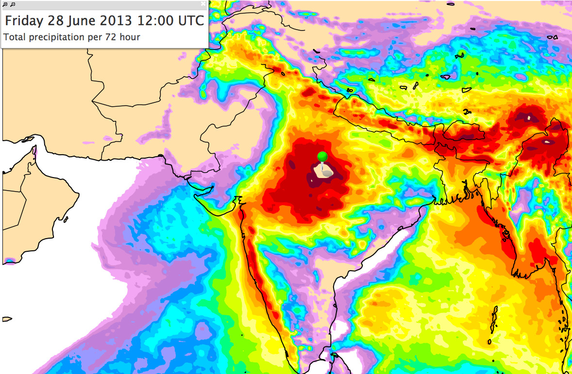
Hier noch die 72 Std. Total Niederschlagsprognose des EZ:
Im Zentrum (Stecknadel) rechnete das Modell Summen >400 mm.
Quelle: ECMWF
Gruss Andreas
Was ist im Norden Indiens passiert? Habe mich ein bisschen umgesehen. Hier ein Bericht in Dr. Jeff Masters' WunderBlog
Quelle: TRMM seven day rainfall map for Asia
Weitere detaillierte Informationen: Dr. Dave Petley's Landslide BlogAccording to the Indian Meteorological Department, Uttarakhand received more than three times (329%) of its normal June rainfall from June 1 - 21, and rainfall was 847% of normal during the week June 13 - 19. Satellite estimates indicate that more than 20" (508 mm) or rain fell in a 7-day period from June 11 - 17 over some regions of Uttarakhand, which lies just to the west of Nepal in the Himalayas. Dehradun, the capital of Uttarakhand, received 14.57" (370 mm) of rain in 24 hours on June 16 - 17. This was the highest 24-hour rainfall in city history, according to an official from the India Meteorological Department. Dr. Dave Petley's Landslide Blog details that the torrential rains triggered a massive landslide that hit Uttarakhand's Hindu shrine in Kedarnath, which lies just a short distance from the snout of two mountain glaciers. The shrine is an important pilgrimage destination this time of year, and was packed with visitors celebrating the char-dham yatra: a pilgrimage to the four holy sites of Gangotri, Kedarnath, Yamnotri and Badrinath. Apparently, heavy rainfall triggered a collapse event on the mountain above Kedarnath, which turned into a debris flow downstream that struck the town. The main temple was heavily damaged, and numerous buildings in the town were demolished. It was Earth's deadliest landslide since the August 2010 Zhouqu landslide in China.
Video auf Sky News mit in den Fluss kollabierenden Häusern: http://news.sky.com/story/1104949/india ... into-river
Quelle: Dr. Jeff Masters' WunderBlogA record early arrival of the monsoon
The June 2013 monsoon rains in Uttarakhand were highly unusual, as the monsoon came to the region two weeks earlier than normal. The monsoon started in South India near the normal June 1 arrival date, but then advanced across India in unusually rapid fashion, arriving in Pakistan along the western border of India on June 16, a full month earlier than normal. This was the fastest progression of the monsoon on record. The previous record for fastest monsoon progression occurred in 1961, when all of India was under monsoon conditions by June 21.
Link Monsunseiten 2013 des Indischen Wetterdiensts
Hier noch die 72 Std. Total Niederschlagsprognose des EZ:
Im Zentrum (Stecknadel) rechnete das Modell Summen >400 mm.
Quelle: ECMWF
Gruss Andreas