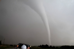
Schönes Hook WNW von Wichita KS:
https://www.sturmforum.ch/forum_uploads ... r_frei.png
Gruss
Bernhard

Werbung
FORECAST/NOWCAST: USA 2009
-
Bernhard Oker
- Moderator
- Beiträge: 6516
- Registriert: Do 16. Aug 2001, 11:02
- Geschlecht: männlich
- Wohnort: 8902 Urdorf
- Hat sich bedankt: 1863 Mal
- Danksagung erhalten: 3111 Mal
Re: NOWCASTING/FORECASTING: USA 2009
Bernhard Oker - Urdorf (ZH/CH) - Meine Webseiten "Never Stop Chasing!"
-
crosley

- Moderator
- Beiträge: 1938
- Registriert: Fr 13. Aug 2004, 15:48
- Geschlecht: männlich
- Wohnort: 5000 Aarau
- Hat sich bedankt: 419 Mal
- Danksagung erhalten: 386 Mal
- Kontaktdaten:
Re: NOWCASTING/FORECASTING: USA 2009
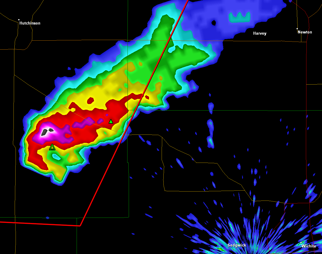
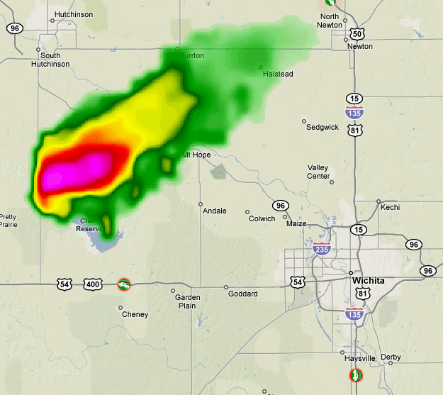
Nordwestlich von Wichita kräftige Zelle. Jetzt vermutlich sogar mit Hook!
Einige Chasers mit Live Cam in der Nähe, aber noch nicht ganz dran:
http://tornadovideos.net/full-screen-chaser-video.php
PS: ist schon eine TV Station "On Air"?
Grüsse Crosley
Edit: Bernhard war schneller!
Einige Chasers mit Live Cam in der Nähe, aber noch nicht ganz dran:
http://tornadovideos.net/full-screen-chaser-video.php
PS: ist schon eine TV Station "On Air"?
Grüsse Crosley
Edit: Bernhard war schneller!
Zuletzt geändert von crosley am Mo 23. Mär 2009, 20:52, insgesamt 1-mal geändert.
-
Severestorms
- Administrator
- Beiträge: 6648
- Registriert: Mo 20. Aug 2001, 17:21
- Geschlecht: männlich
- Wohnort: Zürich
- Hat sich bedankt: 3774 Mal
- Danksagung erhalten: 1660 Mal
- Kontaktdaten:
Re: NOWCASTING/FORECASTING: USA 2009
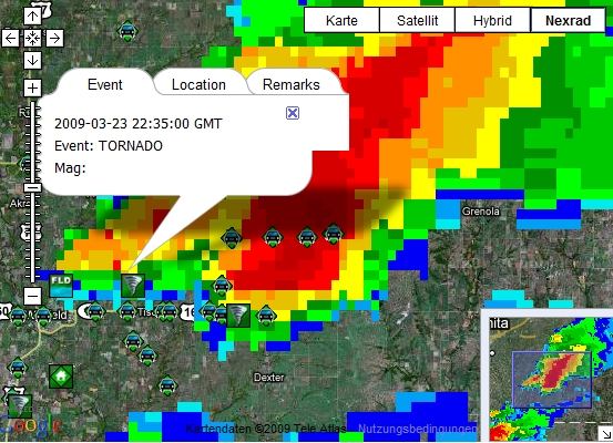
Nun hat es auch in Oklahoma ausgelöst, schön entlang bzw. leicht östlich der Dryline (zu erkennen übrigens an der dünnen hellblauen Reflektivitäts-Linie):
Und die Superzelle, welche vor rund 1 1/2 Stunden die Staatengrenze Oklahoma/Kansas im Bereich der I-35 überquerte und kurz danach ein Hook ausbildete, produzierte auch tatsächlich ein Tornado mit kurzem Touchdown:
Gruss Chrigi
Und die Superzelle, welche vor rund 1 1/2 Stunden die Staatengrenze Oklahoma/Kansas im Bereich der I-35 überquerte und kurz danach ein Hook ausbildete, produzierte auch tatsächlich ein Tornado mit kurzem Touchdown:
Gruss Chrigi
Zuletzt geändert von Severestorms am Di 24. Mär 2009, 00:07, insgesamt 1-mal geändert.
Founder, Owner and Operator of SSWD - Engaged in Science & Research since 1997.
Follow @SturmarchivCH on Twitter to get accurate information about severe, extreme or unusual weather events in Switzerland - fast and reliable.
Follow @SturmarchivCH on Twitter to get accurate information about severe, extreme or unusual weather events in Switzerland - fast and reliable.
-
crosley
- Moderator
- Beiträge: 1938
- Registriert: Fr 13. Aug 2004, 15:48
- Geschlecht: männlich
- Wohnort: 5000 Aarau
- Hat sich bedankt: 419 Mal
- Danksagung erhalten: 386 Mal
- Kontaktdaten:
Re: NOWCASTING/FORECASTING: USA 2009
Wichita wird nun bald von einer Gewitterlinie überrollt.
Mit der Towercam (360° schwenkbar), sind bereits erste Blitze auszumachen.
Link: http://www.360wichita.com/wichitacam/
Grüsse Crosley
Mit der Towercam (360° schwenkbar), sind bereits erste Blitze auszumachen.
Link: http://www.360wichita.com/wichitacam/
Grüsse Crosley
-
221057Gino
- Beiträge: 2225
- Registriert: Di 1. Jan 2008, 02:49
- Geschlecht: männlich
- Wohnort: CH 6044 Udligenswil LU
- Hat sich bedankt: 2 Mal
- Danksagung erhalten: 26 Mal
- Kontaktdaten:
Re: NOWCASTING/FORECASTING: USA 2009
Gutenmorgen
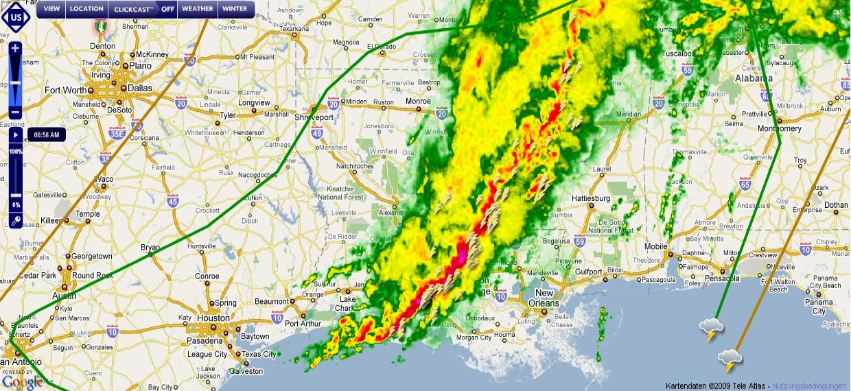
Es geht wieder los in den Southern Plains oder auch Dixie genannt ...
Eine gewaltige Gewitterlinie oder Squallline hat sich gebildet ( Louisiana ) ...
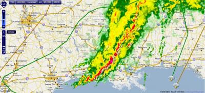
Es geht wieder los in den Southern Plains oder auch Dixie genannt ...
Eine gewaltige Gewitterlinie oder Squallline hat sich gebildet ( Louisiana ) ...

Zuletzt geändert von 221057Gino am Do 26. Mär 2009, 09:20, insgesamt 1-mal geändert.
Meteogram CH - Udligenswil LU
http://forecast.uoa.gr/gmap/image/index ... 2,8.400671
http://gpvjma.ccs.hpcc.jp
https://twitter.com/Gino_Lucerne_CH
https://twitter.com
So long
Gino
http://forecast.uoa.gr/gmap/image/index ... 2,8.400671
http://gpvjma.ccs.hpcc.jp
https://twitter.com/Gino_Lucerne_CH
https://twitter.com
So long
Gino
-
221057Gino
- Beiträge: 2225
- Registriert: Di 1. Jan 2008, 02:49
- Geschlecht: männlich
- Wohnort: CH 6044 Udligenswil LU
- Hat sich bedankt: 2 Mal
- Danksagung erhalten: 26 Mal
- Kontaktdaten:
Re: NOWCASTING/FORECASTING: USA 2009
Hallo zusammen
Severe Storms through Wednesday night ...
Severe storms will move from eastern Texas into Louisiana ... Mississippi and Alabama
later Wednesday night ... These storms can pack damaging winds of greater than 60 mph ...
large hail and a few tornadoes ...
Severe weather can be very dangerous at night ... especially Tornadoes ...
which cannot be seen in the dark and strike when people are sleeping ...
Late-Week Severe Potential ...
The severe storms through Wednesday will just be one of several waves
of severe weather expected across this region ...
A strong upper - level trough will shift into the southern Rockies on Thursday
and severe afternoon storms can fire ahead of the trough from eastern Texas
and southeastern Oklahoma through the lower Mississippi Valley and central Gulf Coast ...
Friday may pose the highest risk of severe weather ... There will be significant turning of winds
in the atmosphere, and much colder air plunging through the Rockies into the Southern Plains
will clash with warm moist air flowing out of the Gulf ...
We expect an outbreak of severe storms including numerous Tornadoes across the Arklatex region ...
A line of strong storms will progress eastward on Friday night
and could threaten the Carolinas ... Georgia and Florida over the weekend ... ( Quelle: AccuWeather )
Meteogram CH - Udligenswil LU
http://forecast.uoa.gr/gmap/image/index ... 2,8.400671
http://gpvjma.ccs.hpcc.jp
https://twitter.com/Gino_Lucerne_CH
https://twitter.com
So long
Gino
http://forecast.uoa.gr/gmap/image/index ... 2,8.400671
http://gpvjma.ccs.hpcc.jp
https://twitter.com/Gino_Lucerne_CH
https://twitter.com
So long
Gino
-
urbi
Re: NOWCASTING/FORECASTING: USA 2009
Spannend
Danke Gino für die Mitteilung
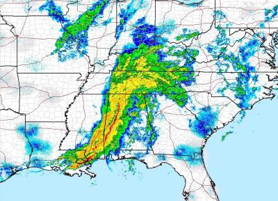
Hier noch eine Animation
Nur Animation

Zum manövrieren
http://www.ssec.wisc.edu/data/paw/usus_ ... _none.html
Grüsse
Urbi
Danke Gino für die Mitteilung
Hier noch eine Animation
Nur Animation
Zum manövrieren
http://www.ssec.wisc.edu/data/paw/usus_ ... _none.html
Grüsse
Urbi
-
221057Gino
- Beiträge: 2225
- Registriert: Di 1. Jan 2008, 02:49
- Geschlecht: männlich
- Wohnort: CH 6044 Udligenswil LU
- Hat sich bedankt: 2 Mal
- Danksagung erhalten: 26 Mal
- Kontaktdaten:
Re: NOWCASTING/FORECASTING: USA 2009
@Urbi ( Salü )
No problem ... auf das ( Severe Weather ) habe ich immer ein Auge drauf ...
Ist mein Lieblingsfach in der hobbyMeteo Küche ... Tornadoes und Hurricanes ...
No problem ... auf das ( Severe Weather ) habe ich immer ein Auge drauf ...
Ist mein Lieblingsfach in der hobbyMeteo Küche ... Tornadoes und Hurricanes ...
Meteogram CH - Udligenswil LU
http://forecast.uoa.gr/gmap/image/index ... 2,8.400671
http://gpvjma.ccs.hpcc.jp
https://twitter.com/Gino_Lucerne_CH
https://twitter.com
So long
Gino
http://forecast.uoa.gr/gmap/image/index ... 2,8.400671
http://gpvjma.ccs.hpcc.jp
https://twitter.com/Gino_Lucerne_CH
https://twitter.com
So long
Gino
-
crosley
- Moderator
- Beiträge: 1938
- Registriert: Fr 13. Aug 2004, 15:48
- Geschlecht: männlich
- Wohnort: 5000 Aarau
- Hat sich bedankt: 419 Mal
- Danksagung erhalten: 386 Mal
- Kontaktdaten:
Re: NOWCASTING/FORECASTING: USA 2009
Bilderbuch "Komma Echo"
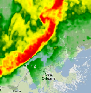
Beschreibung: http://kkd.ou.edu/METR%202603/bow%20ech ... ematic.jpg
Grüsse Crosley
Beschreibung: http://kkd.ou.edu/METR%202603/bow%20ech ... ematic.jpg
Grüsse Crosley
-
urbi
Re: NOWCASTING/FORECASTING: USA 2009
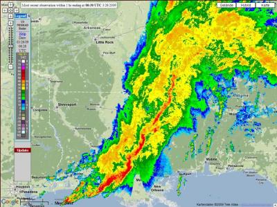
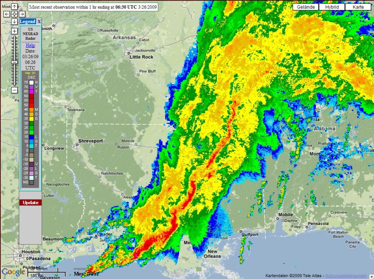
Nochmals ein Radarbild

http://radar.weather.gov/ridge/radar.ph ... 1&loop=yes
Menu: (Mit Java-Animation)
http://www.srh.noaa.gov/ridge/
0908 UTC
@Crosley
Besten Dank für die Komma Info
Grüsse
http://radar.weather.gov/ridge/radar.ph ... 1&loop=yes
Menu: (Mit Java-Animation)
http://www.srh.noaa.gov/ridge/
0908 UTC

@Crosley
Besten Dank für die Komma Info
Grüsse
Zuletzt geändert von urbi am Do 26. Mär 2009, 10:26, insgesamt 4-mal geändert.