Servus,
der heutige Tag startet vielversprechend, im Gegensatz zu gestern befindet sich die dichte Bewölkung über Frankreich gute 200km weiter westlich. Ich rechne ab den Mittagsstunden bzw. dem frühen Nachmittag mit ersten Entwicklungen am Jura. Je nachdem wie stark der Deckel ist, wird es nur einzelne dafür aber umso heftigere Entwicklungen geben oder "relativ" flächig auslösen.
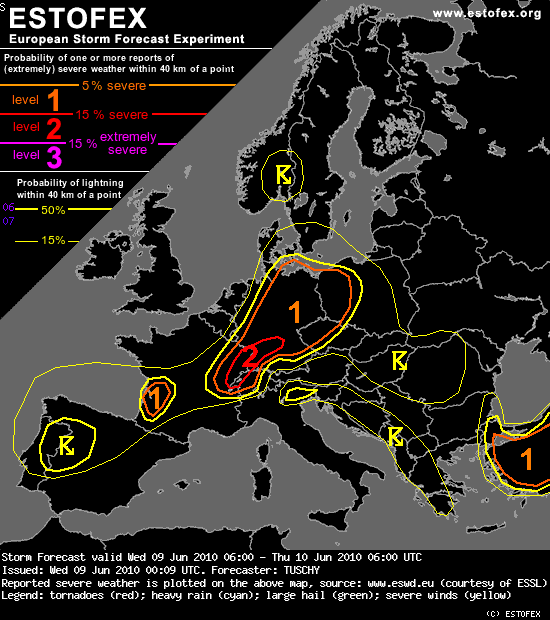
Estofex hat für Jura/Vogesen/Schwarzwald ein Level 2 ausgerufen und warnt hauptsächlich vor (sehr) grossem Hagel (Karte siehe oben...

):
Storm Forecast
Valid: Wed 09 Jun 2010 06:00 to Thu 10 Jun 2010 06:00 UTC
Issued: Wed 09 Jun 2010 00:09
Forecaster: TUSCHY
A level 2 was issued for extreme W-Switzerland, E-France and SW-Germany, mainly for large hail (a significant event is possible) and strong to severe wind gusts.
...
DISCUSSION
... Switzerland, Germany, W- Czech Republic and parts of Poland ...
Seems to be a transition day for this area, as the potent upper trough to the west still intensifies on site with no appreciable eastward progression. Hence, weak ridging at mid-levels persists with numerous waves creeping in from the SW during the forecast. Therefore, initiation occurs over a prolonged period with no significant upper support and hence more sporadic in nature. However, mid-/upper streamline pattern achieves a more diffluent pattern during the night hours, which may assist in enhanced convection. Also, local convergence zones, rough topography like the Black Forest, foehn effects along the northern Alps and regionally moisture pooling along decaying or diffuse surface fronts induce even more uncertanties in respect of where highest thunderstorm coverage may occur. For now, we went with a blend of better forcing, best BL air mass quality and best model agreement.
Yesterday at 22Z, GFS was on track with dewpoint forecasts, but quite unrealistic jumps are forecast tomorrow noon/afternoon. Some daytime mixing and modest moisture advection in mind, we keep surface dewpoints a bit lower than GFS, but agree with EZMWF and foresee roughly 1000 J/kg MLCAPE (with even higher SBCAPE/ICAPE magnitudes) from S-Germany east/northeastwards. In addition, mid-level lapse rates undergo modest steepening during the forecast wich foster widespread CAPE build-up. CIN decreases from south to north, but expected more isolated initiation may not inhibit insolation during the day with full surface mixing expected. The cap will be conquerable and it could keep thunderstorms more discrete for a longer period over S/central-Germay.
DLS increases from east to west (10-20 m/s) with strong anvil layer shear. Main concern right now is quite widespread and strong directional shear over S-Germany and Switzerland. Given favorable shear/CAPE overlap in the level 2 area, good CAPE build-up in the hail growth zone and a well mixed subcloud layer (foehn effects), large hail will be the main risk with significant events possible. Strong to severe downdrafts are also forecast given supportive environment. Initiation will be more isolated at 12Z onwards with more widespread development during the later afternoon hours along the Black Forest. This activity may grow upscale into a cluster of storms, and despite weak to modest shear, cold pool driven thunderstorm line(s) may pose a strong to severe wind gust and hail risk, while affecting central/north Germany thereafter.
An isolated tornado event can't be ruled out but right now there are no real foci for a more concentrated/augmented tornado risk.
Quelle:
http://estofex.org/cgi-bin/polygon/show ... recast.xml
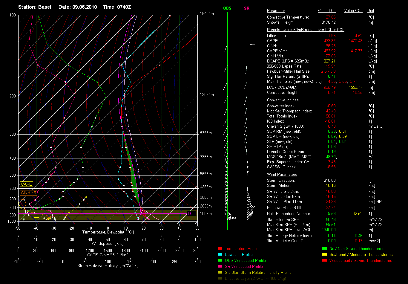
Kräftige Scherung und SRH Werte lassen vor allem anfangs, wenn die Zellen noch isoliert auftreten, eine schnelle Organisation und Superzellen vermuten:

Quelle:
http://lightningwizard.estofex.org/
Später am Nachmittag/Abend sollen laut den Fexen verbreitet mit Gewittern gerechnet werden und unter Umständen ein Cluster/MCS entstehen. Zudem sinken die LCL(Wolkenbasen) im Laufe des Nachmittages sukzessive ab, was zumindest in Theorie Tornados fördern würde.
Die Leute von Keraunos haben für die betroffene Region eine 2/4 ausgegeben und warnen vor organisierten Gewittern und entsprechenden Begleiterscheinungen.
http://www.keraunos.org/prevision-orage ... utlook.htm
Wo und Wie Föhn auftritt und sich auf mögliche Gewitter entlang der (Vor-)Alpen/Mittelland auswirkt entzieht sich meiner Ortskenntnis, es sei aber gesagt das Estofex ein Level 1 für die Westhälfte der Schweiz ausgegeben hat, während es weiter in Richtung Osten laut ihnen immer unwahrscheinlicher wird. Ich denke die eine oder andere Überraschung ist aber auch hier noch drin.
Mich persönlich stimmt der sonnige Start in den Tag sowie die Lokalmodelle (Cosmo, WRF) recht optimistisch.

Gruss Benni
p.s.: @Chrigi, warst ein bisschen schneller, nehme noch Flux das Estofex Kärtle raus und hänge meinen Beitrag hier an.