Allso Estofex ist kein prop.bei mier
gruss sacha

Werbung
NOW: Unwetterphase 3. Tag: 12.07.2010
-
sacha Buochs NW
- Beiträge: 35
- Registriert: Do 23. Jul 2009, 17:23
- Wohnort: Buochs
-
ke51ke

- Beiträge: 469
- Registriert: Di 21. Apr 2009, 18:12
- Geschlecht: männlich
- Wohnort: Uri (Schattdorf)
- Kontaktdaten:
Re: NOW: Unwetterphase 3. Tag: 12.07.2010
Ja estofex geht seit Mittag wieder. Viele andere gehen aber noch nicht.
Wie schätzt ihr die Lage für die Schweizer Alpen ein?
Gruss
Wie schätzt ihr die Lage für die Schweizer Alpen ein?
Gruss
Schattdorfer Hausberg Haldi:
http://www.haldi-uri.ch/
Wetterstation Schattdorf:
www.rolitech.ch/wetter
http://www.haldi-uri.ch/
Wetterstation Schattdorf:
www.rolitech.ch/wetter
-
lukasm
- Beiträge: 703
- Registriert: Fr 3. Jul 2009, 17:52
- Hat sich bedankt: 205 Mal
- Danksagung erhalten: 131 Mal
Re: NOW: Unwetterphase 3. Tag: 12.07.2010
Hallo zusammen
@Yanis: Doch, im Winter war das auch schon so. 08. Januar 2010, oder da, wo in Norddeutschland diese enormen Neuschneemengen fielen. Dort warens natürlich weniger die Blids.de, aber DWD, die Unwetterzentrale und co waren auch total überlastet.
Bei Estofex kommt bei mir auch die halbe Zeit:
Aber damit nicht noch mehr Leute probieren, befriedigen wir mal das Sturmforum
Viele Grüsse
Lukas
@Yanis: Doch, im Winter war das auch schon so. 08. Januar 2010, oder da, wo in Norddeutschland diese enormen Neuschneemengen fielen. Dort warens natürlich weniger die Blids.de, aber DWD, die Unwetterzentrale und co waren auch total überlastet.
Bei Estofex kommt bei mir auch die halbe Zeit:
Anscheinend haben sie jetzt ne Notseite hergestellt, dass nur noch die Frontseite aufgerufen wird --> Weniger Traffic ... Edit: Nun wird stofex gehen. Die Vorhersage wird nicht mehr über das showforecast-Script geladen, sondern ist direkt in einer HTML-DateiNot Found
The requested URL /cgi-bin/polygon/showforecast.cgi was not found on this server.
Apache/1.3.33 Server at estofex.org Port 80
Aber damit nicht noch mehr Leute probieren, befriedigen wir mal das Sturmforum
Storm Forecast
Storm Forecast
Valid: Mon 12 Jul 2010 06:00 to Tue 13 Jul 2010 06:00 UTC
Issued: Sun 11 Jul 2010 23:09
Forecaster: GROENEMEIJER
A level 2 was issued for severe wind gusts, large hail and excessive precipitation, and to a lesser extent for tornadoes across parts of the Benelux, northwestern and northern Germany, and Jutland.
A level 1 was issued for severe wind gusts, large hail, and excessive precipitation surrounding the level 2 area, including SWern Sweden, SE Norway, much of Germany, the western Alps, northern Italy and northern, central and eastern France.
A level 1 was issued for the central and eastern Balkans and western parts of the Ukraine mainly for excessive precipitation.
SYNOPSIS
An intense shortwave trough approaches a warm and moist air-mass over western Europe. Severe weather is expected from the resulting widespread convection. A weak mid-level low over the western Ukraine stays almost stationary.
DISCUSSION
France, Benelux, northwestern Germany...
A frontal zone, marking the gradient of the very warm air over the continent and cooler air to its west stretches roughly from SW France across the Benelux to Denmark and central Sweden. As the approaching trough from the Atlantic ocean approaches, a frontal wave is expected to develop. The associated surface low is expected to travel NNEward across the far southern North Sea during the morning. A helical flow will exist in the warm air advection regime to its northeast over the Benelux. Elevated convection is expected to develop here, and possibly further south across France in places. As the surface low moves northward, the helical flow moves off to the North Sea limiting the chance surface-based storms being able to tap into this flow.
On the approach of the trough, a strong 25-30 m/s jet at 500 hPa is expected to move partly over the warm air, creating an overlap between strong wind shear and MLCAPE. Low-level shear is strong as well with 850 hPa speeds of 15-20 m/s forecast across the Netherlands by the GFS model at 12 UTC. ECMWF and GFS are consistent in increasing convective activity during the morning hours and early afternoon as the frontal zone and the associated convection starts to translate eastward. More of the convection over the Benelux will become surface-based and tap the MLCAPE-rich air east of the front, where 1000-2000 J/kg should be available.
Given the strength of the forcing and the low-level shear, it is likely that some storms become organized as a bow-echo especially in the level 2 area. Besides the widespread severe winds associated with such a system, large hail may also occur with these storms.
North central Germany, Denmark, SWern Sweden, SE Norway...
The forcing for upward vertical motion should translate northeastward during the afternoon or evening when north-central Germany and Denmark will also be affected. It is unclear at this moment whether the convection will mostly develop locally or be in the form of an MCS moving into the area. In either case, wind gusts and heavy rain will be primary threats.
SW Sweden and/or SE Norway may be affected late on Monday or early Tuesday a nocturnal MCS. There will still be a risk of severe wind gusts with that system.
France, Central and Southern Germany, Switzerland ...
As the front moves eastward during the day, storms are expected to form ahead of it, first affecting central France, then eastern France and Switzerland and ultimately Germany. Copious amounts of MLCAPE in the 1000-2000 range should be available and about 15-20 m/s deep-layer shear should be present. The strongest storms will likely produce large hail and severe wind gusts.
Northern Italy...
Wind shear and forcing will be less across this region, but large amounts of MLCAPE, possibly in excess of 2000 J/kg, should allow scattered storms in this region to produce large hail.
Western Ukraine, central and eastern Balkans...
In vicinity of the broad upper-level low diurnally-induced slow-moving storms are expected yet again. These may locally produce high precipitation amounts, in part because of their slow translational speed. Some landspouts (weak tornadoes) will also be possible in these areas with weak winds, low LCL heights and strong solar heating.

So, und jetzt bitte nicht mehr auf Estofex zugreifenForecast Update
Forecast Update
Valid: Mon 12 Jul 2010 08:00 to Tue 13 Jul 2010 06:00 UTC
Issued: Sun 11 Jul 2010 23:09
Forecaster: GROENEMEIJER
A level 3 for severe wind gusts, tornadoes, large hail and excessive precipitation was issued for eastern Netherlands, northwestern and northern Germany, and southwestern Denmark.
A level 2 was issued for an area surrounding the level 2 area fro the same weather phenomena.
A level 1 was issued for severe wind gusts, large hail, and excessive precipitation surrounding the level 2 area, including SWern Sweden, SE Norway, much of Germany, the western Alps, northern Italy and northern, central and eastern France.
A level 1 was issued for the central and eastern Balkans and western parts of the Ukraine mainly for excessive precipitation.
SYNOPSIS
Please refer to the original Storm Forecast for a general discussion of the weather pattern.
DISCUSSION
Benelux, northwestern and northern Germany, western Denmark...
A strong bowing MCS has formed over central France overnight.This system is expected to move quickly NNEward. As the boundary layer warms ahead of this system, the chances of strong and extreme wind gusts will increase. Per 00 and 06 UTC soundings about 1500-2500 J/kg MLCAPE should become available i this air-mass.
Moreover, a few elevated supercells have formed over the Benelux. As forcing by the upper trough increases, coverage of these storms will also increase. With strong helicity being in place and LCL heights being low, storms that become surface-based will have a risk of tornadoes, that may be strong. The threat will be highest roughly in a 100 km broad zone to the northwest of a line from Maastricht to Dortmund to Kiel, where surface winds are from the ENE and boundary layer temperatures moderate.
Both for the disctinct risk of extreme wind gusts with the bow echo, and for the risk of tornadoes an upgrade to level 3 was decided. Moreover, extreme precipitation and large hail will be possible.
It is expected that the bow echo will move into Denmark during the second half of the afternoon and during the evening. Probably the threat of extreme wind gusts will persist at least until the mid-evening, when the system moves into an area of less instability.

Viele Grüsse
Lukas
Zuletzt geändert von lukasm am Mo 12. Jul 2010, 13:22, insgesamt 1-mal geändert.
Der Donner erschüttert die heitere Bläue des Himmels,
Weil hochfliegende Wolken im Äther einander sich stoßen,
Wenn in der Mitte sie stehn von entgegengerichteten Winden.
aus "De rerum natura", 1. Jh. v. Chr. (Titus Lucretius Carus, Lukrez)
Weil hochfliegende Wolken im Äther einander sich stoßen,
Wenn in der Mitte sie stehn von entgegengerichteten Winden.
aus "De rerum natura", 1. Jh. v. Chr. (Titus Lucretius Carus, Lukrez)
-
nordspot
- Beiträge: 2329
- Registriert: So 18. Mär 2007, 16:32
- Geschlecht: männlich
- Wohnort: D-78464 Konstanz
- Hat sich bedankt: 835 Mal
- Danksagung erhalten: 297 Mal
- Kontaktdaten:
Re: NOW: Unwetterphase 3. Tag: 12.07.2010
hoppla, es geht präfrontal los im Südjura und Vogesen. Na dann ist der Schwarzwald auch bald dran.
Gespannte Grüsse
Ralph
@ ke51ke: Flächendeckend, nur genau wann ist noch unsicher..
Gespannte Grüsse
Ralph
@ ke51ke: Flächendeckend, nur genau wann ist noch unsicher..
Zuletzt geändert von nordspot am Mo 12. Jul 2010, 12:57, insgesamt 1-mal geändert.
nordspot Konstanz
-
Mainline
- Beiträge: 97
- Registriert: Do 14. Jun 2007, 21:45
- Geschlecht: männlich
- Wohnort: 5632 Buttwil (640müm)
- Danksagung erhalten: 17 Mal
Re: NOW: Unwetterphase 3. Tag: 12.07.2010
Auch der DWD spricht von Tornados, achja die Seiten gehen übrigens wieder (bei mir aufjedenfall)
:D
-
Thies (Wiesental)
- Beiträge: 1818
- Registriert: Fr 17. Aug 2001, 07:29
- Wohnort: 79688 Hausen im Wiesental (D)
- Hat sich bedankt: 148 Mal
- Danksagung erhalten: 95 Mal
Re: NOW: Unwetterphase 3. Tag: 12.07.2010
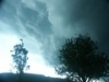
Es quillt mächtig über den Vogesen. Das sind wunderbare Strukturen, bei denen sich gem. aktuellem Status 2 grössere Zellen entwickeln könnten. Es bleibt jedoch abzuwarten, wie gut sich die Zellen aus den Vogesen lösen können. Gem. Sat-Bild handelt es sich um den verlängerten Arm der Westdeutschen Gewitterlinie.
Gruss, Thies
Update: Egal ob die Zellen in den Rheingraben ziehen oder nicht... das sind Prachtexemplare, insb. aufgrund des tiefblauem Himmels, von dem sie (noch) umgeben sind...
Gruss, Thies
Update: Egal ob die Zellen in den Rheingraben ziehen oder nicht... das sind Prachtexemplare, insb. aufgrund des tiefblauem Himmels, von dem sie (noch) umgeben sind...
Zuletzt geändert von Thies (Wiesental) am Mo 12. Jul 2010, 13:23, insgesamt 1-mal geändert.
Thies Stillahn (Gewitterjagd im Dreiländereck D/CH/F)
-
Ben (BaWü)

- Beiträge: 858
- Registriert: Di 28. Jun 2005, 19:35
- Wohnort: Baden Württemberg
- Danksagung erhalten: 59 Mal
- Kontaktdaten:
Re: NOW: Unwetterphase 3. Tag: 12.07.2010
@ Thies: Das sollte ja die präfrontale Konvergenz sein, die man auf manchen Karten eingezeichnet sieht. Ich geh mal davon aus, dass die einiges auslösen wird. Auch Schwarzwald und Jura sollten da was produzieren.
In der Tat jetzt erste kräftige Zelle in den Vogesen. Auch am Jura machts vor sich hin.
Greez
Ben
In der Tat jetzt erste kräftige Zelle in den Vogesen. Auch am Jura machts vor sich hin.
Greez
Ben
Zuletzt geändert von Ben (BaWü) am Mo 12. Jul 2010, 13:32, insgesamt 1-mal geändert.
http://sturmjagd.wordpress.com/
Wetterfotografie in Süddeutschland
Wetterfotografie in Süddeutschland
-
Marco (Hemishofen)

- Beiträge: 1364
- Registriert: So 23. Jun 2002, 18:15
- Geschlecht: männlich
- Wohnort: 8261 Hemishofen
- Hat sich bedankt: 250 Mal
- Danksagung erhalten: 546 Mal
Re: NOW: Unwetterphase 3. Tag: 12.07.2010
Nur Geduld, Leute, das ist schon OK wenn's bei uns nicht schon zu früh abgeht ... schön Labilität aufbauen und dann in einem grossen Knall abbauen 
Rush-hour bei den Wetterdiensten angesagt, hier die oben schon angedeutete Warnkarte der Kollegen in Offenbach:
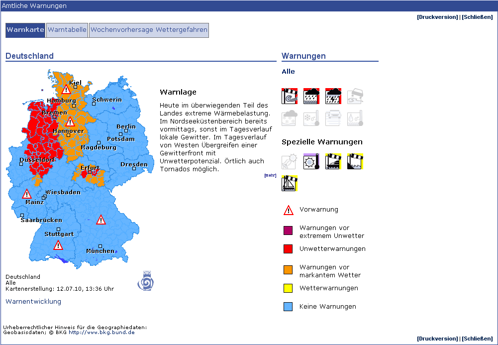
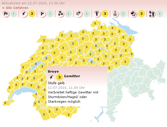
Und auch die Dienstkollegen in Zürich und Genf wagen sich wieder an die allseits so geliebte "Heftige Gewitter möglich" Warnung
(achtung, im Wallis ist Stufe 3 Waldbrand, NICHT Gewitter):
Nächster wichtiger Termin: Payerne 12 UTC ... vielleicht sind Michi oder Andi im Dienst und können uns die "sneak preview" schon vor 12UTC
(Ballon fliegt los und wir können in den Zentralen laufend schon die Daten mitverfolgen während Flug) zum Essen servieren *bittebittebitte*?
Rush-hour bei den Wetterdiensten angesagt, hier die oben schon angedeutete Warnkarte der Kollegen in Offenbach:
Und auch die Dienstkollegen in Zürich und Genf wagen sich wieder an die allseits so geliebte "Heftige Gewitter möglich" Warnung
(achtung, im Wallis ist Stufe 3 Waldbrand, NICHT Gewitter):
Nächster wichtiger Termin: Payerne 12 UTC ... vielleicht sind Michi oder Andi im Dienst und können uns die "sneak preview" schon vor 12UTC
(Ballon fliegt los und wir können in den Zentralen laufend schon die Daten mitverfolgen während Flug) zum Essen servieren *bittebittebitte*?
Zuletzt geändert von Marco (Hemishofen) am Mo 12. Jul 2010, 13:50, insgesamt 1-mal geändert.
Gruss Marco
-------_/)----
-------_/)----
-
Marco (Hemishofen)
- Beiträge: 1364
- Registriert: So 23. Jun 2002, 18:15
- Geschlecht: männlich
- Wohnort: 8261 Hemishofen
- Hat sich bedankt: 250 Mal
- Danksagung erhalten: 546 Mal
Re: NOW: Unwetterphase 3. Tag: 12.07.2010
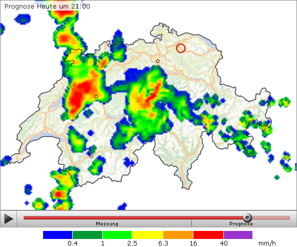
Boaaah, sorry ich muss noch ein posting loswerden - je länger je mehr eine Top-Lage für die W-NW Landesteile!
Neuster CO-2 Lauf explodiert erneut für den Streifen westl. Alpen/Jura, Seeland, zentr. Mittelland, Juranordfuss,
dann auch zentraler Alpennordhang saftige Entwicklungen prognostiziert, hier im NO etwas abgeschwemmt und
nicht mehr ganz so viel Potential ... hier nur ein kleiner screenshot aus einem fantastischen Modelllauf:
Mein Standort 15-21UTC Region Schaffhausen (sh*** zum Znacht abgemacht, Mama's Geburtstag = chasing mit inhibition )
Neuster CO-2 Lauf explodiert erneut für den Streifen westl. Alpen/Jura, Seeland, zentr. Mittelland, Juranordfuss,
dann auch zentraler Alpennordhang saftige Entwicklungen prognostiziert, hier im NO etwas abgeschwemmt und
nicht mehr ganz so viel Potential ... hier nur ein kleiner screenshot aus einem fantastischen Modelllauf:
Mein Standort 15-21UTC Region Schaffhausen (sh*** zum Znacht abgemacht, Mama's Geburtstag = chasing mit inhibition
Gruss Marco
-------_/)----
-------_/)----
-
Bernhard Oker

- Moderator
- Beiträge: 6515
- Registriert: Do 16. Aug 2001, 11:02
- Geschlecht: männlich
- Wohnort: 8902 Urdorf
- Hat sich bedankt: 1863 Mal
- Danksagung erhalten: 3105 Mal
Re: NOW: Unwetterphase 3. Tag: 12.07.2010
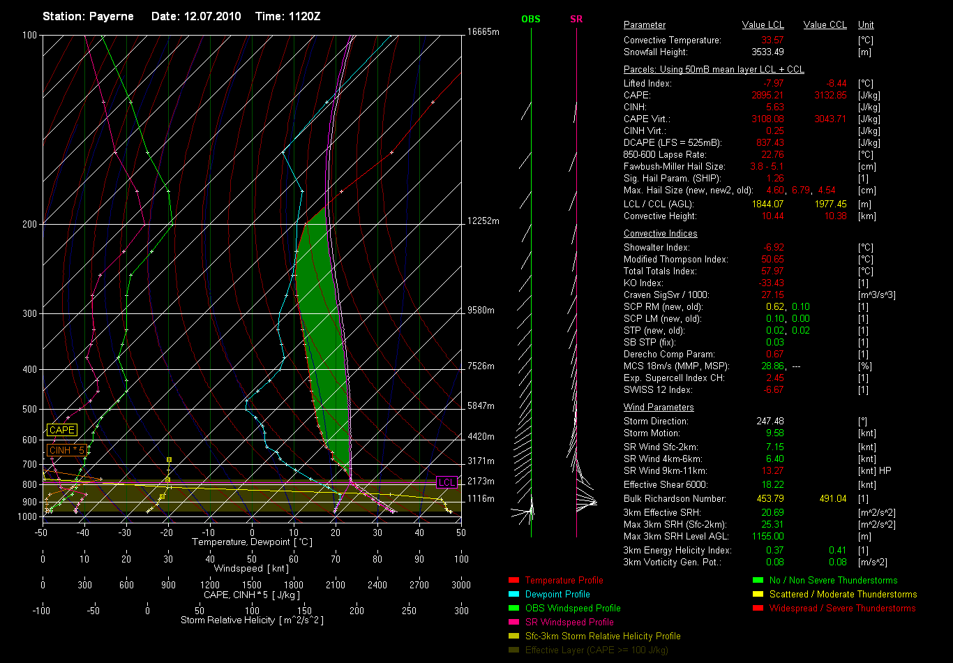
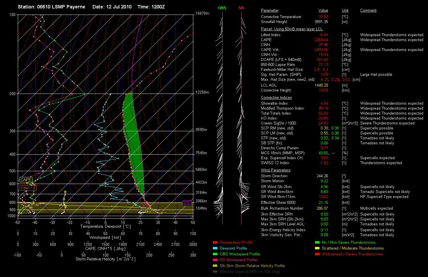
Pseudo Sondierung Payerne 13:20 Uhr mit massivem CAPE und praktisch ungedeckelt. 
Real auch über 2000 J/kg an CAPE:
Sounding Payerne 11Z
Gruss
Bernhard
Real auch über 2000 J/kg an CAPE:
Sounding Payerne 11Z
Gruss
Bernhard
Zuletzt geändert von Bernhard Oker am Mo 12. Jul 2010, 14:05, insgesamt 2-mal geändert.
Bernhard Oker - Urdorf (ZH/CH) - Meine Webseiten "Never Stop Chasing!"