Werbung

Super-Typhoon Bopha

Alles zu (Un)wetter, übriges Europa und weltweit
Antworten
Benutzeravatar
Alfred
Beiträge: 10469
Registriert: Mo 21. Jul 2003, 16:23
Geschlecht: männlich
Wohnort: 8037 Zürich
Hat sich bedankt: 49 Mal
Danksagung erhalten: 90 Mal

Re: Hurricanes 2012 (u.a. Nadine Azoren)

Beitrag von Alfred »

Sali zäme

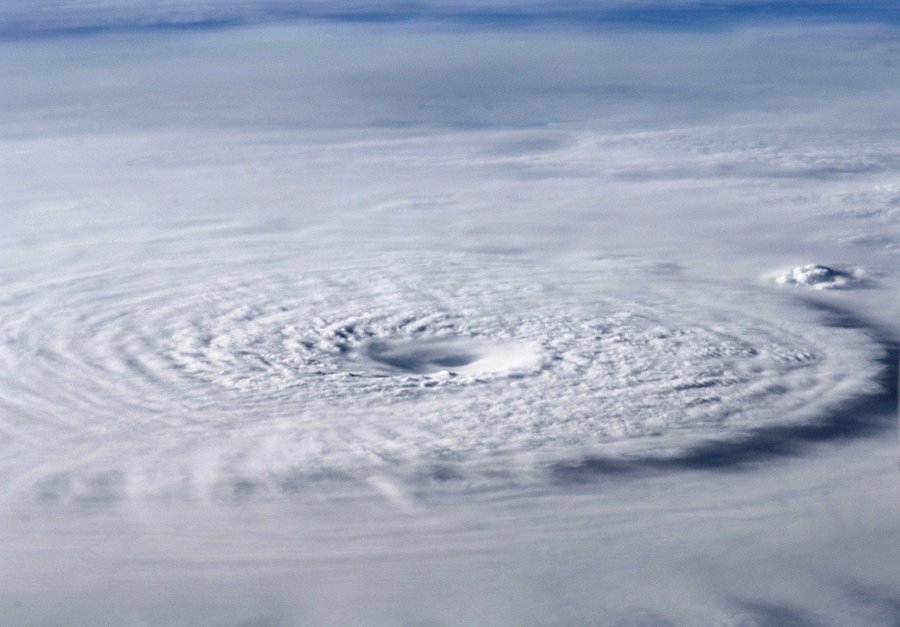
Noch Tropischer Sturm BOPHA (26W / 29W?), auf dessem Weg zu den Philippinen, einige
Koralleninseln liegen.

Bild

Alfred
Zuletzt geändert von Alfred am Mi 28. Nov 2012, 16:20, insgesamt 1-mal geändert.

Severestorms
Administrator
Beiträge: 6648
Registriert: Mo 20. Aug 2001, 17:21
Geschlecht: männlich
Wohnort: Zürich
Hat sich bedankt: 3765 Mal
Danksagung erhalten: 1660 Mal
Kontaktdaten:

Re: Hurricanes & Typhoons 2012 (u.a. HRC Nadine Azoren)

Beitrag von Severestorms »

Bopha organisiert sich, ist mittlerweile ein Typhoon und steuert genau auf die Philippinen zu (könnte dort am Dienstag ankommen).

Bild
Quelle: http://www.usno.navy.mil/NOOC/nmfc-ph/R ... wp2612.gif

Zwei Satellitenbild-Animationen:
http://www.ssd.noaa.gov/PS/TROP/floater ... imated.gif
http://icons-ecast.wunderground.com/dat ... t_anim.gif

Täglicher Spezial-Videoblog zu Bopha von David Michael V. Padua (aka Mr. Typhoon), Senior Typhoon Specialist of Meteomedia Philippines:
http://weather.com.ph/weathertv

PS: Was ist der geheime Spruch, damit man die Videos ansehen kann? :?: :?: :?:

Weitere gute Links wie immer auf http://www.typhoon2000.ph/

Gruss, Chris
Founder, Owner and Operator of SSWD - Engaged in Science & Research since 1997.
Follow @SturmarchivCH on Twitter to get accurate information about severe, extreme or unusual weather events in Switzerland - fast and reliable.


Severestorms
Administrator
Beiträge: 6648
Registriert: Mo 20. Aug 2001, 17:21
Geschlecht: männlich
Wohnort: Zürich
Hat sich bedankt: 3765 Mal
Danksagung erhalten: 1660 Mal
Kontaktdaten:

Re: Hurricanes & Typhoons 2012 (u.a. HRC Nadine Azoren)

Beitrag von Severestorms »

Typhoon Bopha (Pablo) hat sich noch einmal verstärkt und trifft in den kommenden 12 Stunden auf Mindanao (Philippinen)! :shock: Das sieht nicht gut aus! :neinei:

Bild
Quelle: http://www.typhoon2000.ph/t2kgraphsat.gif

Bild
Quelle: http://tropic.ssec.wisc.edu/real-time/i ... s&prod=irn

Wie folgt die aktuellste Einschätzung von typhoon2000.ph (http://www.typhoon2000.ph/update.html):
TYPHOON BOPHA (PABLO) UPDATE NUMBER 023
Issued: 7:00 PM PhT (11:00 GMT) Monday 03 Dec 2012
Next Update: 1:00 AM PhT (17:00 GMT) Tuesday 04 Dec 2012
--------------------------------------------------------------------------------

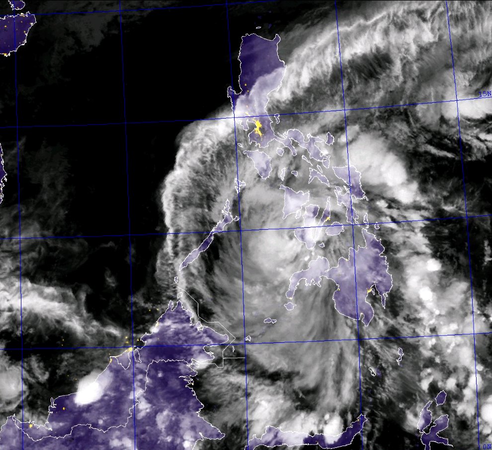
Typhoon Bopha (Pablo) regained strength as it moves closer to Davao Oriental and Surigao Del Sur...continues to endanger Caraga Region. The possible landfall area is between Bislig and Hinatuan Area by tomorrow morning.

Important Note: Typhoon Bopha (Pablo) is almost three times the strength of Tropical Storm Washi (Sendong) which crossed North-Central Mindanao on December 16, 2011. Please take all precautionary measures on this dangerous cyclone. Refer to your national disaster agencies for more details.

Residents and visitors along Mindanao and Visayas should closely monitor the development of Bopha (Pablo).


Do not use this for life or death decision. This update is intended for additional information purposes only. Kindly refer to your national weather agency for official warnings, advisories or bulletins.


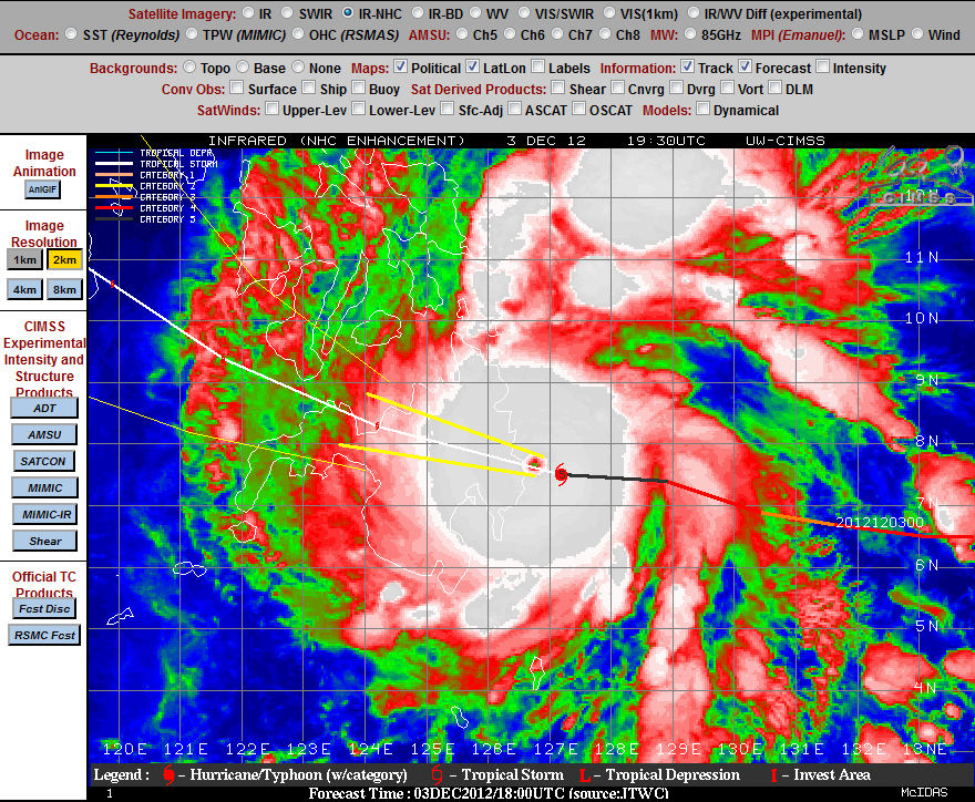
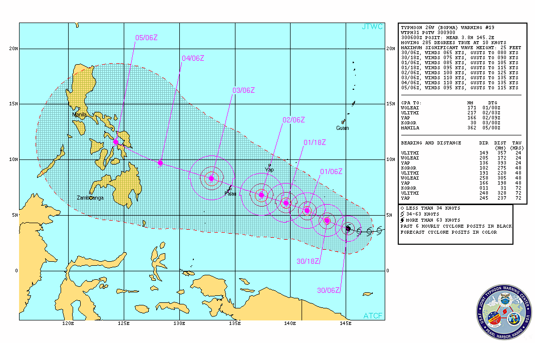
CURRENT STORM ANALYSIS

As of 6 pm today, the eye of Typhoon Bopha was located over the Philippine Sea...about 356 km east-southeast of Bislig City, Surigao Del Sur or 420 km east-northeast of Metro Davao...currently moving west-northwest with a forward speed of 26 km/hr in the general direction of Davao Oriental-Surigao Del Sur Area.

Maximum Sustained Winds (1-min. avg) have increased to 220 km/hr near the center with higher gusts. Typhoon Force Winds (118 km/hr or more) extend outward up to 55 kilometers from the center...and Tropical Storm Force Winds (62-117 km/hr) extend outward up to 185 kilometers. Bopha remains a large-sized tropical cyclone with a diameter of 775 kilometers across. The 24-hour rainfall accumulation near the center of Typhoon Bopha is estimated to be extreme (400 mm).


3-DAY FORECAST OUTLOOK*

Typhoon Bopha is expected to continue moving west-northwest for the next 24 to 36 hours with a slight decrease in its forward speed. After 36 hours, its track will turn to the northwest...and this motion will continue throughout the forecast period. On the forecast track, the core of Bopha is expected to make landfall in between Bislig and Hinatuan on Tuesday morning (approx. 6-7 am Manila Time)...and cross Surigao Del Sur, Agusan Del Sur and Misamis Oriental Tuesday morning until the afternoon, passing more or less 50 km north of Cagayan De Oro City between 4-5pm. By Tuesday evening, Bopha should emerge over the Bohol Sea and then traverse Southern Negros passing very close to Dumaguete City between 11 pm to 12 midnight. The typhoon will traverse Sulu Sea Wednesday morning...passing close to Cuyo and Pamalican Islands late Wednesday afternoon...and over or very close to El Nido, Palawan by late Wednesday evening.

Bopha will still slightly gain strength prior in making landfall and could regain Super Typhoon status tonight. It will then weaken throughout the forecast period due to its passage across the landmass of Mindanao and the Visayas.

The following is the summary of the 3-day forecast outlook on this system:

TUESDAY EVENING: Over Bohol Sea as it weakens to Category 3...about 80 km northwest of Cagayan De Oro [6PM DEC 04: 8.9N 124.0E @ 195kph].
WEDNESDAY EVENING: Over the shores of Northern Palawan as it weakens to Category 2...about 49 km southeast of El Nido, Northern Palawan [6PM DEC 05: 11.1N 120.1E @ 175kph].
THURSDAY EVENING: Maintains its strength as it moves slowly northwestward across the West Philippine Sea...about 248 km west-northwest of Coron, Northern Palawan [6PM DEC 06: 12.6N 118.0E @ 160kph].

*Please be reminded that the Forecast Outlook changes every 6 hours, and the Day 3 Forecast Track have an average error of 250 km...while the wind speed forecast error, averages 35 kph per day. Therefore, a turn to the left or right of its future track and changes in its wind speed must be anticipated from time to time.


EFFECTS & HAZARDS SUMMARY

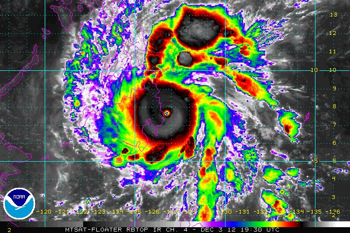
Below is the summary of the storm's parts and its hazards affecting specific areas. You can also view this image link for you to understand the parts.

RAGGED EYE - over water (Philippine Sea) Possible calm and lull conditions (with <20 kph winds) will be expected inside the eye (click here to know more about the EYE).
EYEWALL - over water (Philippine Sea)...not yet affecting any land areas....but the western part of the eyewall will reach the coast of Surigao Del Sur before sunrise Tuesday. Typhoon Conditions with Typhoon Force Winds (>118 kph) will be expected within this wall (click here to know more about the Eyewall).
INNER RAINBANDS - over water (Philippine Sea)...not affecting any land areas...but will reach Caraga Region and Davao Oriental tonight. Tropical Storm Conditions with Tropical Storm Force Winds (62-117 kph) will be expected along these bands.
OUTER RAINBANDS - affecting and spreading across Caraga Region and Davao Oriental. Tropical Depression Conditions with moderate to strong winds (<62 kph) will be expected along these bands (click here to know more about Rainbands).
24HR TOTAL RAINFALL ACCUMULATION - from 5 up to 200 mm (slight to heavy rainfall) can be expected along areas affected by the outer & inner rainbands (see above)...with isolated amounts of 201 to 400 mm (heavy to extreme) along areas near the center of Bopha.
COASTAL STORM SURGE FLOODING - possible 13-18 ft (4-5.5 m) above normal tide levels...accompanied by large and dangerous battering waves can be expected along the coastal, inland lakes and beach front areas of Caraga Region and Davao Oriental beginning tonight. Extreme damage is likely on this type of storm surge. Danger from Rip Currents or Rip Tides can be expected along the rest of the beach-front areas of Western Micronesia, Rest of Mindanao and the Visayas (click here to know more about Storm Surge).
Quelle: http://www.typhoon2000.ph/update.html


Special Coverage: http://weather.com.ph/weathertv

Satellite Loop: http://www.goes.noaa.gov/sohemi/sohemiloops/shphil.html

Und ein Chaser ist offenbar auch vor Ort: CNN Typhoon Correspondent James Reynolds twittert aus dem Sturm => http://twitter.com/#!/typhoonfury

Gruss, Chris
Zuletzt geändert von Severestorms am Mo 3. Dez 2012, 13:52, insgesamt 2-mal geändert.
Founder, Owner and Operator of SSWD - Engaged in Science & Research since 1997.
Follow @SturmarchivCH on Twitter to get accurate information about severe, extreme or unusual weather events in Switzerland - fast and reliable.

Benutzeravatar
Kaiko (Döttingen)
Moderator
Beiträge: 2656
Registriert: Sa 1. Sep 2001, 16:23
Geschlecht: männlich
Wohnort: 5312 Döttingen
Hat sich bedankt: 2063 Mal
Danksagung erhalten: 2111 Mal
Kontaktdaten:

Re: Hurricanes & Typhoons 2012 (u.a. HRC Nadine Azoren)

Beitrag von Kaiko (Döttingen) »

Bild
http://tropic.ssec.wisc.edu/real-time/s ... 000&loop=0

Bild

Landfall steht kurz bevor

Gruss Kaiko
Mitbetreiber des Sturmarchivs Schweiz und Wetterforscher aus Leidenschaft: http://www.sturmarchiv.ch/

Benutzeravatar
Joachim
Beiträge: 2791
Registriert: Do 16. Aug 2001, 10:53
Geschlecht: männlich
Wohnort: 8330 Pfäffikon/ZH
Hat sich bedankt: 54 Mal
Danksagung erhalten: 612 Mal
Kontaktdaten:

Super-Typhoon Bopha

Beitrag von Joachim »

Guete Morge

Während bei uns das Wetter jetzt winterlich geworden ist ... zieht aktuell ein Supertaifun über die Philippinen (Südinsel Mindanao):

Bild

Die Crew der ISS hat von diesem "Monster" ein eindrucksvolles Bild gemacht.
Bild

Und unsere Kollegen von Meteomedia-Manila haben alle Informationen.
http://weather.com.ph/announcements/sup ... umber-024a

Grüsslis

Joachim

Urbi

Re: Super-Typhoon Bopha

Beitrag von Urbi »

Zitat:

04.12.2012 | 09:55 | (DiePresse.com)

Taifun "Bopha" ist der bisher stärkste Taifun der Saison. Bewohner der Ostküste von Mindanao mussten sich in Schutzräumen in Sicherheit bringen.

Der schwere Taifun "Bopha" hat Dienstagfrüh (Ortszeit) die Insel Mindanao im Süden der Philippinen erreicht. Bisher gibt es sechs bestätigte Todesfälle, Zehntausende Menschen sind auf der Flucht. Mit Windgeschwindigkeiten von bis zu 210 Kilometern pro Stunde und starken Regenfällen sei das Unwetter im Osten der Insel auf Land getroffen, teilte die Wetterbehörde des Landes mit. Über 41.000 Menschen seien in rund tausend Notunterkünfte geflüchtet, sagte der Chef der Zivilschutzbehörde, Benito Ramos.

Unter den Todesopfern sei eine ältere Frau, die von einem auf ihr Haus gestürzten Baum erschlagen wurde. Zudem würden vier Fischer vermisst, sagte ein Regierungsvertreter. Drei Menschen seien von umstürzenden Bäumen getroffen worden, zudem habe ein Mensch einen Herzinfarkt erlitten, sagte Ramos. Der Zustand der Opfer sei aber noch unklar. Der Zivilschutzchef führte die bisher niedrige Opferzahl auf die umfassenden Evakuierungen zurück. Anwohner der Küstenregionen und niedrig gelegener Siedlungen seien wegen der Gefahr von Überschwemmungen und Erdrutschen in Sicherheit gebracht worden.
Ausnahmezustand

Auf Mindanao herrschte am Dienstag Ausnahmezustand: Flug- und Fährverbindungen wurden annulliert, die Schulen blieben geschlossen. In der Stadt Cagayan de Oro mit ihren rund 600.000 Einwohnern traten am Dienstag mehrere Flüsse über die Ufer und verursachten Überschwemmungen. Um Brände und tödliche Elektroschläge zu vermeiden, waren am Morgen weite Teile der Insel ohne Strom. Bewohner Mindanaos berichteten von entwurzelten Bäumen und vom Sturm abgedeckten Dächern.

Der Taifun zog leicht nachlassend Richtung Nordwesten weiter. Er wurde im weiteren Tagesverlauf im Süden der Insel Negros erwartet, wo mit schweren Regenfällen gerechnet wurde. "Bopha" ist bereits der 16. schwere Sturm, der in diesem Jahr auf die Inselgruppe im Westen des Pazifiks trifft.

Im Schnitt durchleben die Anwohner der Philippinen etwa 20 schwere Stürme pro Jahr. Im August wurden in dem südostasiatischen Land bei mehreren Unwettern rund 100 Menschen getötet.


_____________________________

11:30 UTC

Bild
+   nrlmry.navy.mil NexSat


Bild
+  webgms.iis.u-tokyo.ac.jp


_____________________________


Gruss Urbi
Zuletzt geändert von Urbi am Di 4. Dez 2012, 14:55, insgesamt 2-mal geändert.

Severestorms
Administrator
Beiträge: 6648
Registriert: Mo 20. Aug 2001, 17:21
Geschlecht: männlich
Wohnort: Zürich
Hat sich bedankt: 3765 Mal
Danksagung erhalten: 1660 Mal
Kontaktdaten:

Re: Super-Typhoon Bopha

Beitrag von Severestorms »

Wow, das hat gestern kurz vor Landfall gar nicht gut aus gesehen:
Bopha (Pablo) is now considered an extremely catastrophic Category 5 Super Typhoon with winds of 260 km/hr...and could become the worst typhoon ever to hit Mindanao since Super Typhoon Kate (Titang) of October 1970. Its core is now approaching the coast of Surigao Del Sur and Davao Oriental. Possible Time of Landfall: between 4-6 am somewhere along Cateel Bay, Davao Oriental.

Important Note: Super Typhoon Bopha (Pablo) is almost three times the strength of Tropical Storm Washi (Sendong) which crossed North-Central Mindanao on December 16, 2011. Please take all precautionary measures on this dangerous cyclone. Refer to your national disaster agencies for more details.
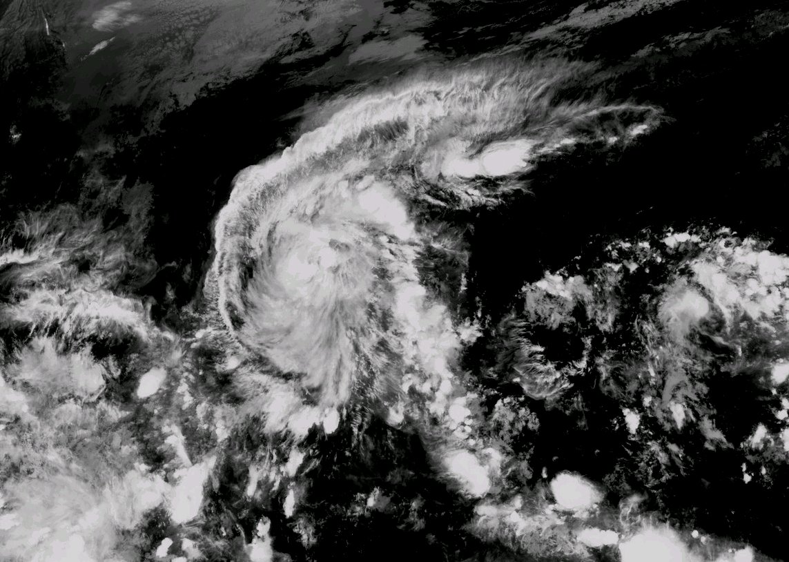
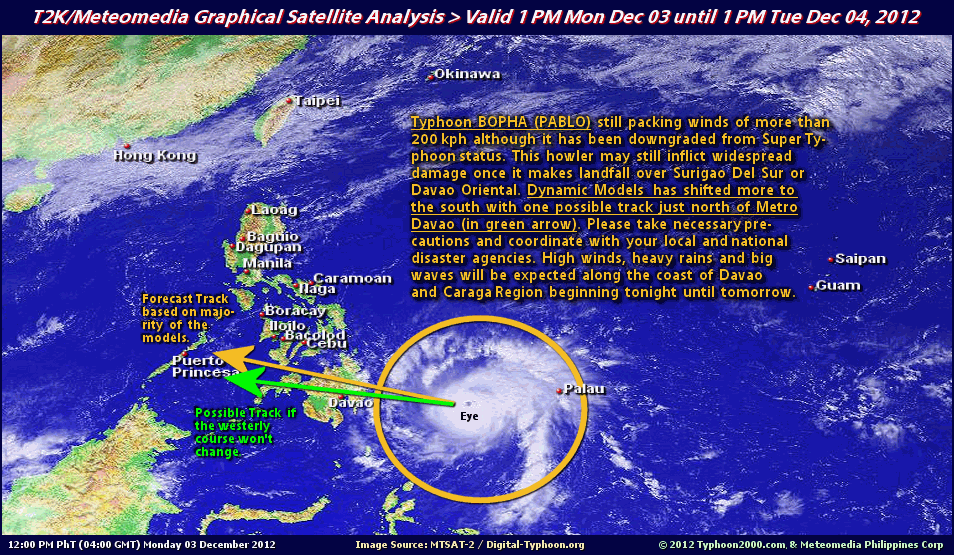
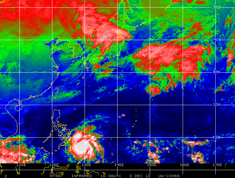
Quelle: http://weather.com.ph/announcements/sup ... umber-024a

Zum Glück schwächte sich der Supertaifun nach dem Landfall markant ab (von Cat. 5 auf Cat. 2 innert Stunden).

Dank frühzeitiger Evakuierungen soll offenbar Schlimmeres verhindert worden sein:
http://news.ph.msn.com/regional/eight-d ... hilippines

Gruss, Chris
Zuletzt geändert von Severestorms am Di 4. Dez 2012, 13:46, insgesamt 1-mal geändert.
Founder, Owner and Operator of SSWD - Engaged in Science & Research since 1997.
Follow @SturmarchivCH on Twitter to get accurate information about severe, extreme or unusual weather events in Switzerland - fast and reliable.


Urbi

Re: Super-Typhoon Bopha

Beitrag von Urbi »

Weitere Route:

Bild
+   fnmoc.navy.mil Tropical Cyclones


Nächster Landfall mit bis zu 195 km/h

Gruss
Urbi

Severestorms
Administrator
Beiträge: 6648
Registriert: Mo 20. Aug 2001, 17:21
Geschlecht: männlich
Wohnort: Zürich
Hat sich bedankt: 3765 Mal
Danksagung erhalten: 1660 Mal
Kontaktdaten:

Re: Super-Typhoon Bopha

Beitrag von Severestorms »

Severestorms hat geschrieben: Dank frühzeitiger Evakuierungen soll offenbar Schlimmeres verhindert worden sein:
http://news.ph.msn.com/regional/eight-d ... hilippines

Gruss, Chris
Wie befürchtet ist es trotz früher Warnungen und Massenevakuierungen zu Hunderten von Toten gekommen:
http://www.spiegel.de/panorama/mindeste ... 71075.html

:(

Gruss, Chris
Zuletzt geändert von Severestorms am Mi 5. Dez 2012, 13:22, insgesamt 1-mal geändert.
Founder, Owner and Operator of SSWD - Engaged in Science & Research since 1997.
Follow @SturmarchivCH on Twitter to get accurate information about severe, extreme or unusual weather events in Switzerland - fast and reliable.

Philippe Zimmerwald
Beiträge: 1637
Registriert: Fr 17. Aug 2001, 14:05
Wohnort: 3625 Heiligenschwendi
Danksagung erhalten: 884 Mal

Re: Super-Typhoon Bopha

Beitrag von Philippe Zimmerwald »

Kachelmanns Taifun-Warner sah das Übel kommen:

http://www.bernerzeitung.ch/panorama/le ... y/16467243

Grüsse
Philippe
Philippe Heiligenschwendi 1000m (ehemals Zimmerwald 899m)

Antworten