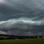
In den USA beginnt das Jahr mit einem Enhanced Risk für Unwetter in den Staaten Tennessee, Mississippi und Alabama. Das Risiko für Tornados in diesen Staaten liegt bei 10%:

Quelle: https://www.spc.noaa.gov/products/outlook/day1otlk.html (läuft ab).
In Zusammenarbeit mit meteoradar

Werbung

Quelle: https://www.spc.noaa.gov/products/outlook/day1otlk.html (läuft ab)...SUMMARY...
Severe thunderstorms are expected across portions of the Lower
Mississippi Valley, Mid-South, and Southeast on Thursday. Damaging
winds and a few tornadoes will be possible.
...Synopsis...
An elongated, positive-tilt upper trough will move from the Plains
across the Mississippi Valley, with a pronounced leading wave moving
from the Arklatex across the Ohio Valley during the day. Low
pressure will translate quickly northeastward from eastern Oklahoma
early this morning toward Ohio by 00Z ahead of a cold front.
Increasing southerly winds will help transport mid 60s F dewpoints
north across east Texas, Louisiana, Arkansas, Mississippi and
western Alabama, aiding destabilization. The cold front will move
rapidly east through Friday morning, crossing the Appalachians. The
combination of lift, strong shear, and sufficient instability will
likely result in severe wind gusts, and perhaps a few tornadoes
across the Enhanced Risk area during the afternoon and evening.

Quelle: https://www.spc.noaa.gov/products/outlook/day1otlk.html (läuft ab)...THERE IS A MODERATE RISK OF SEVERE THUNDERSTORMS ACROSS PARTS OF
SOUTHERN LOUISIANA AND SOUTHERN MISSISSIPPI...
...SUMMARY...
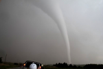
A regional severe weather outbreak, including potential for strong
tornadoes, is possible today into this evening over the Lower
Mississippi Valley and central Gulf Coast states.
Drohnenvideo: https://www.youtube.com/watch?v=SDXaWx8uqss"ENH" (for Enhanced: orange shaded area, which replaced the upper end of the SLGT category on October 22, 2014);

Werbung