Ob sich der aktuelle ICON-Lauf vom Montag hat inspirieren lassen? Oder ob das Modell einfach den Schreibenden mit einem netten Geburtstags-Gewitter beglücken möchte?
Die Gewittersaison legt morgen jedenfalls nochmals eine Zusatzschleife ein. Ganz so übel wie vorgestern muss es ja nicht wieder werden - "nett" würde reichen, etwas Starkregen und ein paar Blitze - aber MeteoSchweiz hat wiederum "kräftige Gewitter" in der aktuellen Prognose.
Gruss
Martin
Zuletzt geändert von Willi am Mi 10. Sep 2025, 23:22, insgesamt 2-mal geändert.
Ja, das Setup der aktuellen Modellläufe sieht praktisch identisch aus, so quasi 2.0... aber ob sich wieder eine Squall Line entwickelt und die gleichen Gebiete beglückt, wäre dann schon Zufall
MeteoSchweiz-Blog | 03. September 2025
Gewitter am Donnerstag
Nachdem der Mittwoch wettertechnisch ruhig verlief, kommt morgen Donnerstag im Zusammenhang mit einer Kaltfront wieder Bewegung in die Wetterküche. Wir schauen uns die Gewitter genauer an.
Danke Bernhard - wie immer ein sehr gut verfasster Blog, der gut zusammenfasst, welche Zutaten stimmen müssen, damit das Resultat "gelingt" - und wie rasch die Gewitter-Suppe auch versalzen werden kann.
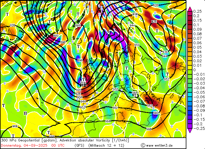
Auch der aktuelle ICON-Lauf bleibt auf der "Bow-Echo-Variante". Besonders augenfällig dabei auch die rasche West-Ost-Verlagerung; Genfer- zu Bodensee in knapp 3 Stunden. Das wäre Pi mal Daumen mal so eine Verlagerungsgeschwindigkeit von 80 km/h (im Kopf geschätzt). Das würde ruppig!
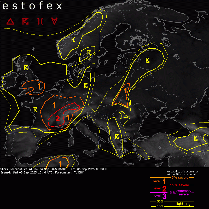
Issues regarding the final storm mode persist for this area as DMC activity approaches from the W during the afternoon. A more S-erly cross-Alpine flow increases lapse rates a bit especially towards SE Germany, where adequate BL moisture pushes MUCAPE in excess of 1000 J/kg. Some issues persist in NWP data regarding low-tropospheric mass response, as some data hints at more E/NE-erly BL flow up to the northern Swiss border with others keeping the E-erly BL flow component confined to SE Germany. With the mentioned flow above, confidence is high enough to expect a mixed (synoptic-scale) mass reponse/Alpine pumping event to keep BL flow out from the E/NE until the DMC activity approaches from the W during the afternoon/evening.
Over Switzerland, IFS/ICON both agree in a favorable CAPE/shear space ahead of the afternoon convection with 15 m/s at 3/6 km AGL with GFS running a bit weaker in the lower troposphere. In reality, shear should be a tad stronger along the complex orography.
We either see a structuring bowing segment ahead of an intensifying pressure wave/storm-internal RIJ, which affects W/N Switzerland with swaths of severe/damaging gusts, some hail and heavy rain. Or we see evolving/rapidly organizing convection along the orography, which shifts into NE Switzerland and afterwards into S Germany with swaths of damaging gusts. ID2 EPS data (probably over-confident) has a strong favor to the second solution, with EZ driven models (at least partially) to the first scenario. In addition, with the more discrete CI possibility (also expanding further N), we could also see more discrete storms affecting SW into CNTRL Germany with sufficient CAPE/shear for severe next to limited/spotty discrete storms over S/SE Germany ahead of the main show during late afternoon/evening.
For now, we expanded the French level 2 into S-Germany to account for numerous solutions (and despite mixed signals for the general setup). EPS and deterministic data however create a confined/favorable synoptic and mesoscale setup for a potential long-lived bowing system to cross parts of the Swiss/German level 2 area NE with widespread strong to severe gusts and some hail. In addition, if we can get the 25kt 0-2 km SR inflow pointing into a growing MCS, embedded temporal tornadic circulations cannot be ruled out.
Bernhard Oker hat geschrieben: ↑Mi 3. Sep 2025, 18:41MeteoSchweiz-Blog | 03. September 2025
Gewitter am Donnerstag
In der Nacht auf Donnerstag ziehen zuerst aus Westen Wolkenfelder auf die Alpennordseite. Erste Schauer sind möglich, besonders dem Jura entlang und in der Nordwestschweiz. Die Luft ist bereits feucht und hat eine gewisse Labilität, somit sind erste Gewitter durchaus möglich, wenn auch noch unwahrscheinlich.
In Bern (weder im Jura noch in der Nordwestschweiz gelegen), raubt mir bereits das zweite "unwahrscheinliche" Gewitter den Schlaf. Mir wachsen ob der lausigen Modellqualität von der Langfrist bis runter in die Kürzestfrist immer mehr graue Haare, insbesondere wenn ich an das bevorstehende GordonBennett-Rennen denke
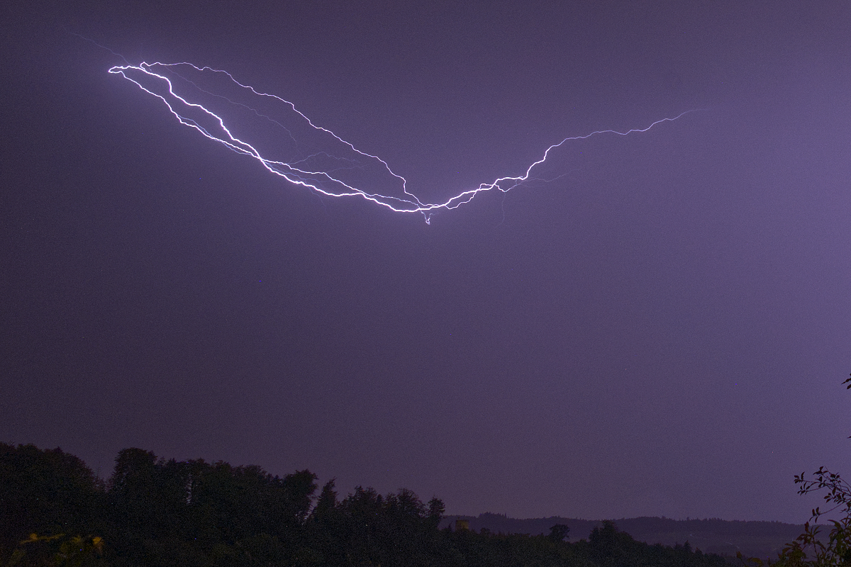
In Basel wir es immer dünkler von Westen bahnt sich was an, die ersten Tropfen fallen schon.
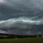
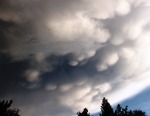
Vor etwa 1h gab es noch interessante WOlkenformationen, Wellenwolken.
mal schauen was da kommt...bin gespannt.
Der Aufzug mit Shelfcloud und einem sichtbaren Blitz vor dem Gewitter versprachen mehr als es dann am Schluss war.
Etwas Wind und paar Minuten starker Regen dazu gezählte 5 Donner. Mochte etwa das Gewitter Basel nicht? Die Zelle baut im südlichen Teil (über Liestal) realtiv rasch an und löst sich über Basel sozusagen auf.
Zuletzt geändert von Marco (Oberfrick) am Do 4. Sep 2025, 09:48, insgesamt 1-mal geändert.
Aus dem Schönen WINTERthur-Seen 480m.ü.M.
Seit 2017 im Frickital Zuhause