
https://www.srf.ch/meteo/meteo-stories/ ... d-erwartet
Was sagen und denken die ExpertInnen hier? International wird von möglichem Super El Niño gesprochen.
z.B.
https://www.severe-weather.eu/long-rang ... europe-fa/

Werbung
2026 Super El Niño?
-
oneworldflyer
- Beiträge: 120
- Registriert: So 23. Mai 2021, 10:45
- Geschlecht: männlich
- Wohnort: 3295 Rüti bei Büren BE
- Hat sich bedankt: 32 Mal
- Danksagung erhalten: 65 Mal
-
helios
- Beiträge: 607
- Registriert: So 10. Mär 2013, 20:31
- Geschlecht: männlich
- Wohnort: Serravalle TI
- Hat sich bedankt: 767 Mal
- Danksagung erhalten: 564 Mal
- Kontaktdaten:
Re: 2026 Super El Niño?
Ich bin kein Experte, aber die Meeresoberflächentemperatur geht leider wieder in Richtung Rekordwerte.
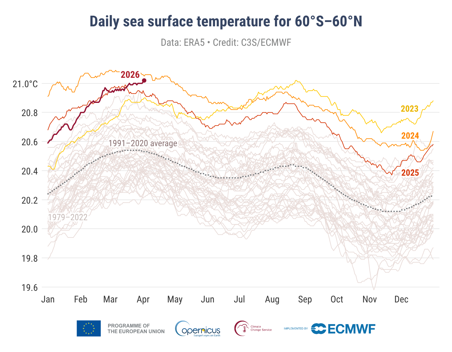
https://climate.copernicus.eu/sea-surfa ... vels-march
https://climate.copernicus.eu/sea-surfa ... vels-march
-
Federwolke

- Moderator
- Beiträge: 9695
- Registriert: Mo 20. Aug 2001, 23:47
- Geschlecht: weiblich
- Wohnort: 3074 Muri bei Bern
- Hat sich bedankt: 1991 Mal
- Danksagung erhalten: 9982 Mal
- Kontaktdaten:
Re: 2026 Super El Niño?
Man darf gespannt sein, was das (weltweit) für Auswirkungen hat. Wäre alles Spekulation, weil noch nie auch nur ansatzweise dagewesen:
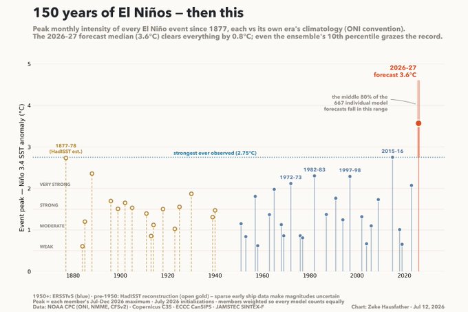
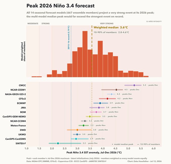
Quelle und mehr Details: https://www.theclimatebrink.com/p/the-s ... -nino-ever
Quelle und mehr Details: https://www.theclimatebrink.com/p/the-s ... -nino-ever
Grüsslis
Fabienne (Muri bei Bern, 560 m)
https://www.fotometeo.ch
https://www.orniwetter.info
https://fotometeo.smugmug.com
https://bsky.app/profile/fotometeo-ch.bsky.social
Fabienne (Muri bei Bern, 560 m)
https://www.fotometeo.ch
https://www.orniwetter.info
https://fotometeo.smugmug.com
https://bsky.app/profile/fotometeo-ch.bsky.social
-
oneworldflyer
- Beiträge: 120
- Registriert: So 23. Mai 2021, 10:45
- Geschlecht: männlich
- Wohnort: 3295 Rüti bei Büren BE
- Hat sich bedankt: 32 Mal
- Danksagung erhalten: 65 Mal
Re: 2026 Super El Niño?
https://www.severe-weather.eu/long-rang ... europe-fa/
Europe Winter Trends: Westerly Flow and a Milder Pattern
Europe is usually not the first in a direct impact line from the tropics. But in a season with a Super El Niño paired with a positive IOD, the research above already showed an amplified low-pressure pattern over the North Atlantic or northwestern Europe.
Below is the very latest early and mid-winter pattern forecast for Europe, by ECMWF. It shows an almost exact pattern as suggested by the research above, with a high-pressure ridge from the south and a low-pressure area over the northwestern and northern parts.
An amplified westerly flow also brings more moisture into the continent, which is the driver of the precipitation forecast below. You can see above-normal precipitation over the December-February period, driven by westerly moisture transport and the low-pressure system over the north/northwest.
-
Dani (Niederurnen)
- Administrator
- Beiträge: 4024
- Registriert: Fr 31. Aug 2001, 20:39
- Geschlecht: männlich
- Wohnort: 8867 Niederurnen
- Hat sich bedankt: 1105 Mal
- Danksagung erhalten: 460 Mal
- Kontaktdaten:
Re: 2026 Super El Niño?
Die Auswirkungen dieser beiden Phänomene konnte ich in 2016 in Singapur selber erleben. Ein Land wo es sonst nahezu täglich mal regnet wo es dadurch in einem ganzen Monat (März) nur noch 6.2mm Regen an einer Messstation gab, dazu Buschbrände an einzelnen Orten.
Ob sich über dem Mittelmeer / Nordafrika wirklich eine solche Hochdruckanomalie entwickeln kann wird sich weisen, ich weiss nicht wie gut das Modell mit den warmen Temperaturen im Mittelmeer zurecht kommt.
Ob sich über dem Mittelmeer / Nordafrika wirklich eine solche Hochdruckanomalie entwickeln kann wird sich weisen, ich weiss nicht wie gut das Modell mit den warmen Temperaturen im Mittelmeer zurecht kommt.
Neu nicht mehr in der Nebelsuppe von Uster sondern in im sonnigen Glarnerland
-
Tinu (Männedorf)

- Beiträge: 4185
- Registriert: Fr 29. Jul 2005, 16:35
- Geschlecht: männlich
- Wohnort: 8708 Männedorf
- Hat sich bedankt: 814 Mal
- Danksagung erhalten: 2072 Mal
Re: 2026 Super El Niño?
In dem Zusammenhang noch mein Artikel zum Thema barrierefrei fürs Sturmforum:
Hier gehts zum Original (Abo): https://www.tagesanzeiger.ch/el-nino-20 ... 0642717432
Bereits jetzt setzt der diesjährige El Niño neue Massstäbe. Auf seinem Höhepunkt im Spätherbst kann er weltweit extreme Wetteranomalien wie Dürren, Stürme und Überschwemmungen auslösen.
Während die Schweiz und weite Teile Europas nach wie vor unter den Auswirkungen eines historischen Hitzesommers zu leiden haben, macht sich im tropischen Pazifik ein anderes markantes Klima- und Wetterphänomen bemerkbar. El Niño ist in vollem Gang. Das bedeutet: Zwischen der Küste Ecuadors und der polynesischen Inselwelt hat sich das oberflächennahe Meerwasser des Pazifiks aussergewöhnlich stark erwärmt.
Die Wassertemperaturen in der sogenannten Niño-3.4-Region, die sich im zentralen und östlichen Pazifik auf Höhe des Äquators befindet, liegen derzeit 2,7 Grad über dem langjährigen Klimamittel. Da diese Region als Taktgeberin für die Entwicklung und Stärke des Phänomens gilt, lässt sich mit Sicherheit sagen, dass die Welt es mit einem El Niño zu tun hat, der bereits jetzt zu den stärksten seit Messbeginn gehört.
Stärkster El Niño mit «unvorstellbarem Vorsprung»
Experten wie der US-amerikanische Klimawissenschaftler Zeke Hausfather, der für die Non-Profit-Organisation Berkeley Earth forscht, gehen davon aus, dass sich das Phänomen bis zum Herbst weiter verstärken und eine bisher nie da gewesene Stärke erreichen wird. «Es sieht so aus, als ob der diesjährige El Niño nicht nur das stärkste Ereignis seit Beginn verlässlicher Aufzeichnungen wird – er könnte am Ende sogar mit einem unvorstellbaren Vorsprung der Stärkste sein», sagt Hausfather.
Die aktuellen Messungen deuten gemäss Hausfather darauf hin, dass die Warmwasseranomalie in der Niño-3.4-Region im November 3,9 Grad erreichen wird. «Die Klimamodelle prognostizieren etwas, das ausserhalb des Rahmens von allem liegt, was wir jemals beobachtet haben», sagt er. Zum Vergleich: Der letzte sehr starke El Niño ereignete sich im Jahr 2015/2016 und erreichte in der Niño-3.4-Region eine positive Temperaturabweichung von «nur» 3 Grad.
Windsysteme verändern sich und damit auch das Wetter
Ausgelöst wird das El-Niño-Phänomen durch eine Veränderung der dem Äquator entlang von Ost nach West wehenden Passatwinde. Der Passat sorgt normalerweise dafür, dass viel Feuchtigkeit über den Pazifik verfrachtet wird. Diese Feuchtigkeit regnet sich dann über der Inselwelt Südostasiens aus und sorgt dort während der Regenzeit für intensive Niederschläge. Gleichzeitig hält sich im Ostpazifik ein Hochdruckgebiet, das für Trockenheit an den Küsten Perus und Chiles sorgt.
Bei einem El Niño kommt der Feuchtetransport durch die Abschwächung der Passatwinde ins Stocken. Im Extremfall kann sich das Zirkulationsmuster sogar umkehren. Das hat massive Auswirkungen auf das Wetter: Über Südostasien herrscht ungewöhnliche Trockenheit, an den Küsten Perus und Chiles regnet es ergiebig. Die normalerweise vor der südamerikanischen Küste herrschenden Kaltwasserströme im Pazifik werden durch deutlich wärmeres Wasser verdrängt.
El Niño stellt das Wetter auf den Kopf
Damit sind die potenziellen Auswirkungen von El Nino aber nur ansatzweise erklärt. Da die maritimen Strömungssysteme global verbunden sind, wirkt sich El Niño vor allem in den Tropen und Subtropen – praktisch rund um den gesamten Erdball – aus. Bei vergangenen Ereignissen kam es zu Wetterextremen in Form von Dürren oder Überschwemmungen in Afrika, Brasilien oder China. Kurzum: El Niño stellt das Wetter auf den Kopf, und zwar mit dramatischen ökologischen und wirtschaftlichen Konsequenzen. Gemäss Schätzungen der Vereinten Nationen könnten 2027 bis zu 50 Millionen Menschen zusätzlich an Hunger leiden.
Dabei gilt: Je stärker El Niño ist, desto intensiver sind die Auswirkungen. Daher muss im Herbst damit gerechnet werden, dass die Welt gebietsweise extreme Wetteranomalien erleben wird. «In gewissen Regionen macht sich das bereits jetzt bemerkbar», sagt Nicolas Gruber, Klimawissenschaftler und Meeresforscher an der ETH Zürich.
Eine typische Auswirkung von El Niño zeige sich vor der Küste Perus. Dort verschwinden wegen der markanten Erwärmung des Meerwassers die grossen, eigentlich kaltwasserliebenden Fischschwärme. Die Regierung Perus hat bereits darauf reagiert: So ist der Fang von Sardellen (Anchovis) seit Juni ausgesetzt. Für die Fischerei ist das mit erheblichen Konsequenzen verbunden, weil der Sardellenfang und die damit verbundene Produktion von Fischöl ein wichtiges Standbein der Wirtschaft des Landes darstellen.
Weniger Hurrikane im Atlantik
Auch im Atlantik meinen Experten die Auswirkungen von El Niño bereits spüren zu können. «Auch wenn in den letzten Tagen etwas mehr Aktivität aufgekommen ist, so ist die Zahl der Tropenstürme bisher viel tiefer als normalerweise üblich», bilanziert US-Hurrikanexperte und Meteorologe Matt Lanza in einem ausführlichen Blog zum Thema. Die Hurrikansaison auf dem Atlantik beginnt Anfang Juni und dauert bis Ende November.
Die derzeitige Ruhe sei zwar bis zu einem gewissen Grad dadurch erklärbar, dass die Hurrikansaison noch jung sei. Allerdings geht Lanza davon aus, dass auch El Niño eine wichtige Rolle spielt. Denn: Das Klimaphänomen sorge dafür, dass im tropischen Bereich des Atlantiks stärkere Scherwinde in der Atmosphäre aufträten. Das bedeutet: Der Wind ändert mit zunehmender Höhe seine Richtung und Geschwindigkeit. «Das wirkt der Entwicklung von Tropenstürmen und Hurrikanen entgegen», erklärt er.
Lanza vermutet, dass die diesjährige Hurrikansaison auf dem Atlantik wegen El Niño kaum in Fahrt kommen wird. Das bedeutet: Weniger Stürme als üblich und somit auch weniger starke Stürme als üblich.
Höhepunkt im Dezember, Fortgang bis nächsten Sommer
Seinen Höhepunkt erreichen wird das aktuelle El-Nino-Ereignis vermutlich um die Weihnachtszeit. Gemäss Nicolas Gruber ist das typisch. Daher rührt auch die Bezeichnung des Phänomens: Im Spanischen bedeutet El Niño kleiner Junge – oder Christkind. Weil es so stark ist, dürfte sich das Phänomen auch lange hinziehen. «Vermutlich wird dieser El Niño bis in den nächsten Sommer hinein anhalten», sagt Gruber.
Im Verlauf der zweiten Jahreshälfte 2027 dürfte sich das Zirkulationsmuster über dem Pazifik dann wieder verändern. Üblicherweise geht das nach dem Zusammenbruch von El Niño relativ rasch. Die Experten gehen davon aus, dass auf den starken El Niño in der zweiten Hälfte des Jahres 2027 eine ausgeprägte La-Niña-Phase folgen wird. La Niña ist das Gegenteil von El Niño. Das bedeutet: Das Oberflächenwasser im zentralen und östlichen Pazifik kühlt sich ab und die Windsysteme – und auch der Transport von Feuchtigkeit über den Ozean von Südamerika Richtung Asien – verstärken sich.
Kein Zusammenhang mit dem Hitzesommer 2026
Die Hitze und die Trockenheit, die in diesem Sommer vor allem in West- und Mitteleuropa herrschten, stehen nicht im Zusammenhang mit dem El-Niño-Phänomen. Zwar wird in diesem Bereich intensiv geforscht, und auch zu Beginn dieses Sommers wurde über mögliche Einflüsse von El Niño auf den europäischen Sommer gemutmasst.
Allerdings setzte der diesjährige El Niño erst im Verlauf der zweiten Sommerhälfte ein – zu diesem Zeitpunkt war in Westeuropa bereits die zweite Hitzewelle in vollem Gang. Gemäss Nicolas Gruber gilt nach wie vor: «Ein Einfluss auf unser Sommerwetter ist nicht nachweisbar.» Weitaus relevanter für unser Wetter seien die Prozesse über dem Nordatlantik.
Dennoch wird bereits wieder darüber spekuliert, ob und wie sich El Niño auf das hiesige Winterwetter auswirken könnte. Meteorologe Andrej Flis von Severe Weather Europe sagt, dass in West- und Mitteleuropa wegen El Niño sowohl der Spätherbst als auch der Winter mild, windig und sehr nass ausfallen könnten. Auch er betont, dass das Einflusssignal von El Niño für Europa zwar schwer nachweisbar, im Winterhalbjahr allerdings etwas robuster sei als im Sommer. Den ausgetrockneten Ländern West- und Mitteleuropas – zu denen die Schweiz zählt – käme es zugute, wenn sich Flis Prognose als richtig erwiese.
Weniger Unsicherheiten herrschen bezüglich der Auswirkungen von El Niño auf die globalen Temperaturverhältnisse. Die Erfahrungen der Vergangenheit zeigen, dass die weltweite Durchschnittstemperatur bei einem starken El Niño um 0,2 bis 0,3 Grad erhöht wird – ein Wert, der sich auf die Klimaerwärmung aufsetzt. «2027 wird daher mit hoher Wahrscheinlichkeit ein rekordwarmes Jahr werden», sagt Nicolas Gruber.
Hier gehts zum Original (Abo): https://www.tagesanzeiger.ch/el-nino-20 ... 0642717432
Bereits jetzt setzt der diesjährige El Niño neue Massstäbe. Auf seinem Höhepunkt im Spätherbst kann er weltweit extreme Wetteranomalien wie Dürren, Stürme und Überschwemmungen auslösen.
Während die Schweiz und weite Teile Europas nach wie vor unter den Auswirkungen eines historischen Hitzesommers zu leiden haben, macht sich im tropischen Pazifik ein anderes markantes Klima- und Wetterphänomen bemerkbar. El Niño ist in vollem Gang. Das bedeutet: Zwischen der Küste Ecuadors und der polynesischen Inselwelt hat sich das oberflächennahe Meerwasser des Pazifiks aussergewöhnlich stark erwärmt.
Die Wassertemperaturen in der sogenannten Niño-3.4-Region, die sich im zentralen und östlichen Pazifik auf Höhe des Äquators befindet, liegen derzeit 2,7 Grad über dem langjährigen Klimamittel. Da diese Region als Taktgeberin für die Entwicklung und Stärke des Phänomens gilt, lässt sich mit Sicherheit sagen, dass die Welt es mit einem El Niño zu tun hat, der bereits jetzt zu den stärksten seit Messbeginn gehört.
Stärkster El Niño mit «unvorstellbarem Vorsprung»
Experten wie der US-amerikanische Klimawissenschaftler Zeke Hausfather, der für die Non-Profit-Organisation Berkeley Earth forscht, gehen davon aus, dass sich das Phänomen bis zum Herbst weiter verstärken und eine bisher nie da gewesene Stärke erreichen wird. «Es sieht so aus, als ob der diesjährige El Niño nicht nur das stärkste Ereignis seit Beginn verlässlicher Aufzeichnungen wird – er könnte am Ende sogar mit einem unvorstellbaren Vorsprung der Stärkste sein», sagt Hausfather.
Die aktuellen Messungen deuten gemäss Hausfather darauf hin, dass die Warmwasseranomalie in der Niño-3.4-Region im November 3,9 Grad erreichen wird. «Die Klimamodelle prognostizieren etwas, das ausserhalb des Rahmens von allem liegt, was wir jemals beobachtet haben», sagt er. Zum Vergleich: Der letzte sehr starke El Niño ereignete sich im Jahr 2015/2016 und erreichte in der Niño-3.4-Region eine positive Temperaturabweichung von «nur» 3 Grad.
Windsysteme verändern sich und damit auch das Wetter
Ausgelöst wird das El-Niño-Phänomen durch eine Veränderung der dem Äquator entlang von Ost nach West wehenden Passatwinde. Der Passat sorgt normalerweise dafür, dass viel Feuchtigkeit über den Pazifik verfrachtet wird. Diese Feuchtigkeit regnet sich dann über der Inselwelt Südostasiens aus und sorgt dort während der Regenzeit für intensive Niederschläge. Gleichzeitig hält sich im Ostpazifik ein Hochdruckgebiet, das für Trockenheit an den Küsten Perus und Chiles sorgt.
Bei einem El Niño kommt der Feuchtetransport durch die Abschwächung der Passatwinde ins Stocken. Im Extremfall kann sich das Zirkulationsmuster sogar umkehren. Das hat massive Auswirkungen auf das Wetter: Über Südostasien herrscht ungewöhnliche Trockenheit, an den Küsten Perus und Chiles regnet es ergiebig. Die normalerweise vor der südamerikanischen Küste herrschenden Kaltwasserströme im Pazifik werden durch deutlich wärmeres Wasser verdrängt.
El Niño stellt das Wetter auf den Kopf
Damit sind die potenziellen Auswirkungen von El Nino aber nur ansatzweise erklärt. Da die maritimen Strömungssysteme global verbunden sind, wirkt sich El Niño vor allem in den Tropen und Subtropen – praktisch rund um den gesamten Erdball – aus. Bei vergangenen Ereignissen kam es zu Wetterextremen in Form von Dürren oder Überschwemmungen in Afrika, Brasilien oder China. Kurzum: El Niño stellt das Wetter auf den Kopf, und zwar mit dramatischen ökologischen und wirtschaftlichen Konsequenzen. Gemäss Schätzungen der Vereinten Nationen könnten 2027 bis zu 50 Millionen Menschen zusätzlich an Hunger leiden.
Dabei gilt: Je stärker El Niño ist, desto intensiver sind die Auswirkungen. Daher muss im Herbst damit gerechnet werden, dass die Welt gebietsweise extreme Wetteranomalien erleben wird. «In gewissen Regionen macht sich das bereits jetzt bemerkbar», sagt Nicolas Gruber, Klimawissenschaftler und Meeresforscher an der ETH Zürich.
Eine typische Auswirkung von El Niño zeige sich vor der Küste Perus. Dort verschwinden wegen der markanten Erwärmung des Meerwassers die grossen, eigentlich kaltwasserliebenden Fischschwärme. Die Regierung Perus hat bereits darauf reagiert: So ist der Fang von Sardellen (Anchovis) seit Juni ausgesetzt. Für die Fischerei ist das mit erheblichen Konsequenzen verbunden, weil der Sardellenfang und die damit verbundene Produktion von Fischöl ein wichtiges Standbein der Wirtschaft des Landes darstellen.
Weniger Hurrikane im Atlantik
Auch im Atlantik meinen Experten die Auswirkungen von El Niño bereits spüren zu können. «Auch wenn in den letzten Tagen etwas mehr Aktivität aufgekommen ist, so ist die Zahl der Tropenstürme bisher viel tiefer als normalerweise üblich», bilanziert US-Hurrikanexperte und Meteorologe Matt Lanza in einem ausführlichen Blog zum Thema. Die Hurrikansaison auf dem Atlantik beginnt Anfang Juni und dauert bis Ende November.
Die derzeitige Ruhe sei zwar bis zu einem gewissen Grad dadurch erklärbar, dass die Hurrikansaison noch jung sei. Allerdings geht Lanza davon aus, dass auch El Niño eine wichtige Rolle spielt. Denn: Das Klimaphänomen sorge dafür, dass im tropischen Bereich des Atlantiks stärkere Scherwinde in der Atmosphäre aufträten. Das bedeutet: Der Wind ändert mit zunehmender Höhe seine Richtung und Geschwindigkeit. «Das wirkt der Entwicklung von Tropenstürmen und Hurrikanen entgegen», erklärt er.
Lanza vermutet, dass die diesjährige Hurrikansaison auf dem Atlantik wegen El Niño kaum in Fahrt kommen wird. Das bedeutet: Weniger Stürme als üblich und somit auch weniger starke Stürme als üblich.
Höhepunkt im Dezember, Fortgang bis nächsten Sommer
Seinen Höhepunkt erreichen wird das aktuelle El-Nino-Ereignis vermutlich um die Weihnachtszeit. Gemäss Nicolas Gruber ist das typisch. Daher rührt auch die Bezeichnung des Phänomens: Im Spanischen bedeutet El Niño kleiner Junge – oder Christkind. Weil es so stark ist, dürfte sich das Phänomen auch lange hinziehen. «Vermutlich wird dieser El Niño bis in den nächsten Sommer hinein anhalten», sagt Gruber.
Im Verlauf der zweiten Jahreshälfte 2027 dürfte sich das Zirkulationsmuster über dem Pazifik dann wieder verändern. Üblicherweise geht das nach dem Zusammenbruch von El Niño relativ rasch. Die Experten gehen davon aus, dass auf den starken El Niño in der zweiten Hälfte des Jahres 2027 eine ausgeprägte La-Niña-Phase folgen wird. La Niña ist das Gegenteil von El Niño. Das bedeutet: Das Oberflächenwasser im zentralen und östlichen Pazifik kühlt sich ab und die Windsysteme – und auch der Transport von Feuchtigkeit über den Ozean von Südamerika Richtung Asien – verstärken sich.
Kein Zusammenhang mit dem Hitzesommer 2026
Die Hitze und die Trockenheit, die in diesem Sommer vor allem in West- und Mitteleuropa herrschten, stehen nicht im Zusammenhang mit dem El-Niño-Phänomen. Zwar wird in diesem Bereich intensiv geforscht, und auch zu Beginn dieses Sommers wurde über mögliche Einflüsse von El Niño auf den europäischen Sommer gemutmasst.
Allerdings setzte der diesjährige El Niño erst im Verlauf der zweiten Sommerhälfte ein – zu diesem Zeitpunkt war in Westeuropa bereits die zweite Hitzewelle in vollem Gang. Gemäss Nicolas Gruber gilt nach wie vor: «Ein Einfluss auf unser Sommerwetter ist nicht nachweisbar.» Weitaus relevanter für unser Wetter seien die Prozesse über dem Nordatlantik.
Dennoch wird bereits wieder darüber spekuliert, ob und wie sich El Niño auf das hiesige Winterwetter auswirken könnte. Meteorologe Andrej Flis von Severe Weather Europe sagt, dass in West- und Mitteleuropa wegen El Niño sowohl der Spätherbst als auch der Winter mild, windig und sehr nass ausfallen könnten. Auch er betont, dass das Einflusssignal von El Niño für Europa zwar schwer nachweisbar, im Winterhalbjahr allerdings etwas robuster sei als im Sommer. Den ausgetrockneten Ländern West- und Mitteleuropas – zu denen die Schweiz zählt – käme es zugute, wenn sich Flis Prognose als richtig erwiese.
Weniger Unsicherheiten herrschen bezüglich der Auswirkungen von El Niño auf die globalen Temperaturverhältnisse. Die Erfahrungen der Vergangenheit zeigen, dass die weltweite Durchschnittstemperatur bei einem starken El Niño um 0,2 bis 0,3 Grad erhöht wird – ein Wert, der sich auf die Klimaerwärmung aufsetzt. «2027 wird daher mit hoher Wahrscheinlichkeit ein rekordwarmes Jahr werden», sagt Nicolas Gruber.
Tinu (Männedorf ZH, 422 m ü. M)
Gewitter und Sturm = erhöhter Pulsschlag
Föhn-fasziniert
Gewitter und Sturm = erhöhter Pulsschlag
Föhn-fasziniert
-
oneworldflyer
- Beiträge: 120
- Registriert: So 23. Mai 2021, 10:45
- Geschlecht: männlich
- Wohnort: 3295 Rüti bei Büren BE
- Hat sich bedankt: 32 Mal
- Danksagung erhalten: 65 Mal
Re: 2026 Super El Niño?
El Niño hätte keinen Einfluss auf die Schweiz:
https://www.srf.ch/wissen/klimawandel/s ... bevorsteht
https://www.srf.ch/wissen/klimawandel/s ... bevorsteht
-
Federwolke
- Moderator
- Beiträge: 9695
- Registriert: Mo 20. Aug 2001, 23:47
- Geschlecht: weiblich
- Wohnort: 3074 Muri bei Bern
- Hat sich bedankt: 1991 Mal
- Danksagung erhalten: 9982 Mal
- Kontaktdaten:
Re: 2026 Super El Niño?
Klar. Eine Erklärung, wie der Nordatlantik durch den Nordpazifik und dieser wiederum von El Niño beeinflusst wird, würde das SRF-Publikum (möglicherweise schon die Wissenschaftsredaktorin) überfordern. Also besser gleich die Abkürzung nehmen. Hat jemand "Bildungsauftrag" gerufen? Den überlässt man dann besser den Privaten, auch wenn die dafür nicht bezahlt werden.Auf das Wetter in Europa hat «El Niño» so gut wie keinen Einfluss. Hierfür ist das Geschehen über dem Nordatlantik viel wichtiger.
Grüsslis
Fabienne (Muri bei Bern, 560 m)
https://www.fotometeo.ch
https://www.orniwetter.info
https://fotometeo.smugmug.com
https://bsky.app/profile/fotometeo-ch.bsky.social
Fabienne (Muri bei Bern, 560 m)
https://www.fotometeo.ch
https://www.orniwetter.info
https://fotometeo.smugmug.com
https://bsky.app/profile/fotometeo-ch.bsky.social
-
Tinu (Männedorf)
- Beiträge: 4185
- Registriert: Fr 29. Jul 2005, 16:35
- Geschlecht: männlich
- Wohnort: 8708 Männedorf
- Hat sich bedankt: 814 Mal
- Danksagung erhalten: 2072 Mal
Re: 2026 Super El Niño?
Also soweit ich es beurteilen kann, ist die Aussage "El Nino hat keinen Einfluss auf die Schweiz" so formuliert mit Sicherheit falsch. Er hat definitiv einen Einfluss auf unser Wetter. Die Frage ist halt wie immer: Wie stark ist der Einfluss? Und wie wirkt sich das Ganze am Ende aus? Da steht sicher noch viel Forschungsarbeit bevor. Aber sogar die Experten an der ETH, die ich kenne, und die sich mit dem Thema beschäftigen, würden einen Einfluss wohl niemals kategorisch ausschliessen.
Was korrekt ist: Atmosphärische Telekonnektionen sind mit Sicherheit etwas vom kompliziertesten, was es gibt. Daher ist der "Glatteisfaktor" in dieser Disziplin enorm hoch.
Was korrekt ist: Atmosphärische Telekonnektionen sind mit Sicherheit etwas vom kompliziertesten, was es gibt. Daher ist der "Glatteisfaktor" in dieser Disziplin enorm hoch.
Tinu (Männedorf ZH, 422 m ü. M)
Gewitter und Sturm = erhöhter Pulsschlag
Föhn-fasziniert
Gewitter und Sturm = erhöhter Pulsschlag
Föhn-fasziniert
-
Federwolke
- Moderator
- Beiträge: 9695
- Registriert: Mo 20. Aug 2001, 23:47
- Geschlecht: weiblich
- Wohnort: 3074 Muri bei Bern
- Hat sich bedankt: 1991 Mal
- Danksagung erhalten: 9982 Mal
- Kontaktdaten:
Re: 2026 Super El Niño?
Anders der DWD. Dort wird wenigstens erklärt, weshalb die Prognose der Auswirkungen von El Niño-Ereignissen auf Europa von Fall zu Fall abhängig und deshalb schwierig ist: https://www.dwd.de/DE/wetter/thema_des_ ... /8/23.htmlFederwolke hat geschrieben: Do 20. Aug 2026, 12:51 Eine Erklärung, wie der Nordatlantik durch den Nordpazifik und dieser wiederum von El Niño beeinflusst wird, würde das SRF-Publikum (möglicherweise schon die Wissenschaftsredaktorin) überfordern. Also besser gleich die Abkürzung nehmen.
Einmal mehr kann man davon ausgehen, dass wir "überrascht" werden, weil der Ausgangszustand bisher noch nie dagewesen ist.
Grüsslis
Fabienne (Muri bei Bern, 560 m)
https://www.fotometeo.ch
https://www.orniwetter.info
https://fotometeo.smugmug.com
https://bsky.app/profile/fotometeo-ch.bsky.social
Fabienne (Muri bei Bern, 560 m)
https://www.fotometeo.ch
https://www.orniwetter.info
https://fotometeo.smugmug.com
https://bsky.app/profile/fotometeo-ch.bsky.social