Hallo
Habe mir die Karten mal etwas angeschaut und werde nicht ganz schlüssig ob es was wird.
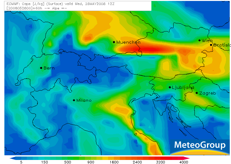
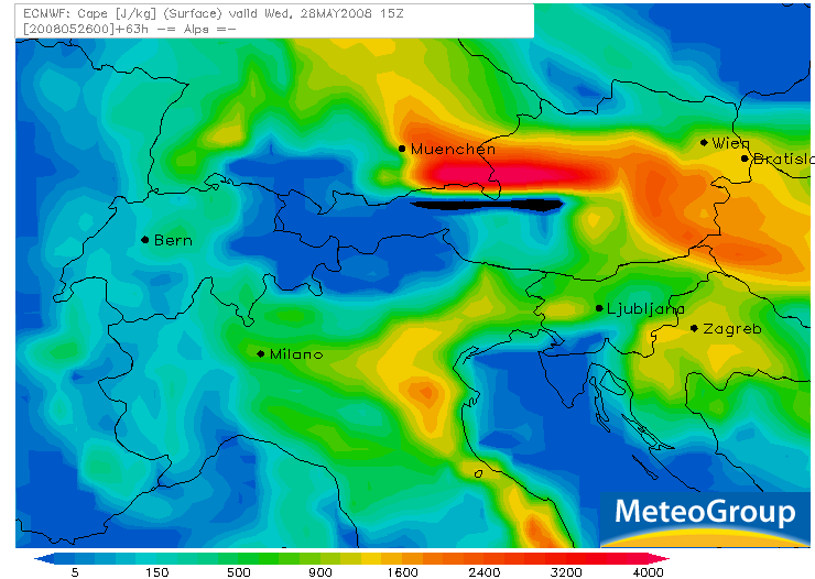
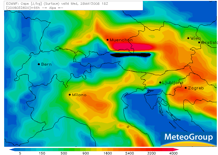
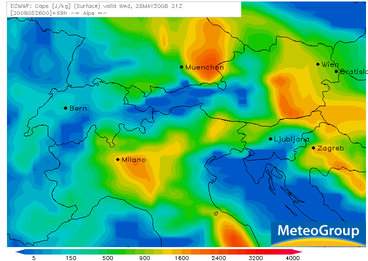
ECMWF Lauf von heute 00Z für Mittwoch:
CAPE 12Z
CAPE 15Z
CAPE 18Z
CAPE 21Z
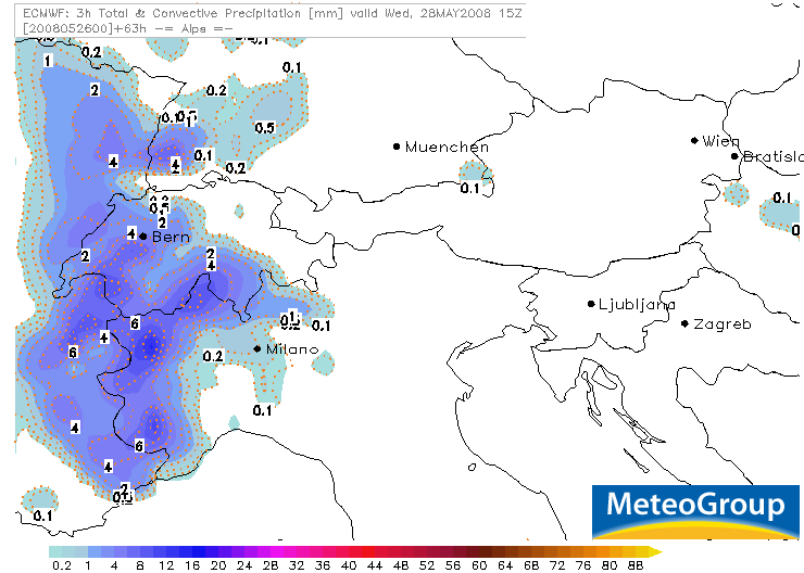
Niederschlag 12-15Z (nach 15Z Auflösung des Niederschlaggebietes)
In der Ostschweiz demnach keine Gewitter...
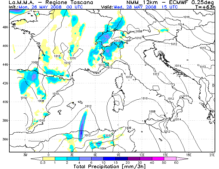
LaMMA in der Ostschweiz auch mehrheitlich trocken,
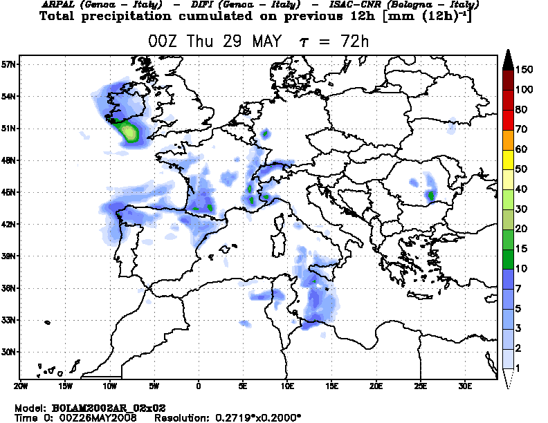
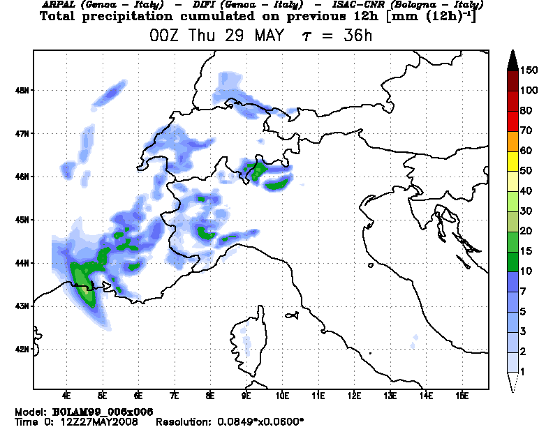
Bolam hingegen im ganzen Mittelland Niederschläge.
Werde Morgen dann entscheiden ob ich den Mittwoch Nachmittag frei nehme für ein Chasing...
Gruss
Bernhard

Werbung
Föhnsturm, Saharasand und Fast-Gewitter am 28.05.2008
-
Bernhard Oker

- Moderator
- Beiträge: 6515
- Registriert: Do 16. Aug 2001, 11:02
- Geschlecht: männlich
- Wohnort: 8902 Urdorf
- Hat sich bedankt: 1863 Mal
- Danksagung erhalten: 3108 Mal
-
Marco (Bettlach)
Gewitter am 28.05.2008
Ist nicht erst der Donnerstag der DONNERstag? Jedenfalls gestern im Meteo erwähnten sie starke Gewitter inkl. Hagel.
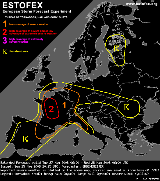
Extended Forecast
Valid: Tue 27 May 2008 06:00 to Wed 28 May 2008 06:00 UTC
Issued: Sun 25 May 2008 20:25
Forecaster: GROENEMEIJER
SYNOPSIS
East of the large-scale trough over the Bay of Biscay and Iberia a shortwave trough moves northward from the western Mediterranean Sea to central France. This shortwave is embedded in a strong southerly jet with speeds of 30-35 m/s at 500 hPa. A surface low is projected to move from near the Balearic Islands to Brittany.
DISCUSSION
Level 1 and 2 areas...
Widespread convective precipitation is expected over NE Spain and SE France in an area of upward vertical motion ahead of the aforementioned low pressure centre. Those embedded storms will probably be elevated, but steep lapse rates and strong low-level winds could still produce isolated severe hail and strong to severe gusts.
A warm front is expected to stretch from the Pyrenees to the Benelux countries. On its warm side dry air is advected northwestward out of the Alpine region into France. The evolution of the preciptation and cloudiness across southern France is hard to forecast, but per GFS this should shift northwestward to western France in concert with the frontal zone. This may leave an area in its wake where the sun has opportunity to heat the boundary layer. This could potentially create some surface-based instability in a region with large low level hodographs (300 m2/s2 SRH) and create a threat of strong tornadoes. In case low-level instability remains too limited for surface-based tornadic storms, they will still be likely to produce rather widespread severe gusts, given the already strong 25 m/s wind speeds at 850 hPa. Possibly, enough forcing will be available for a well-defined squall-line to move northward more or less across the area indicated as level 2.
An open question is to what extent storms will form further north along the warm front across NW france and the Benelux countries. It is not unthinkable that, during the late afternoon and evening, some storms develop there also. Given the high storm-relative helicity that is forecast, these may develop into supercells with a threat of hail, damaging gusts and tornadoes as well. Currently, our best estimate is that surface-based storms will mostly be restricted to central and W-central France until early evening, but that NW France the Benelux and possibly SE England will be affected by organized storms overnight.
Low storm coverage is forecast across NE France, Germany, Switzerland and NW Italy. But, as more than 1000 J/kg CAPE, steep mid-level lapse rates and moderate deep-layer shear are expected, storms could easily produce large hail and strong downdrafts, so that a level 1 appears to be warranted for this area also.
-
Marco (Bettlach)
Gewitter am 28.05.2008
Leider ist noch keine weitere Karte vorhanden, wie es tatsäclich am 29.5.2008 aussehen wird. Evt. verschiebt sich der rote Teil 2 noch etwas richtung Osten... *hoff* 
-
Bernhard Oker
- Moderator
- Beiträge: 6515
- Registriert: Do 16. Aug 2001, 11:02
- Geschlecht: männlich
- Wohnort: 8902 Urdorf
- Hat sich bedankt: 1863 Mal
- Danksagung erhalten: 3108 Mal
Gewitter am 28.05.2008
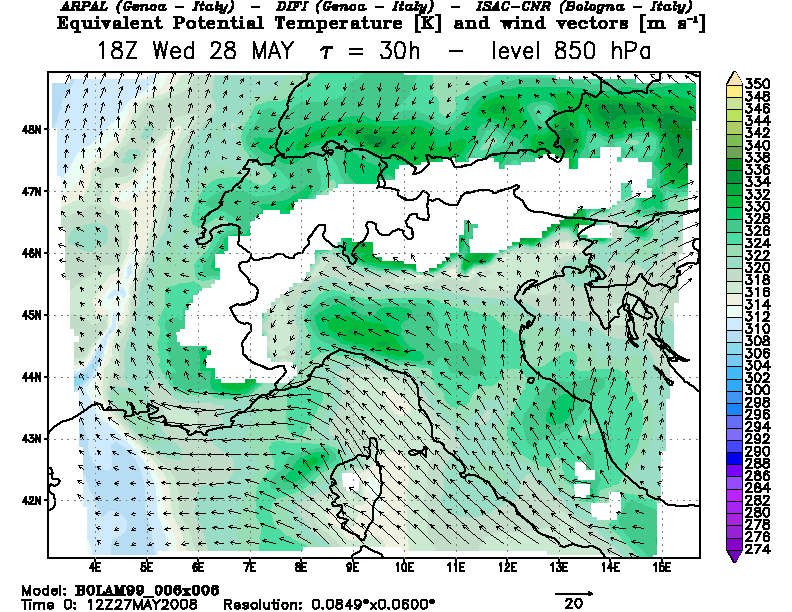
Bolam hat für Morgen als praktisch einziges Modell Niederschläge in der Ostschweiz/Bodensee drin. Die werden durch eine Konvergenz zwischen Föhn und schwachem Nordostwind ausgelöst.
Generell sind die Chancen für Gewitter Morgen vor allem westlich des Napfs erhöht.
Gruss
Bernhard
Generell sind die Chancen für Gewitter Morgen vor allem westlich des Napfs erhöht.
Gruss
Bernhard
Bernhard Oker - Urdorf (ZH/CH) - Meine Webseiten "Never Stop Chasing!"
-
Tinu (Männedorf)

- Beiträge: 4029
- Registriert: Fr 29. Jul 2005, 16:35
- Geschlecht: männlich
- Wohnort: 8708 Männedorf
- Hat sich bedankt: 749 Mal
- Danksagung erhalten: 1851 Mal
Gewitter am 28.05.2008
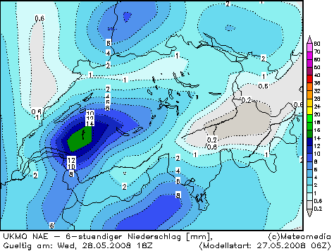
UKMO sieht ebenfalls geringes Potenzial für Niederschläge im Osten:
Allerdings würde ich mich in den kommenden Tagen nicht so auf die Modelle verlassen. Der Alpenraum wird regelrecht von flachen Bodentiefs belagert. Wer dabei wann, wo und wie punkto Gewitter zum Zuge kommen wird, lässt sich kaum exakt vorhersagen. Wenn man bsp. die Modellläufe der letzten paar Tage von GFS und ECMWF etwas verfolgt hat, dann ist einem aufgefallen, dass es von Lauf zu Lauf immer wieder kleine, aber in ihrer Auswirkung sehr bedeutende Veränderungen gegeben hat. Alleine schon die stationäre und immer wieder rückläufig werdende Kaltfront über Frankreich ist aus meiner Sicht eine Wissenschaft für sich.
Allerdings würde ich doch auch dazu tendieren, dass es im Osten bis mindestens Donnerstag trocken bleibt. Der Grund dafür ist der Föhn. Die südliche Anströmung wechselt im Verlauf des Mittwochs von Südwest über Süd nach Südost (UKMO). Für den Osten ist das im Prinzip aber egal, weil eine Föhnströmung dadurch erhalten bleibt.
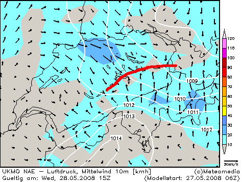
Die von @Bernhard angesprochene Konvergenz am Mittwochabend im Osten ist bei UKMO ebenfalls zu erkennen:
Warten wir es ab.
Allerdings würde ich mich in den kommenden Tagen nicht so auf die Modelle verlassen. Der Alpenraum wird regelrecht von flachen Bodentiefs belagert. Wer dabei wann, wo und wie punkto Gewitter zum Zuge kommen wird, lässt sich kaum exakt vorhersagen. Wenn man bsp. die Modellläufe der letzten paar Tage von GFS und ECMWF etwas verfolgt hat, dann ist einem aufgefallen, dass es von Lauf zu Lauf immer wieder kleine, aber in ihrer Auswirkung sehr bedeutende Veränderungen gegeben hat. Alleine schon die stationäre und immer wieder rückläufig werdende Kaltfront über Frankreich ist aus meiner Sicht eine Wissenschaft für sich.
Allerdings würde ich doch auch dazu tendieren, dass es im Osten bis mindestens Donnerstag trocken bleibt. Der Grund dafür ist der Föhn. Die südliche Anströmung wechselt im Verlauf des Mittwochs von Südwest über Süd nach Südost (UKMO). Für den Osten ist das im Prinzip aber egal, weil eine Föhnströmung dadurch erhalten bleibt.
Die von @Bernhard angesprochene Konvergenz am Mittwochabend im Osten ist bei UKMO ebenfalls zu erkennen:
Warten wir es ab.
Tinu (Männedorf ZH, 422 m ü. M)
Gewitter und Sturm = erhöhter Pulsschlag
Föhn-fasziniert
Gewitter und Sturm = erhöhter Pulsschlag
Föhn-fasziniert
-
Thies (Wiesental)

- Beiträge: 1818
- Registriert: Fr 17. Aug 2001, 07:29
- Wohnort: 79688 Hausen im Wiesental (D)
- Hat sich bedankt: 148 Mal
- Danksagung erhalten: 95 Mal
Gewitter am 28.05.2008
Hm, das könnte auch am Oberrhein interessant werden. Nordwestliche Bodenanströmung bei labiler Schichtung triggert im Normalfall immer mal wieder dicke Zellen am Ostrand der Vogesen. Mal schauen, das ist auf jeden Fall eine schwierige Nowcasting-Angelegenheit...
Gruss, Thies
PS: 0z und 6z scheinen nach dem aktuellen Stand eine "loaded gun" am Donnerstag provozieren zu wollen bei Theta E-Werten von bis zu 70° über dem Schwarzwald. Wow...
Gruss, Thies
PS: 0z und 6z scheinen nach dem aktuellen Stand eine "loaded gun" am Donnerstag provozieren zu wollen bei Theta E-Werten von bis zu 70° über dem Schwarzwald. Wow...
Thies Stillahn (Gewitterjagd im Dreiländereck D/CH/F)
-
Andreas -Winterthur-

- Beiträge: 4383
- Registriert: Do 19. Jul 2012, 07:38
- Hat sich bedankt: 339 Mal
- Danksagung erhalten: 598 Mal
Gewitter am 28.05.2008
Hallo
Ja, Donnerstag sehr spannend. Föhnebise in der Grundschicht oben strammer Südost. Sehr hohe Theta-E die von Osten zurückkommen. So wie es aussieht, wird am Donnerstag die föhngeschwächte Front welche morgen von Frankreich reindriftet am Donnerstag wieder rückläufig. Gleichzeitig streift Höhenkaltluft des abspaltenden Höhentrogs darüber (in der Nacht auf Freitag). Unwetterartige Niederschläge sind übrigens für das Simplon-Gebiet zu erwarten:
http://www.meteoschweiz.admin.ch/web/de ... ahren.html
Gruss Andreas
“Some people are weather wise, but most are otherwise” Benjamin Franklin
-
Marco (Bettlach)
Gewitter am 28.05.2008
@ Bernhard: Ich habe auf skywarn.ch das Sounding von Payerne angekuckt. Ein CAPE von 2'000...stimmt da was nicht?
-
Dwalin (Muttenz)

- Beiträge: 1306
- Registriert: So 5. Dez 2004, 19:44
- Wohnort: 4132 Muttenz
Gewitter am 28.05.2008
@Marco, wenn 2000 dan eher Montags... zie dir mal die Werte bei GFS rein :T 
Gut bis dahin fliesst noch viel Wasser den Rhein hinab
gruss
Gut bis dahin fliesst noch viel Wasser den Rhein hinab
gruss
Allradantrieb bedeutet, daß Dein Auto dort stecken bleibt,
wo der Abschleppwagen nicht hinkommt.
Die Windstärke steigt direkt proportional zu den Kosten Deiner neuen Frisur
wo der Abschleppwagen nicht hinkommt.
Die Windstärke steigt direkt proportional zu den Kosten Deiner neuen Frisur
-
Bernhard Oker
- Moderator
- Beiträge: 6515
- Registriert: Do 16. Aug 2001, 11:02
- Geschlecht: männlich
- Wohnort: 8902 Urdorf
- Hat sich bedankt: 1863 Mal
- Danksagung erhalten: 3108 Mal
Gewitter am 28.05.2008
@Marco
Damit ist schon alles in Ordnung, kommt halt auf das aufsteigende Luftpacket (Parcel) an das gewählt wird.
Die 12Z Sondierung von heute hat leider falsche Windwerte. Hätte sicher sehr hohe SRH Werte gegeben.
Gruss
Bernhard
Damit ist schon alles in Ordnung, kommt halt auf das aufsteigende Luftpacket (Parcel) an das gewählt wird.
Die 12Z Sondierung von heute hat leider falsche Windwerte. Hätte sicher sehr hohe SRH Werte gegeben.
Gruss
Bernhard
Bernhard Oker - Urdorf (ZH/CH) - Meine Webseiten "Never Stop Chasing!"