Seite 1 von 15

Gewitterlage 12.05.2009 - Nowcast

Verfasst: Di 12. Mai 2009, 01:09
von Badnerland
Sali,

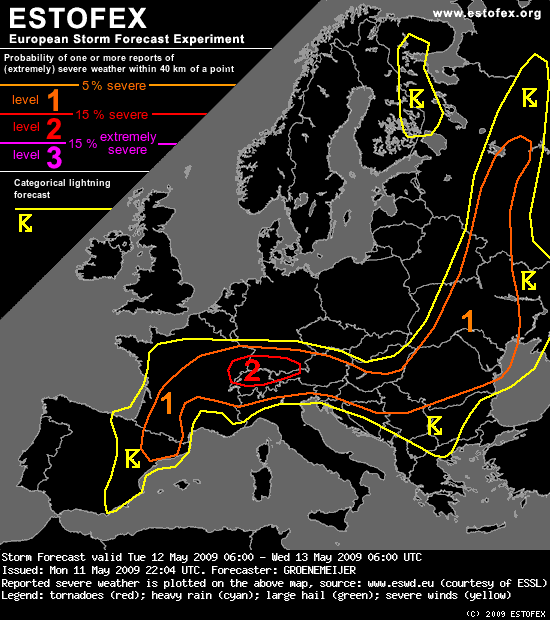
heute könnten wir mitten drin statt nur dabei sein, zumindest wenn man rein vom Estofex Outlook ausgeht...:
Bild
Storm Forecast
Valid: Tue 12 May 2009 06:00 to Wed 13 May 2009 06:00 UTC
Issued: Mon 11 May 2009 22:04
Forecaster: GROENEMEIJER

....
A level 2 was issued for E France, S Germany, N Switzerland, and NW Austria mainly for large hail, and severe winds.
....
SYNOPSIS

Tuesday at 0600 UTC, mid-level charts feature an intense trough from northern Scandinavia to W Poland. During the forecast period, a low cuts off from the trough and becomes established over Smolensk Oblast. There, intense surface cyclogenesis is also expected as the upper-level systems interacts with a frontal zone. Upstream of the trough, a ridge stretches from the Shetlands to W Germany. Further upstream, a low is situated over the Bay of Biscay. On the SE flank of that low, a 30 m/s jet streak is present from SW Iberia to the Alps. While being well-defined in the lower troposphere also, it tends to propagate downstream somewhat during the period. A subtle shortwave ridge over Iberia moves NE ward and connects with the Shetland-W Germany ridge. A baroclinic zone stretches across eastern Spain towards central France. A clear surface front stretches eastward across Europe, from the Paris region eastward across southern Germany to N Hungary, to E Belarus -- where the surface cyclogenesis is expected -- and onwards along the Valdai Hills to the northern Russian Plain.

DISCUSSION

E France, S Germany, Switzerland, Austria, N Italy...

A rather moist air-mass that has become stagnant south of the warm front mentioned above. As this air-mass is warmed during the day, CAPEs well in excess of 1000 J/kg, possibly up to 2000 J/kg are expected to form north of the Alps. This, in combination with strong 20-25 m/s shear, will lead to a situation in which rotating storms can develop with ease. Scattered storms will probably form in the early afternoon in response to diurnal heating. They will bear a threat of large hail. A risk of severe winds will also exist. The risk of tornadoes appears not to be exceptionally large, because of the relatively low 0-1 km shear. However, high amounts of low-level buoyancy and locally enhanced shear may still allow for one or two tornadoes to develop, especially in vicinity of the front.
The storms may continue into the evening, but will gradually subside.

Across the Alps and on the southern flanks of the Alps, storms are also expected to occur. Instability will be less, so the threat of large hail will be a bit lower, but still significant. Some severe wind gusts are possible in addition to the hail threat.
....
http://estofex.org/cgi-bin/polygon/show ... recast.xml

Gute Nacht,
Benni

Re: Gewitterlage 12.05.2009 - Nowcast

Verfasst: Di 12. Mai 2009, 02:07
von 221057Gino
Hallo zusammen ( für die wo noch wach sind )

He ! He ! ... volltreffer ... ;)

http://www.sturmforum.ch/viewtopic.php?p=103733#p103733
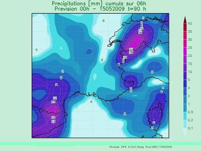
Traumhaft gemäss GFS Modell in etwa 90 Std. ...

Bild

Re: Gewitterlage 12.05.2009 - Nowcast

Verfasst: Di 12. Mai 2009, 02:34
von 221057Gino
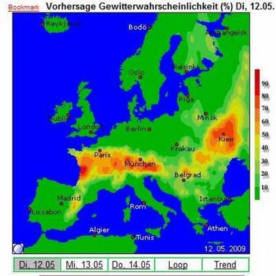
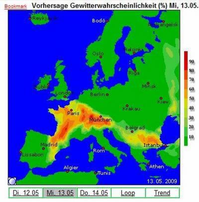
Was für ein herrlichen Frühlingsanfang 2009 ...

Bild

Bild

Re: Gewitterlage 12.05.2009 - Nowcast

Verfasst: Di 12. Mai 2009, 06:19
von Christian Schlieren
Guten Morgen

Hmm heute könnte doch noch ein Richtig Spannender Tag werden :-D
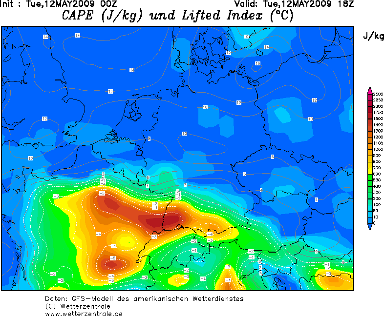
GFS Rechnet nun am Abend auch viel CAPE! und die Zugrichtung der Zellen währe nicht schlecht für die Flachländer ;)
Das Problem könnte aber Mangelnder Sonnenschein sein, den im Moment ziehen einige Schauer aus Westen in die Schweiz, ich Rechne damit das es bis gegen Mittag Bewölkt ist mit einzelnen Schauer, aber wens am Nachmitat auftut und die Sonne Richtig einheizt währen die Schauer gar nicht mal schlecht da sie für ein wenig zusatz Feuchte sorgen dürften.
Wens aber auch am Nachmitag bewölkt bleibt glaube ich nicht an kräftige Gewitter.

Bild


Gruss

Re: Gewitterlage 12.05.2009 - Nowcast

Verfasst: Di 12. Mai 2009, 07:50
von spn
Level 2 für grosse Teile der Schweiz. Das könnte gut abgehen heute. Ich rechne damit das sich zum mindest im Westen schon gegen Mittag das ganze auflockert und es dann ordentlich einheizen kann. Wie Christian schon schrieb könnte das sogar, in Verbindung mit den jetzigen Schauern, für nochmaligen Boost in Form von Feuchte sorgen. Zum Teil lockert es jetzt schon mächtig bei mir in der Wolkendecke auf.
Bild
Auf dem Satbild schön zusehen das es hinter der Front gut auftut.

Auf einen spannenden Tag

Re: Gewitterlage 12.05.2009 - Nowcast

Verfasst: Di 12. Mai 2009, 08:19
von Thies (Wiesental)
Moin,

Vorteil der ganzen Bewölkung und Feuchte wäre ja im Idealfall, dass die ganze Luftmasse erst mal noch etwas gedeckelt bleibt, sobald es auflockert. Und zumindest laut Sat sieht ja aktuell so aus. Das kann seeeehr spannend werden.

Beste Grüsse, Thies

Re: Gewitterlage 12.05.2009 - Nowcast

Verfasst: Di 12. Mai 2009, 09:08
von Joachim
Hallo

neben der Sonne gibt es auch noch das (viel wichtigere) dynamische forcing...Tröglis im 500-er.

Einer davon sorgt jetzt wieder für den Wolken-/Regenschub im Jura-/Nordschweiz: 6 mm m/Std in Schupfart (08-09 Uhr).

Nachmittags und abends mit antizyklonaler Krümmung wieder der Daumen auf der Konvektion...Luftmasse und CAPE ist eben nur ein Teil der Gewittersuppe.
00z EZ simuliert stärkere Gewitter auch nur zwischen Schwarzwald-Allgäu ... abgesehen von der Nordschweiz (Jura-Bodensee) wäre demnach die CH wieder nur am Rande.

In der Höhe hat der Südwestwind deutlich zugenommen...Kl. Matterhorn bis 120 km/h, La Dôle 74 km/h.

Joachim

Re: Gewitterlage 12.05.2009 - Nowcast

Verfasst: Di 12. Mai 2009, 09:26
von Heiziger
hallo zäme

petrus hat im westen die heizung angeworfen.
es darf gekocht werden :mrgreen: :unschuldig:

greez pat

Re: Gewitterlage 12.05.2009 - Nowcast

Verfasst: Di 12. Mai 2009, 10:49
von Thies (Wiesental)
Hm, über Freiburg ist es neblig und nach wie vor bedeckt bei 14°C. Es sollte schon bald mal aufreissen, damit hier noch was passiert (aus der Grundschicht). Ansonsten heisst es wohl wieder an den Jura fahren zu müssen heute Abend. Dabei wären die Bodenwinde für stärkere Entwicklungen im Rheingraben ideal.

Beste Grüsse, Thies

Re: Gewitterlage 12.05.2009 - Nowcast

Verfasst: Di 12. Mai 2009, 10:54
von nordspot
Hi allerseits.
Na südlich von Stuttgart wirds schön elektrisch wieder, und hier in KN kommt auch immer mehr die Sonne raus. Gut so :-D
@ Thies: Bei dir müßte es doch auch bald aufreißen?

Grüße

Ralph